- Carroll County (Illinois)
-
Verwaltung US-Bundesstaat: Illinois Verwaltungssitz: Mount Carroll Adresse des
Verwaltungssitzes:County Board Chairman
635 S. Clay Street
Mt. Carroll, IL 61053Gründung: 1839 Vorwahl: 001 815 Demographie Einwohner: 15.387 (2010) Bevölkerungsdichte: 13,4 Einwohner/km² Geographie Fläche gesamt: 1.206 km² Wasserfläche: 56 km² Karte 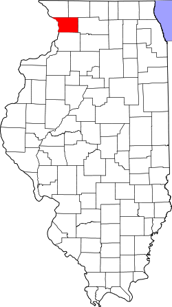
Website: www.gocarrollcounty.com Das Carroll County[2] ist ein County im US-amerikanischen Bundesstaat Illinois. Bei der Volkszählung im Jahr 2010 hatte das County 15.387 Einwohner und eine Bevölkerungsdichte von 13,4 Einwohnern pro Quadratkilometer. Der Verwaltungssitz (County Seat) ist Mount Carroll.[3]
Inhaltsverzeichnis
Geografie
Das County liegt im Nordwesten von Illinois und hat eine Fläche von 1.206 Quadratkilometern, wovon 56 Quadratkilometer Wasserfläche sind. Die westliche Countygrenze ist auch gleichzeitig die Grenze zum Bundesstaat Iowa und ist natürlich durch den Mississippi River bestimmt. An das Carroll County grenzen folgende Nachbarcountys:
Jo Daviess County Stephenson County Jackson County
(Iowa)
Ogle County Clinton County
(Iowa)Whiteside County Geschichte
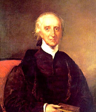
 Charles Carroll
Das Carroll County wurde 1838 aus ehemaligen Teilen des Jo Davies County gebildet. Benannt wurde es nach Charles Carroll (1737-1832), einem Großbrundbesitzer und Politiker aus Maryland und einzigem katholischen Unterzeichner der Unabhängigkeitserklärung der USA.
Die Entscheidung das County nach ihm zu benennen, traf Issac Chambers, der erste Siedler in diesem Gebiet. Die wirkliche Besiedlung begann erst, nachdem die Emmert, Halderman & Co. die erste Sägemühle auf dem Gebiet von Mount Carroll erbauten und damit Arbeitsplätze erschufen. Das geschlagene Holz wurde über den angrenzenden Mississippi abtransportiert. Nachdem die ersten Holzhütten durch die Gesellschaft für die Mitarbeiter gebaut worden waren, wurden 1844 die ersten öffentlichen Gebäude gebaut. Im gleichen Jahr kam auch Joe Miles, der erste Jurist, in diese Gegend und eröffnete eine Handelsstation, sowie die erste Post-Station. 1869 wurde die erste reguläre Schule mit 5 Unterrichtsräumen und 5 Lehrkräften in Betrieb genommen.
Demografische Daten
Historische Einwohnerzahlen Census Einwohner ± in % 1840 1023 — 1850 4586 300 % 1860 11.733 200 % 1870 16.705 40 % 1880 16.976 2 % 1890 18.320 8 % 1900 18.963 4 % 1910 18.035 -5 % 1920 19.345 7 % 1930 18.433 -5 % 1940 17.987 -2 % 1950 18.976 5 % 1960 19.507 3 % 1970 19.276 -1 % 1980 18.779 -3 % 1990 16.805 -10 % 2000 16.674 -0,8 % 2010 15.387 -8 % Vor 1900[4] 1900–1990[5] 2000[6] 2010[7] Nach der Volkszählung im Jahr 2010 lebten im Carroll County 15.387 Menschen in 6.969 Haushalten. Die Bevölkerungsdichte betrug 13,4 Einwohner pro Quadratkilometer.
Ethnisch betrachtet setzte sich die Bevölkerung zusammen aus 96,9 Prozent Weißen, 0,8 Prozent Afroamerikanern, 0,3 Prozent amerikanischen Ureinwohnern, 0,3 Prozent Asiaten sowie aus anderen ethnischen Gruppen; 1,1 Prozent stammten von zwei oder mehr Ethnien ab. Unabhängig von der ethnischen Zugehörigkeit waren 2,8 Prozent der Bevölkerung spanischer oder lateinamerikanischer Abstammung.
In den 6.969 Haushalten lebten statistisch je 2,22 Personen.
20,5 Prozent der Bevölkerung waren unter 18 Jahre alt, 58,3 Prozent waren zwischen 18 und 64 und 21,2 Prozent waren 65 Jahre oder älter. 49,9 Prozent der Bevölkerung war weiblich.
Das jährliche Durchschnittseinkommen eines Haushalts lag bei 41.578 USD. Das Pro - Kopf - Einkommen betrug 24.904 USD. 13,2 Prozent der Einwohner lebten unterhalb der Armutsgrenze.[8]
Städte und Gemeinden
- Lanark
- Mount Carroll
- Savanna
- Chadwick
- Milledgeville
- Shannon
- Thomson
Einzelnachweise
- ↑ Auszug aus dem National Register of Historic Places Abgerufen am 13. März 2011
- ↑ GNIS-ID: 424209. Abgerufen am 22. Februar 2011 (englisch).
- ↑ National Association of Counties Abgerufen am 18. November 2011
- ↑ U.S. Census Bureau - Census of Population and Housing Abgerufen am 15. März 2011
- ↑ Auszug aus Census.gov Abgerufen am 14. Februar 2011
- ↑ U.S. Census Buero - Volkszählungsdaten 2000 für das Carroll County, IL Abgerufen am 18. November 2011
- ↑ United States Census 2010 Abgerufen am 18. November 2011
- ↑ U.S. Census Buero, State & County QuickFacts - Carroll County Abgerufen am 18. November 2011
Weblinks
-
 Commons: Carroll County, Illinois – Sammlung von Bildern, Videos und Audiodateien
 - Offizielle Webseite
- U.S. Census Buero, State & County QuickFacts - Carroll County
- Yahoo Bildersuche - Carroll County
- www.city-data.com - Carroll County
- Illinois State Archives - Carroll County

Liste der Countys in Illinois
Adams | Alexander | Bond | Boone | Brown | Bureau | Calhoun | Carroll | Cass | Champaign | Christian | Clark | Clay | Clinton | Coles | Cook | Crawford | Cumberland | DeKalb | DeWitt | Douglas | DuPage | Edgar | Edwards | Effingham | Fayette | Ford | Franklin | Fulton | Gallatin | Greene | Grundy | Hamilton | Hancock | Hardin | Henderson | Henry | Iroquois | Jackson | Jasper | Jefferson | Jersey | Jo Daviess | Johnson | Kane | Kankakee | Kendall | Knox | LaSalle County | Lake | Lawrence | Lee | Livingston | Logan | Macon | Macoupin | Madison | Marion | Marshall | Mason | Massac | McDonough | McHenry | McLean | Menard | Mercer | Monroe | Montgomery | Morgan | Moultrie | Ogle | Peoria | Perry | Piatt | Pike | Pope | Pulaski | Putnam | Randolph | Richland | Rock Island | Saline | Sangamon | Schuyler | Scott | Shelby | St. Clair | Stark | Stephenson | Tazewell | Union | Vermilion | Wabash | Warren | Washington | Wayne | White | Whiteside | Will | Williamson | Winnebago | Woodford
Wikimedia Foundation.
Schlagen Sie auch in anderen Wörterbüchern nach:
Carroll County, Illinois — Infobox U.S. County county = Carroll County state = Illinois seallink = map size = 150 founded = 1839 seat = Mount Carroll largest city = Savanna area total sq mi = 466 area total km2 = 1206 area land sq mi = 444 area land km2 = 1150 area water… … Wikipedia
Mount Carroll Township, Carroll County, Illinois — Mount Carroll Township Township Location in Carroll County … Wikipedia
Cherry Grove-Shannon Township, Carroll County, Illinois — Cherry Grove Shannon Township Township Location in … Wikipedia
Rock Creek-Lima Township, Carroll County, Illinois — Infobox Settlement unit pref=Imperial settlement type=Township official name = Rock Creek Lima Township nickname = motto = imagesize = image caption = image mapsize = map caption = Location in Carroll County subdivision type = Country subdivision … Wikipedia
Elkhorn Grove Township, Carroll County, Illinois — Infobox Settlement unit pref=Imperial settlement type=Township official name = Elkhorn Grove Township nickname = motto = imagesize = image caption = image mapsize = map caption = Location in Carroll County subdivision type = Country subdivision… … Wikipedia
Fairhaven Township, Carroll County, Illinois — Infobox Settlement unit pref=Imperial settlement type=Township official name = Fairhaven Township nickname = motto = imagesize = image caption = image mapsize = map caption = Location in Carroll County subdivision type = Country subdivision name … Wikipedia
Freedom Township, Carroll County, Illinois — Infobox Settlement unit pref=Imperial settlement type=Township official name = Freedom Township nickname = motto = imagesize = image caption = image mapsize = map caption = Location in Carroll County subdivision type = Country subdivision name =… … Wikipedia
Salem Township, Carroll County, Illinois — Infobox Settlement unit pref=Imperial settlement type=Township official name = Salem Township nickname = motto = imagesize = image caption = image mapsize = map caption = Location in Carroll County subdivision type = Country subdivision name =… … Wikipedia
Savanna Township, Carroll County, Illinois — Infobox Settlement unit pref=Imperial settlement type=Township official name = Savanna Township nickname = motto = imagesize = image caption = image mapsize = map caption = Location in Carroll County subdivision type = Country subdivision name =… … Wikipedia
Washington Township, Carroll County, Illinois — Infobox Settlement unit pref=Imperial settlement type=Township official name = Washington Township nickname = motto = imagesize = image caption = image mapsize = map caption = Location in Carroll County subdivision type = Country subdivision name … Wikipedia
Carroll County (Illinois)


18+
© Academic, 2000-2024
- Kontaktieren Sie uns: Unterstützung, Werbung
Wörterbücher Export, schritte mit PHP, Joomla, Drupal, WordPress, MODx.