Castle Valley

Castle Valley
Castle Valley
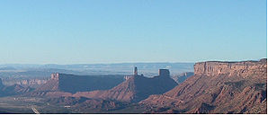
Der Castle Rock in der Nähe von Castle Valley
Lage in Utah
Castle Valley (Utah)
Castle Valley
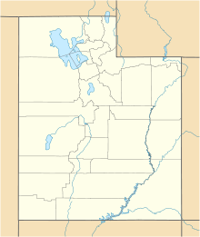
Castle Valley
Basisdaten
Staat: Vereinigte Staaten
Bundesstaat: Utah
County:

Grand County

Koordinaten: 38° 38′ N, 109° 25′ W38.634444444444-109.410555555561428Koordinaten: 38° 38′ N, 109° 25′ W
Zeitzone: Mountain Standard Time (UTC−7)
Einwohner: 349 (Stand: 2000)
Bevölkerungsdichte: 16,7 Einwohner je km²
Fläche: 20,9 km² (ca. 8 mi²)
davon 20,9 km² (ca. 8 mi²) Land
Höhe: 1428 m
Postleitzahl: 84532
Vorwahl: +1 435
FIPS: 49-11000
GNIS-ID: 1450284
Webpräsenz: www.castlevalleyutah.com
Bürgermeister: Damian Bollermann

Castle Valley ist ein Dorf im Grand County im Südosten des US-Bundesstaates Utah. Castle Valley hat 349 Einwohner auf einer Fläche von 20,9 km². Die Bevölkerungsdichte liegt bei 16,7/km². Castle Valley liegt nahe Moab und nahe dem Arches-Nationalpark.


Wikimedia Foundation.

Игры ⚽ Поможем написать реферат

Schlagen Sie auch in anderen Wörterbüchern nach:

  • Castle Valley — Castle Valley, UT U.S. town in Utah Population (2000): 349 Housing Units (2000): 230 Land area (2000): 8.082417 sq. miles (20.933364 sq. km) Water area (2000): 0.000000 sq. miles (0.000000 sq. km) Total area (2000): 8.082417 sq. miles (20.933364… …   StarDict's U.S. Gazetteer Places

  • Castle Valley, UT — U.S. town in Utah Population (2000): 349 Housing Units (2000): 230 Land area (2000): 8.082417 sq. miles (20.933364 sq. km) Water area (2000): 0.000000 sq. miles (0.000000 sq. km) Total area (2000): 8.082417 sq. miles (20.933364 sq. km) FIPS code …   StarDict's U.S. Gazetteer Places

  • Castle Valley — 38° 38′ 04″ N 109° 24′ 38″ W / 38.634444, 109.410556 …   Wikipédia en Français

  • Castle Valley (Utah) — Saltar a navegación, búsqueda Vista de Valley, Utah Castle Valley es una localidad del condado de Grand, estado de Utah, Estados Unidos. Según el censo de 2000, la población era de 349 habitantes …   Wikipedia Español

  • Castle Valley, Utah — Infobox Settlement official name = Castle Valley, Utah settlement type = Town nickname = motto = imagesize = image caption = image mapsize = 250px map caption = Location of Castle Valley, Utah mapsize1 = map caption1 = subdivision type = Country… …   Wikipedia

  • Castle Dale — Museum von San Rafael Lage in Utah …   Deutsch Wikipedia

  • Ruined Castle Valley — noun a valley in central eastern Qld near the upper Dawson River. {named such because of the similarity of its rock formations to the ruined castles of Germany} …  

  • Castle Dale, Utah — Infobox Settlement official name = Castle Dale, Utah settlement type = City nickname = motto = imagesize = image caption = Castle Dale s city hall image mapsize = 250px map caption = Location of Castle Dale, Utah mapsize1 = map caption1 =… …   Wikipedia

  • Castle Frank Brook — Castle Frank redirects here. For the TTC subway station, see Castle Frank (TTC). Coordinates: 43°40′11″N 79°21′31″W / 43.66972°N 79.35861°W …   Wikipedia

  • Castle Pines Village, Colorado — Castle Pines Village   Unincorporated area (U6)   …   Wikipedia

Share the article and excerpts

Direct link
Do a right-click on the link above
and select “Copy Link”