Ingleborough

Ingleborough
54.165922-2.397506
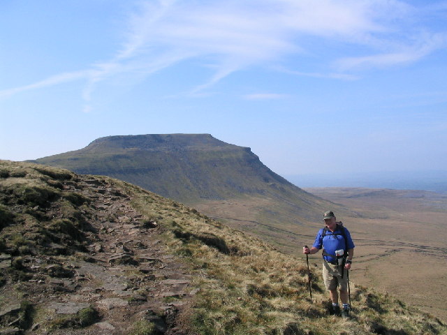
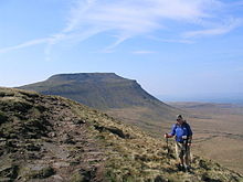
Blick zum Ingleborough vom Simon Fell

Der Ingleborough ist mit 723 m der zweithöchste Berg in den Yorkshire Dales in Nordengland.

Der Berg liegt im Südwesten der Yorkshire Dales und ist der höchste Punkt in einem Dreieck, das von den Orten Ingleton, Ribblehead und Settle gebildet wird.

Der Name des Berges leitet sich aus dem Altenglischen her. Der Ausdruck "burh" bedeutet 'befestigter Platz' und tatsächlich lassen sich an der Nord- und Ostseite des Gipfels noch die Überreste einer Befestigungsanlage erkennen, die dem keltischen Stamm der Brigantes, dem größten Stamm der Eisenzeit in Britannien zugeschrieben wird.

Der Gipfel ist ein Plateau mit einem Umfang von etwa 800 m, bedeckt mit einer dünnen Grasnarbe. Auf dem Gipfel befindet sich ein Windschutz mit einer Erklärung der Aussicht. An klaren Tagen reicht der Blick bis zum 166 km entfernten Berg Manod Mawr in Snowdonia in Nord-Wales. Gut sichtbar sind auch die Berge des Lake District Nationalparks wie etwa der Helvellyn. Der Blick reicht auch hinüber bis zur Stadt Lancaster und auf die angrenzende Morecambe Bay. Auf dem Gipfel befinden sich eine Markierung und ein trigonometrischer Punkt der Ordnance Survey (Nr. S. 5619).

Ingleborough kann als Teil des Three-Peaks-Walks von verschiedenen Seiten bestiegen werden.

Weblinks

 Commons: Ingleborough – Sammlung von Bildern, Videos und Audiodateien

Wikimedia Foundation.

Игры ⚽ Поможем написать реферат

Schlagen Sie auch in anderen Wörterbüchern nach:

  • Ingleborough — (spr. Ingelborro), Spitze der zu dem Peakgebirge gehörigen Yorkshire Hills, im West Riding der englischen Grafschaft York; 3752 Fuß hoch …   Pierer's Universal-Lexikon

  • Ingleborough — Infobox Mountain Name = Ingleborough Photo = Ingleborough whole.jpg Caption = The whole of Ingleborough as seen from the peat bog below Elevation = 723 m (2373 ft) Location = Yorkshire Dales, England Range = Prominence = c. 427 m Parent peak =… …   Wikipedia

  • Ingleborough Cave — discovery = 1837 geology = Limestone number of entrances = 5 access = £6 when open Ingleborough Cave is a show cave close to the village of Clapham, North Yorkshire, England adjacent to where the water from Gaping Gill resurges.It has many… …   Wikipedia

  • Clapham, North Yorkshire — Coordinates: 54°07′12″N 2°23′22″W / 54.12010°N 2.38942°W / 54.12010; 2.38942 …   Wikipedia

  • Gaping Gill — Infobox Cave name = Gaping Gill photo = Gaping Gill.jpg caption = entrance shaft viewed from the Main Chamber location = Ingleborough depth = convert|105|m|ft|0|lk=on [http://www.bpc cave.org.uk/gaping gill.htm Gaping Gill ] ] length = convert|11 …   Wikipedia

  • Yorkshire three peaks — The mountains of Whernside (convert|736|m|ft|0|abbr=on|disp=/) Ingleborough (convert|723|m|ft|0|abbr=on|disp=/) and Pen y ghent (convert|694|m|ft|0|abbr=on|disp=/) are collectively known as the(Yorkshire) Three Peaks. The peaks, which form part… …   Wikipedia

  • Ingleton, North Yorkshire — infobox UK place country = England latitude= 54.1512 longitude= 2.4723 official name= Ingleton population = 2050 shire district= Craven region= Yorkshire and the Humber shire county = North Yorkshire constituency westminster= Skipton and Ripon… …   Wikipedia

  • Инглборо — Ingleborough …   Википедия

  • Yorkshire Dales — Protected Area National park entrance sign, near Skipton …   Wikipedia

  • Ward's Stone — Infobox Mountain Name = Ward s Stone Photo = Ward s Stone.jpg Caption = The summit rocks of Ward s Stone, with Ingleborough behind on the right Elevation = 561 m (1839 ft) Location = Forest of Bowland, England Range = Prominence = 395 m Parent… …   Wikipedia

Share the article and excerpts

Direct link
Do a right-click on the link above
and select “Copy Link”