- Iporá (Goiás)
-
Iporá (Goiás) Wappen Flagge 
Karte 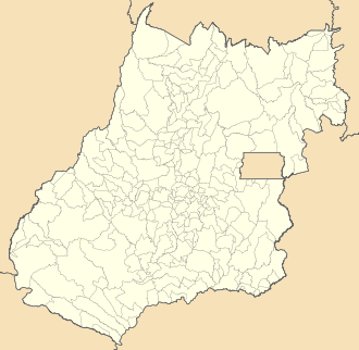

Iporá (Goiás) Lage in Brasilien Lage von Iporá (Goiás)
Basisdaten Staat:  Brasilien (BRA)
Verwaltungsgliederung: Mittelwesten Bundesstaat:  Goiás (GO)
Mesoregion: Zentral-Goiás Mikroregion: Iporá (GO) Geografische Lage: 16° 27′ S, 51° 7′ W-16.441944444444-51.117777777778584Koordinaten: 16° 27′ S, 51° 7′ W Distanz zu Goiânia: 225 km [1] Zeitzone: UTC-3
Sommer: UTC-2Höhe: 584 m ü. NN Fläche: 1.026,387 km² Einwohner: 31.274 [2] Bevölkerungsdichte: 30,5 Einwohner / km² Telefonvorwahl: +5562 Postleitzahl (CEP): 76200-000 Adresse der Gemeindeverwaltung: Offizielle Website: Jahrestag: 14. November Gründungsjahr: 1943 Politik Bürgermeister: José Antonio (PMDB) (2009 – 2012) Vize-Bürgermeister: Iporá ist eine brasilianische politische Gemeinde im Bundesstaat Goiás in der Mesoregion Zentral-Goiás und in der gleichnamigen Mikroregion Iporá. Sie liegt westlich der brasilianischen Hauptstadt Brasília und der Hauptstadt Goiânia.
Geographische Lage
Iporá grenzt
- im Norden an die Gemeinden Diorama und Jaupaci
- im Osten an Israelândia und Moiporá
- im Südosten an Ivolândia
- im Süden an Amorinópolis
- im Südwesten an Ivolândia
- im Westen an Arenópolis
Siehe auch
Einzelnachweise
- ↑ SEPLAN: Straßenkilometer nach Goiânia
- ↑ Erste Ergebnisse der Volkszählung von 2010 in Goiás, durchgeführt vom IBGE.
Gemeinden im Bundesstaat GoiásAbadia de Goiás | Abadiânia | Acreúna | Adelândia | Água Fria de Goiás | Água Limpa | Águas Lindas de Goiás | Alexânia | Aloândia | Alto Horizonte | Alto Paraíso de Goiás | Alvorada do Norte | Amaralina | Americano do Brasil | Amorinópolis | Anápolis | Anhanguera | Anicuns | Aparecida de Goiânia | Aparecida do Rio Doce | Aporé | Araçu | Aragarças | Aragoiânia | Araguapaz | Arenópolis | Aruanã | Aurilândia | Avelinópolis | Baliza | Barro Alto | Bela Vista de Goiás | Bom Jardim de Goiás | Bom Jesus de Goiás | Bonfinópolis | Bonópolis | Brazabrantes | Britânia | Buriti Alegre | Buriti de Goiás | Buritinópolis | Cabeceiras | Cachoeira Alta | Cachoeira de Goiás | Cachoeira Dourada | Caçu | Caiapônia | Caldas Novas | Caldazinha | Campestre de Goiás | Campinaçu | Campinorte | Campo Alegre de Goiás | Campo Limpo de Goiás | Campos Belos | Campos Verdes | Carmo do Rio Verde | Castelândia | Catalão | Caturaí | Cavalcante | Ceres | Cezarina | Chapadão do Céu | Cidade Ocidental | Cocalzinho de Goiás | Colinas do Sul | Córrego do Ouro | Corumbá de Goiás | Corumbaíba | Cristalina | Cristianópolis | Crixás | Cromínia | Cumari | Damianópolis | Damolândia | Davinópolis | Diorama | Divinópolis de Goiás | Doverlândia | Edealina | Edéia | Estrela do Norte | Faina | Fazenda Nova | Firminópolis | Flores de Goiás | Formosa | Gameleira de Goiás | Goianápolis | Goiandira | Goianésia | Goiânia | Goianira | Goiás Velho | Goiatuba | Gouvelândia | Guapó | Guaraíta | Guarani de Goiás | Guarinos | Heitoraí | Hidrolândia | Hidrolina | Iaciara | Inaciolândia | Indiara | Inhumas | Ipameri | Ipiranga de Goiás | Iporá | Israelândia | Itaberaí | Itaguari | Itaguaru | Itajá | Itapaci | Itapirapuã | Itapuranga | Itarumã | Itauçu | Itumbiara | Ivolândia | Jandaia | Jaraguá | Jataí | Jaupaci | Jesúpolis | Joviânia | Jussara | Lagoa Santa | Leopoldo de Bulhões | Luziânia | Mairipotaba | Mambaí | Mara Rosa | Marzagão | Matrinchã | Maurilândia | Mimoso de Goiás | Minaçu | Mineiros | Moiporá | Monte Alegre de Goiás | Montes Claros de Goiás | Montividiu | Montividiu do Norte | Morrinhos | Morro Agudo de Goiás | Mossâmedes | Mozarlândia | Mundo Novo | Mutunópolis | Nazário | Nerópolis | Niquelândia | Nova América | Nova Aurora | Nova Crixás | Nova Glória | Nova Iguaçu de Goiás | Nova Roma | Nova Veneza | Novo Brasil | Novo Gama | Novo Planalto | Orizona | Ouro Verde de Goiás | Ouvidor | Padre Bernardo | Palestina de Goiás | Palmeiras de Goiás | Palmelo | Palminópolis | Panamá | Paranaiguara | Paraúna | Perolândia | Petrolina de Goiás | Pilar de Goiás | Piracanjuba | Piranhas | Pirenópolis | Pires do Rio | Planaltina | Pontalina | Porangatu | Porteirão | Portelândia | Posse | Professor Jamil | Quirinópolis | Rialma | Rianápolis | Rio Quente | Rio Verde | Rubiataba | Sanclerlândia | Santa Bárbara de Goiás | Santa Cruz de Goiás | Santa Fé de Goiás | Santa Helena de Goiás | Santa Isabel | Santa Rita do Araguaia | Santa Rita do Novo Destino | Santa Rosa de Goiás | Santa Tereza de Goiás | Santa Terezinha de Goiás | Santo Antônio da Barra | Santo Antônio de Goiás | Santo Antônio do Descoberto | São Domingos | São Francisco de Goiás | São João d’Aliança | São João da Paraúna | São Luís de Montes Belos | São Luíz do Norte | São Miguel do Araguaia | São Miguel do Passa Quatro | São Patrício | São Simão | Senador Canedo | Serranópolis | Silvânia | Simolândia | Sítio d'Abadia | Taquaral de Goiás | Teresina de Goiás | Terezópolis de Goiás | Três Ranchos | Trindade | Trombas | Turvânia | Turvelândia | Uirapuru | Uruaçu | Uruana | Urutaí | Valparaíso de Goiás | Varjão | Vianópolis | Vicentinópolis | Vila Boa | Vila Propício
Wikimedia Foundation.
Schlagen Sie auch in anderen Wörterbüchern nach:
Mikroregion Iporá (Goiás) — Karte Lokation der Mikroregion Iporá im Bundesstaat … Deutsch Wikipedia
Iporá — Bandera … Wikipedia Español
Iporá — is a small city and municipality in west central Goiás state, Brazil. The population was 31,060 (2007) in a total area of 1,026.4 km² (10/10/2002). It is known as the City of the Clear Waters because of its many streams and rivers. LocationIporá… … Wikipedia
Goias — Goiás Goiás Drapeau … Wikipédia en Français
Iporá Microregion — The Iporá Microregion is a geographical region in central western Goiás state, Brazil. The most important city is Iporá. For a map see [http://www.citybrazil.com.br/go/regioes/ipora/ Citybrazil] Important Data (2007)*Population: 58,845 (64,030 in … Wikipedia
Goiás — For other uses, see Goiás (disambiguation). State of Goiás State … Wikipedia
Goiás — 15° 56′ 00″ S 50° 08′ 00″ W / 15.9333, 50.1333 … Wikipédia en Français
Microregion d'Ipora — Microrégion d Iporá La microrégion d Iporá est l une des cinq microrégions qui subdivisent le centre de l État de Goiás au Brésil. Elle comporte 10 municipalités qui regroupaient 62 202 habitants en 2006 pour une superficie totale de… … Wikipédia en Français
Mesoregionen und Mikroregionen in Goiás — Das brasilianische Institut für Geographie und Statistik (IBGE) unterteilt den Bundesstaat Goiás zu rein statistischen Zwecken in fünf Mesoregionen und in 18 Mikroregionen. Diese Regionen erfüllen keine administrativen politischen Funktionen,… … Deutsch Wikipedia
Microrégion d'Iporá — La microrégion d Iporá est l une des cinq microrégions qui subdivisent le centre de l État de Goiás au Brésil. Elle comporte 10 municipalités qui regroupaient 62 202 habitants en 2006 pour une superficie totale de 7 072 km².… … Wikipédia en Français
Iporá (Goiás)


18+
© Academic, 2000-2024
- Kontaktieren Sie uns: Unterstützung, Werbung
Wörterbücher Export, schritte mit PHP, Joomla, Drupal, WordPress, MODx.