- Longos (Portugal)
-
Santa Cristina de Longos Wappen Karte 
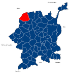
Basisdaten Region: Norte Unterregion: Ave Distrikt: Braga Concelho: Guimarães Koordinaten: 41° 31′ N, 8° 21′ W41.519159-8.35827Koordinaten: 41° 31′ N, 8° 21′ W Einwohner: 1.699 (Stand: 2001) Fläche: 7,2 km² Bevölkerungsdichte: 236 Einwohner pro km² Longos oder Santa Cristina de Longos ist eine Gemeinde im Norden Portugals.
Longos gehört zum Kreis Guimarães im Distrikt Braga, besitzt eine Fläche von 7,2 km² und hat 1699 Einwohner (Stand: 2001).[1] Die Gemeinde ist nur gering urbanisiert.
Einzelnachweise
- ↑ Daten zu Longos. alea.pt, abgerufen am 27. Mai 2011 (englisch).
Weblinks
- Karte der Freguesia Longos beim Instituto Geográfico do Exército
- Information zu Longos. cm-guimaraes.pt, abgerufen am 27. Mai 2011 (PDF, portugiesisch).
 Freguesias im Concelho Guimarães
Abação (São Tomé) | Airão (Santa Maria) | Airão (São João Baptista) | Aldão | Arosa | Atães | Azurém | Balazar | Barco | Briteiros (Salvador) | Briteiros (Santa Leocádia) | Briteiros (Santo Estêvão) | Brito | Caldelas | Calvos | Candoso (Santiago) | Candoso (São Martinho) | Castelões | Conde | Corvite | Costa | Creixomil | Donim | Fermentões | Figueiredo | Gandarela | Gémeos | Gominhães | Gonça | Gondar | Gondomar | Guardizela | Guimarães (Oliveira do Castelo) | Guimarães (São Paio) | Guimarães (São Sebastião) | Infantas | Leitões | Longos | Lordelo | Mascotelos | Mesão Frio | Moreira de Cónegos | Nespereira | Oleiros | Pencelo | Pinheiro | Polvoreira | Ponte | Prazins (Santa Eufémia) | Prazins (Santo Tirso) | Rendufe | Ronfe | Sande (São Clemente) | Sande (São Lourenço) | Sande (São Martinho) | Sande (Vila Nova) | São Faustino | São Torcato | Selho (São Cristóvão) | Selho (São Jorge) | Selho (São Lourenço) | Serzedelo | Serzedo | Silvares | Souto (Santa Maria) | Souto (São Salvador) | Tabuadelo | Urgezes | Vermil
Wikimedia Foundation.
Schlagen Sie auch in anderen Wörterbüchern nach:
Longos — may refer to:Places* In Greece: ** Longos, Achaea, a village in Achaea ** Longos, Phthiotis, a village in the prefecture of Phthiotis ** Longos, Paxoi, a village in the island of Paxoi ** Longos, Phocis, a village in the prefecture of Phocis **… … Wikipedia
Longos Vales — Wappen Karte … Deutsch Wikipedia
Longos Vales — Freguesia de Portugal … Wikipedia Español
Longos — Para la localidad griega, véase Longós. Santa Cristina de Longos Freguesia de Portugal … Wikipedia Español
Longos Vales — Eglise de Longos Vales Longos Vales est l une des paroisses (freguesias) de Monçao, au Portugal. Elle est entourée au nord par Troviscoso, au sud par Merufe, au nord est par Bela et à l ouest par Sago et Cambeses. De plus, elle se trouve à 6 km… … Wikipédia en Français
Monuments of Portugal — The Monuments of Portugal were constructed throughout the Portuguese territory, and date back to the period of pre historic settlement of occupation. Subsequently, the region that is today Portugal has been colonized by many civilizations, which… … Wikipedia
Freguesias de Portugal — Anexo:Freguesias de Portugal Saltar a navegación, búsqueda Contenido 1 A 1.1 Abrantes 1.2 Águeda 1.3 … Wikipedia Español
Anexo:Freguesias de Portugal — Contenido 1 A 1.1 Abrantes 1.2 Águeda 1.3 Aguiar da Beira 1.4 … Wikipedia Español
List of postal codes in Portugal — Aveiro districtMealhada municipality*3050 Antes *3050 Barcouço *3050 Casal Comba *3050 Luso *3050 Mealhada *3050 Pampilhosa *3050 Vacariça *3050 Ventosa do BairroMurtosa municipality*3870 Bunheiro *3870 Monte *3870 Murtosa *3870 TorreiraOliveira… … Wikipedia
Moncao (Portugal) — Monção (Portugal) Pour les articles homonymes, voir Monção. Monção … Wikipédia en Français
Longos (Portugal)


18+
© Academic, 2000-2024
- Kontaktieren Sie uns: Unterstützung, Werbung
Wörterbücher Export, schritte mit PHP, Joomla, Drupal, WordPress, MODx.