Maramasike

Maramasike

Vorlage:Infobox Insel/Wartung/Bild fehlt

Maramasike
Gewässer Pazifischer Ozean
Inselgruppe Salomon-Inseln
Geographische Lage 9° 33′ S, 161° 28′ O-9.5458333333333161.46666666667518Koordinaten: 9° 33′ S, 161° 28′ O
Lage von Maramasike
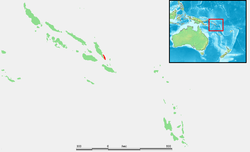
Länge 54 km
Breite 18 km
Fläche 480,5 km²
Höchste Erhebung 518 m
Karte von Maramasike

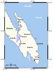
Maramasike, auch South Malaita oder Small Malaita, ist eine Insel in der Malaita-Provinz des Inselstaats der Salomonen. Die etwa 480 km²[1] große Insel liegt unmittelbar südöstlich der Insel Malaita und von dieser getrennt durch die 14,6 km lange und meist nur wenige hundert Meter breite Maramasike Passage, deren Umgebung ein geschütztes Feuchtgebiet ist[2]. Auf der Insel wird Sa'a gesprochen.

Einzelnachweise

  1. UNEP Islands
  2. [1]

Wikimedia Foundation.

Игры ⚽ Поможем написать реферат

Schlagen Sie auch in anderen Wörterbüchern nach:

  • Maramasike Passage — The Maramasike Passage (9°33′S 161°24′E …   Wikipedia

  • South Malaita Island — Maramasike and neighbouring areas South Malaita Island, also known as Small Malaita and Maramasike, is a large island at the southern tip of the larger island of Malaita in the eastern part of the Solomon Islands. It is called small to… …   Wikipedia

  • Malaita — Island seen from space (false color) Geography Locati …   Wikipedia

  • Malaita Province — Coordinates: 9°00′S 161°00′E / 9°S 161°E / 9; 161 …   Wikipedia

  • Malaita (Provinz) — Malaita Geographie Staat: Salomonen Gewässer: Pazifischer Ozean Inseln …   Deutsch Wikipedia

  • Malaita Sur — Este artículo o sección necesita referencias que aparezcan en una publicación acreditada, como revistas especializadas, monografías, prensa diaria o páginas de Internet fidedignas. Puedes añadirlas así o avisar …   Wikipedia Español

  • Malaita — Volcanic island, Solomon Islands, South Pacific Ocean. Located northeast of Guadalcanal, it is about 115 mi (185 km) long and 22 mi (35 km) across at its widest point and has an area of 1,870 sq mi (4,843 sq km). It is mountainous and covered… …   Universalium

  • Malaita (isla) — Isla Malaita Malaita Island Mapa de satélite de Malaita Localización País …   Wikipedia Español

  • Geography of the Solomon Islands — The Solomon Islands are a wide island nation in the South Pacific Ocean, that lies east of Papua New Guinea and consists of many islands: Choiseul, the Shortland Islands, the New Georgia Islands, Santa Isabel, the Russell Islands, the Florida… …   Wikipedia

  • Solomon Islands — For the group of islands rather than the state, see Solomon Islands (archipelago). Solomons redirects here. For the town in the eastern United States, see Solomons, Maryland. Solomon Islands …   Wikipedia

Share the article and excerpts

Direct link
Do a right-click on the link above
and select “Copy Link”