- Metoma
-
Metoma Karte der Torres-Inseln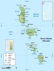
Metoma in der oberen BildhälfteGewässer Korallenmeer Inselgruppe Torres-Inseln Geographische Lage 13° 12′ 29″ S, 166° 36′ 13″ O-13.208055555556166.60361111111Koordinaten: 13° 12′ 29″ S, 166° 36′ 13″ O 

Fläche 3,0 km² Einwohner 13 (2009)
4,3 Einw./km²Metoma (auch Ovale Island) ist eine 3,0 km² große Insel des pazifischen Inselstaats Vanuatu.
Sie liegt zwischen den größeren Inseln Hiu (Hiw) und Tegua, die ebenfalls zu den Torres-Inseln gehören, welche geopolitisch zur vanuatuischen Provinz Torba zählen.
Metoma hatte im Jahr 2009 13 Einwohner.
Schlagen Sie auch in anderen Wörterbüchern nach:
Metoma — Carte des îles Torres Géographie Pays … Wikipédia en Français
Torres-Inseln (Vanuatu) — Torres Inseln Topographische Karte der Torres Inseln Gewässer Korallenmeer … Deutsch Wikipedia
Islas Torres — No debe confundirse con Islas de Torres (Uruguay) o Islas del Estrecho de Torres (Australia). Islas Torres (Torres Islands) Localización geográfica / administrativa Océano (mar) Océano Pacíf … Wikipedia Español
Hiu (Insel) — Hiu (Hiw) Karte der Insel Hiu Gewässer Korallenmeer Inselgruppe … Deutsch Wikipedia
Tegua — Tugue Carte des îles Torres. Tegua est la plus au centre. Géographie Pays … Wikipédia en Français
Îles Torres — Ne pas confondre avec les îles du Détroit de Torrès en Australie. Pour les articles homonymes, voir Torres. îles Torres Torres Islands … Wikipédia en Français
Torres Islands — For the island group between Australia and New Guinea, see Torres Strait Islands. Coordinates: 13°15′S 166°37′E / 13.25°S 166.617°E / … Wikipedia
Islands of Vanuatu — This is a list of the islands by province, largely from north to south, subdivided by archipelago when appropriate. Vanuatu is usually said to contain 83 islands. *Torba Province **Torres Islands ***Hiw ***Metoma ***Tegua ***Nmwel (uninhabited)… … Wikipedia
Ancuabe District — is a district of Cabo Delgado Province in northern Mozambique. It covers 4,606 km² with 109,792 inhabitants. Its seat is the town of Ancuabe.Towns and villagesAdamo · Alenane· Alimo· Aliti· Alumar· Assane· … Wikipedia
Arufo — Arufo … Wikipedia
Metoma


18+
© Academic, 2000-2024
- Kontaktieren Sie uns: Unterstützung, Werbung
Wörterbücher Export, schritte mit PHP, Joomla, Drupal, WordPress, MODx.