- Middle Andaman Island
-
Middle Andaman Island Gewässer Indischer Ozean Inselgruppe Andamanen Geographische Lage 13° 30′ N, 92° 50′ O13.592.833333333333512Koordinaten: 13° 30′ N, 92° 50′ O 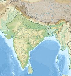

Länge 68 km Breite 31 km Fläche 1.535,50 km² Höchste Erhebung Mount Diavolo
512 mEinwohner 54.385 (2001)
35 Einw./km²Hauptort Rangat Lage von Middle Andaman Island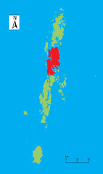
Middle Andaman Island ist die größte der drei Hauptinseln der Andamanen im Indischen Ozean. Politisch gehört die Insel zum indischen Unionsterritorium Andamanen und Nikobaren.
Geographie
Middle Andaman Island liegt im Zentrum des Archipels zwischen North Andaman Island und Baratang, von denen sie nur jeweils durch eine nur wenige Hundert Meter breite Meerenge getrennt ist. Middle Andaman Island ist 68 km lang, bis zu 31 km breit und weist eine Fläche von knapp 1536 km²[1] auf, was sie zur größten Insel sowohl der Andamanen als auch ganz Indiens macht. Die Insel erreicht nahe der Ostküste im Mount Diavolo eine Höhe von 512 Metern.[2] Größte Stadt der Insel ist Rangat. Weitere bedeutende Orte sind Mayabunder, Billiground, Kadamtala, Bakultata und Betapur. Zum Stand der Volkszählung 2001 hatte die Insel insgesamt 54.385 Einwohner.[3]
Bevölkerung
An der Westküste Middle Andamans leben noch wenige hundert Jarawa, eine indigenen Ethnie der Andamanen, die eine ebenfalls Jarawa genannte Sprache aus der Gruppe der andamanischen Sprachen sprechen. Vom ebenfalls indigenen Volk der Großen Andamanesen, beispielsweise der Bo, lebt heutzutage niemand mehr auf Middle Andaman. Die überwiegende Mehrheit der Bevölkerung bilden daher hauptsächlich vom indischen Festland her eingewanderte Ethnien und deren Nachfahren.
Einzelnachweise
- ↑ Island-wise Statistical Outline - 2008. MIDDLE ANDAMAN ISLAND (PDF; englisch)
- ↑ National Geospatial-Intelligence Agency: PUB. 173, Sailing Directions (Enroute): India and the Bay of Bengal, Bethesda, Maryland, Ninth Edition, S. 247
- ↑ Directorate of Economics and Statistics, Andaman and Nicobar Administration, Port Blair: Statistical Hand Book on Andaman District & Nicobar District 2005-2006 Table - 1.8 Tahsil-wise/Island-wise Population of Inhabited Islands (2001 Census) (PDF; englisch) (Summe aus 23894 des Tahsils Mayabunder und 30491 aus dem Tahsil Rangat).
Kategorien:- Insel (Indien)
- Insel (Indischer Ozean)
- Insel (Asien)
- Insel der Andamanen
- Geographie (Andamanen und Nikobaren)

Wikimedia Foundation.