- Nkangala
-
Nkangala
Nkangala District Municipality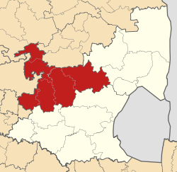
Symbole Wappen
Basisdaten Staat Südafrika Provinz Mpumalanga Sitz Middelburg Fläche 16.892,6 km² Einwohner 1.226.498 (24. Oktober 2007) Dichte 72,6 Einwohner pro km² Schlüssel DC31 ISO 3166-2 ZA-MP Webauftritt www.nkangaladm.org.za (englisch) Politik Bürgermeister Katisi Speedy Mashilo Nkangala ist ein Distrikt innerhalb der Provinz Mpumalanga in Südafrika. Er hat 1.226.498 Einwohner (Stand: 24. Oktober 2007).[1] auf einer Gesamtfläche von 16.893 Quadratkilometern. Sitz der Distriktverwaltung ist Middelburg. Der Distrikt ist benannt nach dem Zulubegriff für Highveld. Die meisten Städte des Distriktes liegen im Highveld.[2]
Gemeinden und Infrastruktur
Die Infrastruktur ist zwischen den städtischen und mehr ländlichen Gemeinden sehr unterschiedlich, als Beispiel hier die Wasserversorgung der Haushalte (HWA = eigener Hauswasseranschluss; ÖWA = öffentlicher Wasseranschluss in der Nähe; KWA = kein Anschluss an ein Wasserleitungsnetz)[3]:
Gemeinde Verwaltungssitz Fläche Einwohner H W A Ö W A K W A Victor Khanye Delmas 1.568 km² 56.205 36 % 49 % 15 % Dr JS Moroka Siyabuswa 1.416 km² 243.308 26 % 43 % 31 % Emalahleni eMalahleni 2.678 km² 276.414 37 % 54 % 9 % Steve Tshwete Middelburg 3.976 km² 142.761 39 % 52 % 9 % Emakhazeni Belfast 4.736 km² 43.008 38 % 41 % 21 % Thembisile Empumalanga 2.384 km² 258.878 36 % 57& 7 % Weblinks und Quellen
- Offizieller Internetauftritt (englisch)
Einzelnachweise
- ↑ Community Survey 2007. Basic Results. Statistics South Africa, 24. Oktober 2007, abgerufen am 29. Juni 2010 (englisch)..
Hinweise zu den Daten (englisch). - ↑ Namensbedeutung Gemeinden
- ↑ Municipal Demarcation Board
Schlagen Sie auch in anderen Wörterbüchern nach:
Nkangala (Distrikt) — Nkangala Nkangala District Municipality Nkangala (blau) in Mpumalanga (dunkelgrau) Staat: Südafrika … Deutsch Wikipedia
Nkangala District Municipality — A map of Mpumalanga showing the Nkangala district Nkangala is one of the 3 districts of Mpumalanga province of South Africa. The seat of Nkangala is Middelburg. The Nkangala District Municipality consists of 160 towns and villages. The most… … Wikipedia
Nkangala language — Not to be confused with Ngangela language. Nkangala Spoken in Angola Native speakers 22,300 (2000) Language family Niger–Congo Atlantic–Congo … Wikipedia
Nkangala District Municipality — Admin ASC 2 Code Orig. name Nkangala District Municipality Country and Admin Code ZA.07.DC31 ZA … World countries Adminstrative division ASC I-II
Nkangala — ISO 639 3 Code : nkn ISO 639 2/B Code : ISO 639 2/T Code : ISO 639 1 Code : Scope : Individual Language Type : Living … Names of Languages ISO 639-3
Liste der Gemeinden in der Provinz Mpumalanga — Mpumalanga mit eingezeichneten Distrikten und Gemeinden Die Liste der Gemeinden in der Provinz Mpumalanga führt alle Gemeinden (Local Municipalities) in der südafrikanischen Provinz Mpumalanga auf. Mpumalanga ist in 3 Distrikte (District… … Deutsch Wikipedia
Delmas Local Municipality — Local municipality Location in M … Wikipedia
Dr JS Moroka Local Municipality — Local municipality Location in … Wikipedia
Liste der Gemeinden Südafrikas — Dies ist eine Liste der südafrikanischen Gemeinden. Inhaltsverzeichnis 1 Metropolgemeinden 2 Freistaat 2.1 Xhariep – Xhariep District Municipality (DC16) 2.2 … Deutsch Wikipedia
Siyabushwa — Siyabuswa DEC … Deutsch Wikipedia
Nkangala


18+
© Academic, 2000-2024
- Kontaktieren Sie uns: Unterstützung, Werbung
Wörterbücher Export, schritte mit PHP, Joomla, Drupal, WordPress, MODx.