- Cherry Creek Lake
-
Cherry Creek Lake Luftbild des Cherry Creek Lake mit Staudamm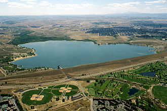
Geographische Lage Arapahoe County, Colorado, USA Zuflüsse Cherry Creek und kleinere Bäche Abfluss Cherry Creek → South Platte River Städte am Ufer Aurora (Colorado) Größere Städte in der Nähe Denver Daten Koordinaten 39° 39′ 5″ N, 104° 51′ 19″ W39.651388888889-104.85527777778Koordinaten: 39° 39′ 5″ N, 104° 51′ 19″ W 

Fläche 3,43 km² Der Cherry Creek Lake [t͡ʃɛɹi ˈkɹiːk ˌleɪk] ist ein Stausee im nördlichen Teil des US-Bundesstaates Colorado – knapp außerhalb der Metropolregion Denver, rund 15 km südöstlich der Staatshauptstadt im Arapahoe County, und staut den Cherry Creek, einen Zufluss des South Platte River.
Der 3,43 km² große und bis zu acht Meter tiefe See entstand durch einen 1950 vom U.S. Army Corps of Engineers (Ingenieurkorp der US-Armee) fertiggestellten - 31 Meter hohen - Staudamm, der neben den später errichteten Dämmen Chatfield und Bear Creek den Großraum Denver vor den Überflutungen des South Platte River schützen sollte. Das Areal um den See ist heute beliebtes Ausflugsziel, das vom Staat Colorado unter den Schutz eines State Parks gestellt wurde.
Weblinks
 Blick vom gleichnamigen State Park auf den See
 State Parks des US-Bundesstaates Colorado
Arkansas Headwaters | Barr Lake | Bonny Lake | Boyd Lake | Castlewood Canyon | Chatfield | Cherry Creek | Cheyenne Mountain | Colorado | Crawford | Eldorado Canyon | Eleven Mile | Golden Gate Canyon | Harvey Gap | Highline Lake | Jackson Lake | John Martin Reservoir | Lathrop | Lone Mesa | Lory | Mancos | Müller | Navajo | North Sterling | Paonia | Pearl Lake | Pueblo | Ridgway | Rifle Falls | Rifle Gap | Roxborough | San Luis | Spinney | St. Vrain | Stagecoach | State Forest | Staunton | Steamboat | Sweitzer Lake | Sylvan Lake (Colorado) | Trinidad | Vega | Yampa
Wikimedia Foundation.
Schlagen Sie auch in anderen Wörterbüchern nach:
Cherry Creek State Park — Cherry Creek Lake Luftbild des Cherry Creek Damm und Stausee Der Cherry Creek Lake [tʃerɪ ˈkriːk ˌleɪk … Deutsch Wikipedia
Cherry Creek State Park — Cherry Creek State Park … Wikipedia
Cherry Creek (town), New York — Cherry Creek, New York Town Cherry Creek Train Station Country United St … Wikipedia
Cherry Creek (village), New York — Cherry Creek Village … Wikipedia
Cherry Creek (Tuolumne River) — Cherry Creek (37°53′19″N 119°58′19″W / 37.8885351°N 119.971849°W / 37.8885351; 119.971849)[1] is a swift moving … Wikipedia
Cherry Creek (California) — Cherry Creek is a part of the watershed in the Emigrant Wilderness that drains into the Tuolumne River. At its headwaters, it flows through granite valleys similar to those found in Yosemite Valley, though these areas are accessible only to… … Wikipedia
Cherry Run — is a 7.2 mile long (11.6 km)[1] meandering stream that forms the northern section of the boundary between Morgan and Berkeley counties in West Virginia s Eastern Panhandle. While it is mostly non navigable, Cherry Run provides many pools of… … Wikipedia
Cherry Orchard Bog Natural Area Preserve — Cherry Orchard Bog Natural Area Preserve … Wikipedia
Cherry, Arizona — Ghost town Cherry cemetery, 1886 … Wikipedia
Cherry Lake — For the lake in Victoria, Australia, see Cherry Lake (Victoria). Cherry Lake Location Stanislaus National Forest Tuolumne County, California Coordinates … Wikipedia
Cherry Creek Lake


18+
© Academic, 2000-2024
- Kontaktieren Sie uns: Unterstützung, Werbung
Wörterbücher Export, schritte mit PHP, Joomla, Drupal, WordPress, MODx.