Nukapu

Nukapu

Vorlage:Infobox Insel/Wartung/Höhe fehlt

Nukapu
NASA-Satellitenbild
NASA-Satellitenbild
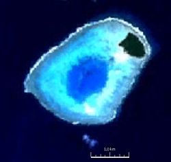
Gewässer Pazifischer Ozean
Archipel Reef Islands
Geographische Lage 10° 6′ S, 166° 2′ O-10.094444444444166.03916666667Koordinaten: 10° 6′ S, 166° 2′ O
Nukapu (Salomonen)
Nukapu
Anzahl der Inseln 1
Hauptinsel Nukapu Island
Länge 3,2 km
Breite 2,2 km
Landfläche 30 ha
Lagunenfläche 70 ha
Gesamtfläche 5,5 km²
Einwohner 100

Nukapu ist ein kleines Atoll in der südöstlichen Provinz Temotu der Salomonen. Es gehört zu den äußeren Inseln der Reef Islands, nördlich der Inselgruppe der Santa-Cruz-Inseln.

Das Atoll hat eine Gesamtfläche von über fünf Quadratkilometern. Von Nordost nach Südwest erstreckt es sich über 3,2 km, bei einer maximalen Breite von 2,2 km. Im Zentrum liegt eine kleine Lagune, die rund 70 Hektar groß ist. Die einzige Insel des Atolls, Nukapu Island, liegt im Nordosten. Die Insel hat eine Größe von 770 mal 650 Metern und eine Fläche von rund 30 Hektar. Der größte Teil des Atolls wird von der Riffplattform eingenommen.

Im Südwesten der Insel, an der rund 70 Hektar kleinen Lagune, liegt das einzige Dorf Nipwa, mit etwa 100 Einwohnern[1]. Auf aktuellen Satellitenbildern sind rund 25 Hütten sowie ein größeres Gebäude zu erkennen.[2]

Einzelnachweise

  1. David Harcombe: Solomon Islands. A travel survival kit. Lonely Planet, South Yarra u. a. 1988, ISBN 0-86442-009-9, S. 227.
  2. Satellitenbild des Dorfes Nipwa auf Nukapu

Wikimedia Foundation.

Игры ⚽ Нужно сделать НИР?

Schlagen Sie auch in anderen Wörterbüchern nach:

  • Nukapu — NASA picture of Nukapu Island Nukapu is one of the islands of the nation of Solomon Islands. It is in the Reef Islands group in Temotu Province; the easternmost province of the Solomons. The island contains a memorial to Bishop John Patteson who… …   Wikipedia

  • Nukapu Expedition — Nukapu, circa 1870. Date October 1871 February 1872 …   Wikipedia

  • Îles Reef — 10°15′S 166°10′E / 10.25, 166.167 Les îles Reef sont un archipel de seize îles dans la province de Temotu au …   Wikipédia en Français

  • John Coleridge Patteson — Infobox Saint name= John Coleridge Patteson birth date = 1 April 1827 death date = 20 September 1871 feast day= 20 September venerated in= Anglican Communion caption=John Coleridge Patteson birth place= England death place = Nukapu, Solomon… …   Wikipedia

  • Matema Island — or Matema is of one of the Reef Islands, of the independent nation of the Solomon Islands; it is located in Temotu Province. The language spoken on Matema Island is Pileni, which is a member of the Polynesian language family. Pileni is also… …   Wikipedia

  • Reef Islands (Salomonen) — Reef Islands NASA Austronautenbild der Reef Islands (Anm.: Norden ist rechts im Bild.) Gewässer …   Deutsch Wikipedia

  • September 20 — Events* 451 The Battle of Chalons takes place in North Eastern France. Flavius Aetius s victory over Attila the Hun in a day of combat, is considered to be the largest battle in the ancient world. *1187 Saladin begins the Siege of Jerusalem.… …   Wikipedia

  • New Georgia Islands — Solomon Islands New Georgia Islands The …   Wikipedia

  • New Georgia — Islands with main centres Geography …   Wikipedia

  • Duff Islands — The Duff Islands (Pileni Taumako) are a small island group lying to the northeast of the Santa Cruz Islands in the Solomon Islands province of Temotu. They are also sometimes known as the Wilson Islands …   Wikipedia

Share the article and excerpts

Direct link
Do a right-click on the link above
and select “Copy Link”