- Paint Creek (Ohio)
-
Paint Creek (Ohio) 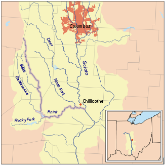
Der Paint Creek innerhalb des Scioto-River-Einzugsgebiets.
Daten Gewässerkennzahl US: 1066883 Lage südlich zentraler Bundesstaat Ohio, USA Flusssystem Mississippi River Abfluss über Scioto River → Ohio River → Mississippi River → Golf von Mexiko Ursprung 7 km westlich von London im südwestlichen Madison County, OH
39° 52′ 17″ N, 83° 33′ 16″ W39.8714489-83.5543663347Quellhöhe 347 m[1] Mündung Scioto River, 4 km südöstlich von Chillicothe im mittleren Ross County. OH 39.2953428-82.9332329179Koordinaten: 39° 17′ 43″ N, 82° 56′ 0″ W
39° 17′ 43″ N, 82° 56′ 0″ W39.2953428-82.9332329179Mündungshöhe 179 m[1] Höhenunterschied 168 m Länge 152,5[2] Einzugsgebiet 2.963 km²[2] Rechte Nebenflüsse Rattlesnake Creek, Sugar Creek, Rocky Fork Paint Creek, East Fork Paint Creek Linke Nebenflüsse North Fork Paint Creek Durchflossene Stauseen Paint Creek Lake  Der Paint Creek bei Greenfield.
Der Paint Creek ist ein 152,5 km langer rechter Nebenfluss des Scioto River im südlich-zentralem US-Bundesstaat Ohio. Er entwässert ein Gebiet von 2.960 km² und gehört zum Flusssystem des Mississippi River. Der Abfluss erfolgt über den Scioto River, Ohio River und Mississippi River in den Golf von Mexiko.[2]
Der Paint Creek entspringt im südwestlichen Madison County, rund 7 Kilometer westlich der Ortschaft London. Er fließt zunächst süd-südwestlich durch das Fayette County und danach an der Grenze der Countys Highland und Ross nach Süden. Südlich der Stadt Greenfield wird der Paint Creek durch einen Damm aufgestaut und bildet den Paint Creek Lake, der sich im Paint Creek State Park befindet. Beim Austritt aus dem See biegt der Fluss nach Osten, durchfließt das Ross County und mündet 4 km südöstlich von Chillicothe in den Scioto River.
Die wichtigsten Nebenflüsse sind der 75 km lange North Fork Paint Creek[3] und der 68 km lange Rattlesnake Creek[4]. Dem Geographic Names Information System zufolge hieß der Fluss im Verlauf seiner Geschichte auch Alamoneetheepeece, Olomon Sepung, Chilicotha Creek, Pain Creek und Pait Creek.[5]
Einzelnachweise
- ↑ a b Google Earth Höhenlage für GNIS-Koordinaten, abgerufen am 26. August 2010.
- ↑ a b c Gazetteer of Ohio Streams, abgerufen am 26. August 2010
- ↑ Paint Creek (Ohio) im Geographic Names Information System des United States Geological SurveyNorth Fork
- ↑ Paint Creek (Ohio) im Geographic Names Information System des United States Geological SurveyRattlesnake Creek
- ↑ Paint Creek (Ohio) im Geographic Names Information System des United States Geological Survey
Weblinks
Kategorien:- Flusssystem Ohio River
- Fluss in Ohio
- Fluss in Nordamerika


Wikimedia Foundation.