Parry Channel

Parry Channel
Parry Channel
Verbindet Gewässer Baffin Bay
mit Gewässer Beaufortsee
Trennt Landmasse Königin-Elisabeth-Inseln
von Landmasse Südliche Inseln des kanadisch-arktischen Archipels
Daten

Geographische Lage

74° N, 93° W74.333333333333-93Koordinaten: 74° N, 93° W
Karte von Parry Channel
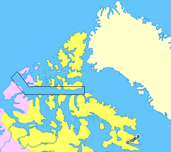
Länge 1.000 km
Geringste Breite 45 km
Küstenorte Resolute Bay

Der Parry Channel (deutsch „Parry-Kanal“) ist eine rund 1000 km lange Meeresstraße in der kanadischen Arktis. Sie verbindet als Teil der Nordwestpassage die Baffin Bay (Atlantischer Ozean) im Osten mit der Beaufortsee (Arktischer Ozean) im Westen und durchquert dabei das Territorium Nunavut sowie das Nordwest-Territorium. Von Osten nach Westen setzt sich der Parry Channel aus dem Lancaster Sound, der Barrow Strait, dem Viscount Melville Sound und der McClure Strait zusammen. Die Straße trennt dabei die Königin-Elisabeth-Inseln im Norden von zahlreichen Inseln des kanadisch-arktischen Archipels im Süden. An der schmalsten Stelle, zwischen Cornwallis Island und Somerset Island hat der der Parry Channel eine Breite von etwa 45 Kilometern.

Benannt ist die Meerenge nach dem britischen Admiral und Polarforscher William Edward Parry, der auf der Suche nach der Nordwestpassage viele Gewässer und Inseln in der Arktis entdeckte.

Weblinks


Wikimedia Foundation.

Игры ⚽ Поможем решить контрольную работу

Schlagen Sie auch in anderen Wörterbüchern nach:

  • Parry Channel — The Parry Channel (coord|74|19|60|N|93|0|0|W) is a natural waterway through thecentral Canadian Arctic Archipelago in the territory of Nunavut. It runs east to west, connecting Baffin Bay in the east with the Beaufort Sea in the west. [cite web… …   Wikipedia

  • Parry — ist der Nachname folgender Personen: Bill Parry (1934–2006), britischer Mathematiker Caleb Hillier Parry (1755–1822), englischer Arzt Charles Christopher Parry (1823–1890), amerikanischer Biologe David Parry (* 1949), britischer Dirigent Edward… …   Deutsch Wikipedia

  • Parry Gripp — Birth name Parry Gripp Born September 22, 1967 (1967 09 22) (age 44) Santa Barbara, California Genres Rock Occupations …   Wikipedia

  • Parry Sound, Ontario — Parry Sound   Town   Looking over the town and the sound …   Wikipedia

  • Parry Sound, Unorganized, Centre Part, Ontario — Parry Sound, Unorganized, Centre Part is an unorganized area in central Ontario, Canada between Georgian Bay and Lake Nipissing in the District of Parry Sound. It is made up of geographic townships which have no governing bodies and which are not …   Wikipedia

  • Parry Sound District, Ontario — Infobox Settlement official name = Parry Sound District other name = native name = nickname = settlement type = District motto = imagesize = image caption = flag size = image seal size = image shield = shield size = city logo = citylogo size =… …   Wikipedia

  • Channel Four/MOMI animator in residence — History= The Channel Four/MOMI animator in residence scheme was housed in the MOMI on the Southbank. Starting in 1990. It ran for thirteen years commissioning over forty films which were transmitted throughout the World. The scheme was the… …   Wikipedia

  • Goldsmith Channel — (coord|73|15|N|106|0|W) is a waterway in the Canadian territory of Nunavut connecting Parry Channel and McClintock Channel. Broadest in the northwest, the island filled channel narrows as it progresses to the southeast where it separates… …   Wikipedia

  • Bruce Parry — Infobox Celebrity name = Bruce Parry caption = birth date = Birth date and age|1969|3|17|df=yes birth place = Hythe, Hampshire, England occupation = Television presenter, Anthropologist salary = networth = spouse = website = footnotes = children …   Wikipedia

  • Crawford Lake (Parry Sound District, Ontario) — Crawford Lake Location Magnetawan, Parry Sound District, Ontario Coordinates …   Wikipedia

Share the article and excerpts

Direct link
Do a right-click on the link above
and select “Copy Link”