Prebbleton

Prebbleton
Prebbleton
Prebbleton (Neuseeland)
Prebbleton
Koordinaten 43° 35′ S, 172° 31′ O-43.578333333333172.51333333333Koordinaten: 43° 35′ S, 172° 31′ O
Einwohner 3.024 (2006)
Region Canterbury
Distrikt Selwyn-Distrikt

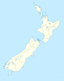
Prebbleton ist ein Ort im Selwyn-Distrikt in der Region Canterbury auf der Südinsel von Neuseeland. Er liegt in den Canterbury Plains etwa neun Kilometer südwestlich von Christchurch an der Springs Road Richtung Lincoln.

Der Ort wurde 1855 gegründet, als sich die Gebrüder Prebble dort ansiedelten.[1] Seit jeher landwirtschaftlich geprägt, befinden sich in der näheren Umgebung zahlreiche Obstgärten und Olivenhaine.

Beim Zensus 2006 betrug die Einwohnerzahl 3.024, was einem Bevölkerungswachstum von 64,7% seit dem vorherigen Zensus im Jahre 2001 entspricht.[2]

Weblinks

Selwyn District, Prebbleton

Quellen

  1. The Cyclopedia of New Zealand
  2. Statistics New Zealand, Prebbleton

Wikimedia Foundation.

Игры ⚽ Нужно сделать НИР?

Schlagen Sie auch in anderen Wörterbüchern nach:

  • Southbridge Branch, New Zealand — The Southbridge Branch was a branch line railway that formed part of New Zealand s national rail network. It was located in the Canterbury region of the South Island and operated from 1875 until 1967. A small portion of the line remains open as… …   Wikipedia

  • New Zealand State Highway 73 — State Highway 73 Great Alpine Highway, Christchurch Ring Road Route information Maintained by …   Wikipedia

  • Ferrymead Railway — The Ferrymead Railway is a New Zealand heritage railway built upon the formation of New Zealand s first public railway, the line from Ferrymead to Christchurch, which opened in 1863. On the opening of the line to Lyttelton on 9 December 1867, the …   Wikipedia

  • Urban areas of New Zealand — Statistics New Zealand defines New Zealand urban areas for statistical purposes. The urban areas comprise cities, towns and other conurbations (an aggregation or continuous network of urban communities) of a thousand people or more. In… …   Wikipedia

  • Christchurch — This article is about the city in New Zealand. For other uses, see Christchurch (disambiguation). Christchurch Ōtautahi (Māori)   Metropolitan Area   Christchurch …   Wikipedia

  • Darfield, New Zealand — …   Wikipedia

  • Ferrymead Heritage Park — is a historical museum in Christchurch, New Zealand, housing a number of groups with historical themes, the most frequent of which is transport. Formerly known as Ferrymead Historic Park, it was founded in the mid 1960s by a number of groups,… …   Wikipedia

  • Craigieburn, New Zealand — This article is about Craigieburn in New Zealand. For Craigieburn, a suburb of Melbourne in Australia, see Craigieburn, Victoria. Craigieburn is the name of several geographic features in northwest Canterbury, in New Zealand s South Island. The… …   Wikipedia

  • Lake Coleridge — Location Selwyn District, Canterbury Region, South Island Coordinates …   Wikipedia

  • Canterbury Rugby Football Union — Rugby team teamname = Canterbury Rugby Union | nickname = Red and Blacks (unofficial) founded = 1879 ground = AMI Stadium (formerly Jade Stadium; Lancaster Park) capacity = 36,500 coach = flagicon|New Zealand Rob Penney chairman =flagicon|New… …   Wikipedia

Share the article and excerpts

Direct link
Do a right-click on the link above
and select “Copy Link”