- Pymatuning State Park (Pennsylvania)
-
 Bootshafen im Pymatuning State Park
Der Pymatuning State Park ist mit 21122 acres der größte State Park im US-Bundesstaat Pennsylvania. Er besteht aus dem aufgestauten Pymatuning Reservoir mit 13716 acres Wasserfläche und 7406 acres Landfläche mit ausgedehnten Uferzonen auf einer Höhe von 308 m[1]. Mit 4,5 Millionen Besuchern pro Jahr ist der im Crawford County liegende Park der meistbesuchte des Staates. Die an der Ostseite angrenzenden Ufer- und Seebereiche im US-Bundesstaat Ohio gehören zum kleineren gleichnamigen Pymatuning State Park (Ohio) und sind hier nicht mitgerechnet.
Am See liegen mehrere Wanderwege, Campingplätze, Badestrände, Bootshäfen, teilweise mit Bootverleih, sowie Angel- und Jagdgebiete. Im Nördlichen Teil befinden sich zwei Natural Areas, die Blackjack Swamp Natural Area und Clark Island[2]. Ein Wasservogel-Museum[3] und eine Fischzuchtanlage[4] sind ebenso vorhanden[5] wie das Pymatuning Laboratory of Ecology der University of Pittsburgh[6].
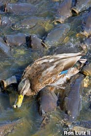
 Where the Ducks Walk on the Fish Hungrige Karpfen
Den östlichen Teil des Sees durchquert ein Fahrdamm der sich an dem Überlaufbauwerk, der die beiden Seeteile verbindet zu einer besonderen Touristenattraktion entwickelt hat, deren Besucherzahlen in Pennsylvanien nur durch die Liberty Bell übertroffen wird. Auf dem Fahrdamm gibt es Parkplätze, ein Restaurant, und eine Verkaufstelle für Brot, das verfüttert werden kann. Am unteren Teil des Überlaufs sammeln sich die Karpfen, die dort von Besucher gefüttert werden, in so großer Anzahl Kopf an Kopf, dass die Enten auf ihnen herumspazieren könnten (Where the Ducks Walk on the Fish) [7][8].
Einzelnachweise
- ↑ http://geonames.usgs.gov/pls/gnispublic/f?p=gnispq:3:185339180882527::NO::P3_FID:1199345
- ↑ http://www.dcnr.state.pa.us/stateparks/parks/pymatuning.aspx
- ↑ http://www.pgc.state.pa.us/pgc/cwp/view.asp?a=487&q=153219
- ↑ http://www.fish.state.pa.us/images/fisheries/fcs/linesville/fcs.htm
- ↑ http://www.dcnr.state.pa.us/news/resource/res2005/05-0830-pymatuningsp.aspx
- ↑ http://www.pitt.edu/~biohome/Dept/Frame/pymatuninghome.htm
- ↑ http://www.roadsideamerica.com/story/2204
- ↑ http://www.roadsideamerica.com/attract/images/pa/PALINfish3_lutz.jpg
Weblinks
41.616944444444-80.399722222222Koordinaten: 41° 37′ 1″ N, 80° 23′ 59″ WKategorien:- State Park in den Vereinigten Staaten
- Geographie (Pennsylvania)


Wikimedia Foundation.