Rempang

Rempang
Rempang
Barelang-Brücke zwischen Batam, Rempang und Galang (2007)
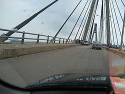
Gewässer Südchinesisches Meer
Inselgruppe Riau-Inseln
Geographische Lage 0° 42′ 0″ N, 104° 13′ 0″ O0.7104.21666666667150Koordinaten: 0° 42′ 0″ N, 104° 13′ 0″ O
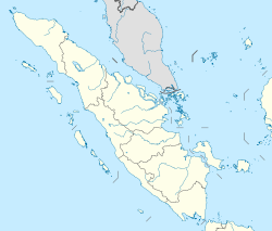
Rempang (Sumatra)
Rempang
Fläche 153,6dep1
Höchste Erhebung 150 m
Rempang und Nachbarinseln

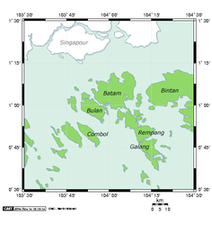
Rempang (indonesisch Pulau Rempang) gehört zu den indonesischen Riau-Inseln vor der Ostküste Sumatras im Indonesischen Archipel.

Geografie

Rempang liegt nördlich von Galang, westlich von Combol und Citlim sowie südlich von Batam und Bintan. Die Fläche der Insel umfasst 153,6 km², ihre Küstenlinie 78,8 km. Die höchste Erhebung beträgt 150 m [1].

Zusammen mit den Nachbarinseln bildet sie die Inselgruppe Barelang (abgekürzt aus Batam-Rempang-Galang).

Die Stadt Airnanti liegt im Norden, Sembulang im Südosten. Zahlreiche kleinere Inseln lagern sich besonders an der Nordküste an.

Verkehr

Die 1997 errichtete und 385 m lange Barelang-Brücke verbindet Rempang mit der südlichen Nachbatinsel Galang [2].

Die Straße Il. Trans Barelang verbindet Rempang mit der nördlichen Nachbarinsel Batam über einige Straßenbrücken zu kleineren Inseln: von Rempang nach Setoko (365 m lang) [3] von Setoko nach Nipah (270 m) [4] , von Nipah nach Tonton (420 m, 1997 fertiggestellt) [5] und von Tonton nach Batam (644 m und ebenfalls 1997 fertiggestellt [6].

Rempang ist mit der Fähre in einer halben Stunde von Tanjung Pinang auf Bintan erreichbar.

Quellen

  1. http://islands.unep.ch/IHB.htm#638
  2. http://de.structurae.de/structures/data/index.cfm?ID=s0003516
  3. http://de.structurae.de/structures/data/index.cfm?ID=s0008075
  4. http://de.structurae.de/structures/data/index.cfm?ID=s0008074
  5. http://de.structurae.de/structures/data/index.cfm?ID=s0004149
  6. http://de.structurae.de/structures/data/index.cfm?id=s0000633

Wikimedia Foundation.

Игры ⚽ Нужно решить контрольную?

Schlagen Sie auch in anderen Wörterbüchern nach:

  • Rempang — is an island, located 2,5 km South East of Batam,165.83 km². [ [http://www.batam.go.id/home/eng/data geografis.php Bida Website ] ] belonging to a group of three islands called Barelang (an abbreviation of Batam Rempang Galang) A member of the… …   Wikipedia

  • Barelang Bridge — The Barelang Bridge ( Jembatan Barelang ) is a chain of 6 bridges of various types that connect the islands of Batam, Rempang, and Galang, giving the system its name. The smaller islands of Tonton, Nipah, and Setotok (considered as parts of the… …   Wikipedia

  • Galang Island — Galang (Indonesian: Pulau Galang), is a island, 80 km2 located 350 m southeast of Batam, [ [http://www.batam.go.id/home/eng/data geografis.php Bida Website ] ] belonging to a group of three islands called Barelang (abbreviation of Batam Rempang… …   Wikipedia

  • List of current ships of the Indonesian Navy — All the Navy Vessels are named with the KRI Initial. KRI (Kapal Perang Republik Indonesia) means Navy Vessel Of The Republic Of Indonesia. The class are often named after the lead ships. Naval Jack of Indonesia The navy includes Frigates,… …   Wikipedia

  • Batam — Vorlage:Infobox Insel/Wartung/Höhe fehlt Batam Hauptstadt Nagoya Gewässer Südchinesisches Meer …   Deutsch Wikipedia

  • Galang — Vorlage:Infobox Insel/Wartung/Bild fehltVorlage:Infobox Insel/Wartung/Höhe fehlt Galang Gewässer Südchinesisches Meer Inselgruppe Riau Inseln Geographische Lage …   Deutsch Wikipedia

  • Batam — Carte de Batam et des îles proches (projection de Mercator) Une rue de Batam L’î …   Wikipédia en Français

  • Hang Nadim Airport — Batam Carte de Batam et des îles proches (projection de Mercator) …   Wikipédia en Français

  • WIDD — Batam Carte de Batam et des îles proches (projection de Mercator) …   Wikipédia en Français

  • Île de Batam — Batam Carte de Batam et des îles proches (projection de Mercator) …   Wikipédia en Français

Share the article and excerpts

Direct link
Do a right-click on the link above
and select “Copy Link”