- Rivière Bell
-
Rivière Bell 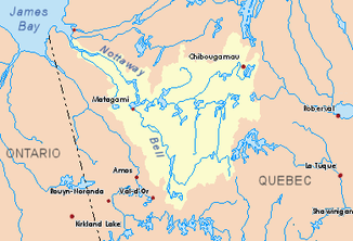
Verlauf des Flusses Rivière Bell im Einzugsgebiet von Rivière Nottaway
Daten Lage Regionen Abitibi-Témiscamingue und Jamésie in der Provinz Québec (Kanada) Flusssystem Rivière Nottaway Abfluss über Lac Matagami → Rivière Nottaway → James Bay Quelle Lac Tiblemont und Lac Pascalis
48° 13′ 59″ N, 77° 19′ 15″ W48.23306-77.32083Mündung Lac Matagami 49.81278-77.65527Koordinaten: 49° 48′ 46″ N, 77° 39′ 19″ W
49° 48′ 46″ N, 77° 39′ 19″ W49.81278-77.65527Länge 240 km[1] Einzugsgebiet 22.222 km²[1] Abflussmenge
am Pegel an der Mündung[2]MNQ: 98 m³/s
MQ: 389 m³/s
MHQ: 1.059 m³/sRechte Nebenflüsse Rivière Mégiscane Durchflossene Seen Lac Parent Der Fluss Rivière Bell fließt durch die Regionen Abitibi-Témiscamingue und Jamésie in der kanadischen Provinz Québec.
Inhaltsverzeichnis
Geographie
Der Fluss entspringt in den Seen Lac Tiblemont und Lac Pascalis in Abitibi. Er wendet sich nach Norden, passiert Senneterre und nimmt anschließend das Wasser des Nebenflusses Rivière Mégiscane auf. Schließlich mündet er nach 240 km bei der Siedlung Rivière-Bell und dem Ort Matagami in den See Lac Matagami. Dessen Abfluss bildet der Fluss Rivière Nottaway, welcher zur James Bay fließt. Der Fluss Rivière Bell hat ein Einzugsgebiet von 22222 km². Es liegen zahllose Stromschnellen an seinem Flusslauf. Die großen Inseln Canica und Bancroft liegen nahe der Flussmündung.[1]
Wichtige Nebenflüsse
Toponymie
Der Fluss wurde nach dem Geologen Robert Bell (1841-1917), der den Fluss 1896 befuhr, benannt.[1]
Einzelnachweise
- ↑ a b c d - Commission de toponymie - Québec - Rivière Bell
- ↑ R-ArcticNet - BELL (RIVIERE) EN AMONT DU LAC MATAGAMI
Weblinks
- R-ArcticNet - BELL (RIVIERE) A SENNETERRE-1
- R-ArcticNet - BELL (RIVIERE) A SENNETERRE-3
- R-ArcticNet - BELL (RIVIERE) A SENNETERRE-4
Kategorien:- Flusssystem Rivière Nottaway
- Fluss in Québec
- Fluss in Nordamerika

Wikimedia Foundation.