- Sennen (Cornwall)
-
50.066666666667-5.6833333333333Koordinaten: 50° 4′ N, 5° 41′ W
Sennen 

Sennen Lage von Sennen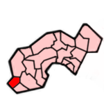 Lage im ehemaligen District Penwith
Basisdaten Status Civil Parish Region South West England Zerem. Grafschaft Cornwall Trad. Grafschaft Cornwall Verwaltungssitz Sennen Einwohner 660 (2000) Postleitzahl TR19 7xx Telefonvorwahl 01736 Teilorte Sennen Cove, Skewjack, Escalls, Trevescan Website -  Abenddämmerung in Sennen Cove
Sennen (kornisch: San Senan) ist eine etwa 9 km² große Gemeinde und ein Ort im ehemaligen District Penwith der Grafschaft Cornwall in England. Die Gemeinde umfasst die Orte Sennen mit der Siedlung Sennen Cove, Trevescan, Carn Towan sowie Land's End und liegt etwa 13 km westlich von Penzance. Sie liegt am Atlantik und grenzt an die Gemeinde St Just in Penwith im Norden, an St Levan im Süden und an St Buryan im Osten. Der Ort Sennen ist der westlichste des englischen Festlands. Erreichbar ist er über die Schnellstraße A30 weniger als 2 km von Land's End entfernt. Der Ort besitzt eine bekannte Bucht mit Sandstrand (Sennen Cove), die auch ein beliebtes Surf-Revier ist.
Siehe auch
 Commons: Sennen – Sammlung von Bildern, Videos und Audiodateien
Gwinear-Gwithian | Hayle | Ludgvan | Madron | Marazion | Morvah | Paul | Penzance | Perranuthnoe | Sancreed | Sennen | St Buryan | St Erth | St Hilary | St Ives | St Just in Penwith | St Levan | St. Michael’s Mount | Towednack | Zennor
Wikimedia Foundation.
Schlagen Sie auch in anderen Wörterbüchern nach:
Sennen — ( Cornish: Sen Senan ) is a village and civil parish, in the Penwith district of Cornwall, United Kingdom. The parish encompasses the settlements of Trevescan, Carn Towan and Sennen as well as Land s End and is bounded by the parishes of St. Just … Wikipedia
Sennen — bezeichnet Sennen (Cornwall), eine Ortschaft in England einen persischen Märtyrer, siehe Abdon und Sennen. einen deutschen Namen für die französische Gemeinde Cernay (Haut Rhin). einen deutschen Namen für den ehemals lettischen Ort/Hof Sänna, der … Deutsch Wikipedia
Sennen Cove — (gbmapping|SW352261) is a small coastal settlement in the parish of Sennen, in the Penwith district of Cornwall, United Kingdom. According to the Penwith District Council, the population of this settlement was estimated at 180 persons in 2000. [… … Wikipedia
Cornwall — 50.297261 4.899737 Koordinaten: 50° 17′ 50″ N, 4° 53′ 59″ W Cornwall … Deutsch Wikipedia
Hundreds of Cornwall — Cornwall was originally divided into hundreds, some with the suffix shire as in Pydershire, East and West Wivelshire and Powdershire which were first recorded as names between 1184 1187. [Gover,1946, Research paper at the Courtney Library, Royal… … Wikipedia
List of topics related to Cornwall — This is a list of topics related to Cornwall, United Kingdom. The contains a more comprehensive selection of Cornish articles.Architecture*Royal Albert Bridge *Tamar Bridge * *Cornwall Railway viaducts *Tate St Ives *Eden Project *Jamaica Inn… … Wikipedia
List of places in Cornwall — This is a list of all the towns and villages of Cornwall, United Kingdom. This also includes places in the Isles of Scilly. See List of places in England for lists of settlements in other counties. Top 15 places by population Alphabetical list A… … Wikipedia
Civil parishes in Cornwall — A map of Cornwall (Cornish: Kernow); the Isles of Scilly (Cornish: Enesek Syllan) are in the extreme bottom left. A civil parish is a subnational entity, forming the lowest unit of local government in Engla … Wikipedia
Christianity in Cornwall — Remains of St Piran s Old Church, Perranzabuloe … Wikipedia
St Hilary, Cornwall — Coordinates: 50°07′50″N 5°25′40″W / 50.13044°N 5.427820°W / 50.13044; 5.427820 … Wikipedia
Sennen (Cornwall)


18+
© Academic, 2000-2024
- Kontaktieren Sie uns: Unterstützung, Werbung
Wörterbücher Export, schritte mit PHP, Joomla, Drupal, WordPress, MODx.