South Andaman Island

South Andaman Island

Vorlage:Infobox Insel/Wartung/Bild fehlt

South Andaman Island
Gewässer Indischer Ozean
Inselgruppe Andamanen
Geographische Lage 11° 54′ N, 92° 40′ O11.992.666666666667456.6Koordinaten: 11° 54′ N, 92° 40′ O
South Andaman Island (Indien)
South Andaman Island
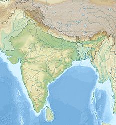
Länge 93 km
Breite 31 km
Fläche 1.347,7 km²
Höchste Erhebung Koiob
456,6 m
Einwohner 181.949 (2001)
135 Einw./km²
Hauptort Port Blair
Lage von South Andaman Island

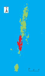
South Andaman Island ist die südlichste der drei großen Hauptinseln der Andamanen im Indischen Ozean. Politisch gehört die Insel zum indischen Unionsterritorium Andamanen und Nikobaren.

Geographie

South Andaman Island liegt unmittelbar südlich von Middle Andaman Island, von dem es nur durch eine wenige Hundert Meter breite Meerenge getrennt ist, sowie nördlich von Rutland Island. Die Insel ist 93 km lang, bis zu 31 km breit und weist eine Fläche von knapp 1348 km²[1] auf. Sie ist weniger bergig als die Inseln im Norden der Andamanen und erreicht im Koiob eine Höhe von 456,6 m über dem Meer.[2] Größte Stadt der Insel ist Port Blair an der Südostküste mit mehr als 100.000 Einwohnern, die zugleich auch Hauptstadt des Unionsterritoriums ist. Zum Stand der Volkszählung 2001 hatte die Insel insgesamt 181.949 Einwohner.[3]

Bevölkerung

An der Westküste South Andamans leben noch wenige hundert Jarawa, eine indigenen Ethnie der Andamanen, die eine ebenfalls Jarawa genannte Sprache aus der Gruppe der andamanischen Sprachen sprechen. Die überwiegend Mehrheit der Bevölkerung bilden jedoch hauptsächlich vom indischen Festland her eingewanderte Ethnien und deren Nachfahren.

Einzelnachweise

  1. Island-wise Statistical Outline - 2008. SOUTH ANDAMAN ISLAND (PDF; englisch)
  2. Classic Encyclopedia, based on the 11th Edition of the Encyclopedia Britannica, 1991: Andaman Islands
  3. Directorate of Economics and Statistics, Andaman and Nicobar Administration, Port Blair: Statistical Hand Book on Andaman District & Nicobar District 2005-2006 Table - 1.8 Tahsil-wise/Island-wise Population of Inhabited Islands (2001 Census) (Summe aus 133337 im Tahsil Port Blair und 48612 im Tahsil Ferrargunj

Wikimedia Foundation.

Игры ⚽ Нужно решить контрольную?

Schlagen Sie auch in anderen Wörterbüchern nach:

  • South Andaman Island — Infobox Islands name = South Andaman image caption = Outline map of the Andaman Islands, with the location of South Andaman Island highlighted (in red) image size = 150px locator Location map|India|lat=11.783333|long=92.65 map custom = yes native …   Wikipedia

  • South Sentinel Island — is one of the Andaman Islands in the Bay of Bengal. At only 160 hectares it is much smaller than its counterpart, North Sentinel Island and of significantly less interest. South Sentinel is located west of north west of Little Andaman Island in… …   Wikipedia

  • South Button Island National Park — is a national park located in the Andaman and Nicobar Islands off the coast of India, the total area of this protected space is about convert|2|sqmi|km2|0.It is located south west of Havelock Island, roughly 2 hours away by motor boat. One of the …   Wikipedia

  • South Button Island National Park — Parc national de South Button Island Parc national de South Button Island Catégorie II de la CMAP (Parc national) Emplacement Andaman et Nicobar, Inde Superficie 30 000 m2 …   Wikipédia en Français

  • Parc national de south button island — Catégorie II de la CMAP (Parc national) Emplacement Andaman et Nicobar, Inde Superficie 30 000 m2 …   Wikipédia en Français

  • Parc national de South Button Island — Catégorie UICN II (parc national) Emplacement Îles Andaman et Nicobar, Inde Coordonnées …   Wikipédia en Français

  • Andaman and Nicobar Islands — /nik euh bahr , nik euh bahr / a union territory of India, comprising the Andaman and Nicobar island groups in the E part of the Bay of Bengal, SW of Burma. 188,254; 3143 sq. mi. (8140 sq. km). Cap.: Port Blair. * * * Union territory (pop., 2001… …   Universalium

  • Andaman and Nicobar Islands — Infobox Indian Jurisdiction type = union territory state name = Andaman and Nicobar Islands native name = Andaman and Nicobar Islands base base map label = no capital = Port Blair largest city = Port Blair latd = 11.68 longd = 92.77 abbreviation …   Wikipedia

  • Andaman Sea — The Andaman Sea ( my. မုတ္တမ; IPA2|moʊʔtəma̰) is a body of water to the southeast of the Bay of Bengal, south of Myanmar, west of Thailand and east of the Andaman Islands; it is part of the Indian Ocean. It is roughly convert|1200|km|mi| 1 (north …   Wikipedia

  • Andaman Islands — a group of islands of India in the E part of the Bay of Bengal, W of the Malay Peninsula, part of Andaman and Nicobar Islands. 157,821; 2508 sq. mi. (6496 sq. km). * * * ▪ island group, India  island group, Andaman and Nicobar Islands union… …   Universalium

Share the article and excerpts

Direct link
Do a right-click on the link above
and select “Copy Link”