Stawamus Chief Provincial Park
- Stawamus Chief Provincial Park
-

Südgipfel des Stawamus Chief
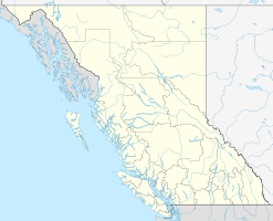
Stawamus Chief Provincial Park ist ein Provincial Park in British Columbia, Kanada. Er liegt am Howe Sound südlich von Squamish am Highway 99. Der Park wurde 1997 errichtet und umfasst eine Fläche von 517 Hektar. Hauptattraktion des Parks ist der Stawamus Chief, ein über 700 Meter hoher Granitmonolith, der über den Howe Sound aufragt. Er wird oft als „zweithöchster Monolith der Welt“ bezeichnet. Seinen Namen hat er nach dem Dorf der First Nations zu seinen Füßen, Sta-a-mus. Für die First Nations ist der Berg von hoher spiritueller Bedeutung.
Der Stawamus Chief ist ein beliebtes Ziel für Bergsteiger, seine steile Westseite ist bei Felskletterern populär. Der Berg hat drei Gipfel, die durch tiefe Einschnitte voneinander getrennt sind. Der Südgipfel ist 602 Meter, der mittlere Gipfel 655 Meter hoch und der Nordgipfel, der höchste Gipfel, erreicht 702 Meter. Alle drei Gipfel sind durch Wege erreichbar, von ihrer baumfreien Granitoberfläche bieten sich jeweils ein prächtiger Ausblick.
Literatur
Weblinks
Kategorie:
- Provincial Park in British Columbia
Wikimedia Foundation.
Schlagen Sie auch in anderen Wörterbüchern nach:
Stawamus Chief Provincial Park — is a provincial park in British Columbia, Canada.It is located just to the south of the town of Squamish, on the Sea to Sky Highway at the top NE corner of the Howe Sound.It encompasses both the Stawamus Chief and the Stawamus Squaw granite domes … Wikipedia
Stawamus Chief — Infobox Mountain Name = Stawamus Chief Photo = Chief RP(2).jpg Caption = Stawamus Chief Elevation = convert|702|m|ft|0|lk=on Location = British Columbia, Canada Range = Pacific Ranges Prominence = convert|417|m|ft|0|abbr=on Coordinates =… … Wikipedia
Shannon Falls Provincial Park — IUCN Kategorie III … Deutsch Wikipedia
Shannon Falls Provincial Park — is a provincial park in British Columbia, Canada. It is located km to mi|58 from Vancouver and km to mi|2 south of Squamish along the Sea to Sky Highway. The park covers an area of 87 hectares. The main point of interest is the third highest… … Wikipedia
Murrin Provincial Park — IUCN Category II (National Park) Browning Lake, summer 2010 Locatio … Wikipedia
Mount Seymour Provincial Park — Mount Seymour Provincial Park. September, 2005 East slopes, looking north toward Mt. Elsay … Wikipedia
Nairn Falls Provincial Park — Location of Nairn Falls Provincial Park in British Columbia Location British Columbia, Canada … Wikipedia
Davis Lake Provincial Park — is a provincial park in British Columbia, Canada. It is located east of the southern end of Stave Lake,[1][2] northeast of Mission, British Columbia. The park s area is c. 185 acres (0.75 km2). There are campgrounds and beaches at the south… … Wikipedia
Mount Elphinstone Provincial Park — is a provincial park in British Columbia, Canada, located around the mountain of the same name on the west side of Howe Sound, just north of the town of Gibsons and just above the community of Roberts Creek. Created in 2000 the park is… … Wikipedia
Duffey Lake Provincial Park — is a provincial park in British Columbia, Canada, located at the lake of the same name, which lies along BC Highway 99 just east of the summit of Cayoosh Pass. The lake s inflow and outflow are Cayoosh Creek. References … Wikipedia