- Tokomairiro River
-
Tokomairiro River 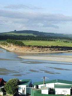
Mündung bei Toko Mouth
Daten Lage Region Otago, Südinsel (Neuseeland) Mündung bei Toko Mouth in den Pazifik -46.219277170.04786Koordinaten: 46° 13′ 9″ S, 170° 2′ 52″ O
46° 13′ 9″ S, 170° 2′ 52″ O-46.219277170.04786Mittelstädte Milton Gemeinden Mount Stuart, Glenore, Clarksville, Toko Mouth  Seegang an der Mündung des Flusses
Der Tokomairiro River ist ein Fluss in der Region Otago auf der Südinsel Neuseelands. Er verläuft für etwas mehr als 50 km in südöstlicher Richtung und erreicht bei Toko Mouth, 50 Kilometer südlich von Dunedin den Pazifik.
Die zweitgrößte Stadt der Region Otago, Milton, liegt in der Flutebene des Tokomairiro. Zwei Hauptarme des Flusses umfassen die Stadt von Süden und Norden.
Der Name des Flusses entstammt aus der Sprache der Māori, und bedeutet Platz wo die Kanus gestakt werden müssen. Das nimmt möglicherweise Bezug auf die in Sumpfgebieten übliche Fortbewegungsweise, wo die üblichen Paddel nicht eingesetzt werden konnten.
Der Fluss neigt in den Regenmonaten August bis Oktober zu Überschwemmungen, daher haben viele Unternehmen ihr Gelände mit hohen Betonmauern umgeben, um die jährlichen Flutschäden zu vermeiden.
Kategorien:- Otago (Region)
- Fluss in Neuseeland


Wikimedia Foundation.