Tuvana-i-Colo

Tuvana-i-Colo

Vorlage:Infobox Insel/Wartung/Höhe fehlt

Tuvana-i-Colo
NASA-Bild von Tuvana-i-Colo (rechts) und Tuvana-i-Ra (links)
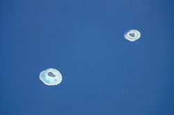
Gewässer Pazifischer Ozean
Geographische Lage 21° 0′ S, 178° 44′ W-20.996666666667-178.73805555556Koordinaten: 21° 0′ S, 178° 44′ W
Tuvana-i-Colo (Fidschi)
Tuvana-i-Colo
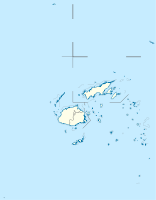
Anzahl der Inseln 1
Länge 1,7 km
Breite 1,65 km
Landfläche 38 ha
Gesamtfläche 2,25 km²
Einwohner (unbewohnt)

Tuvana-i-Colo, vielfach auch als Tuvana-i-Tholo[Anmerkung 1] bezeichnet, ist eine unbewohnte Koralleninsel im Südosten des Inselstaates Fidschi im Pazifischen Ozean. Die 1,7 km lange und knapp 0,4 km²[1] große Insel liegt rund 25 km südlich von Ono-i-Lau, dem südlichsten bewohnten Atoll Fidschis, sowie 8 km ostnordöstlich des Nachbaratolls Tuvana-i-Ra und stellt somit das zweit-südlichste Atoll des Lau-Archipels dar. Sie ist vollständig von einem Saumriff umgeben.

Weblinks

  • Karte Fidschis, auf denen auch Tuvana-i-Colo und Tuvana-i-Ra verzeichnet sind (PDF; englisch)

Anmerkungen

  1. In Fidschi wird das "c" als "th" (wie im englisch "this") ausgesprochen

Einzelnachweise

  1. Coral Reefs of the World, Vol. 3 (Textauszug; englisch)

Wikimedia Foundation.

Игры ⚽ Поможем сделать НИР

Schlagen Sie auch in anderen Wörterbüchern nach:

  • Tuvana-i-Ra — Vorlage:Infobox Insel/Wartung/Höhe fehlt Tuvana i Ra NASA Bild von Tuvana i Ra (links) und Tuvana i Colo (rechts) Gewässer Pazifisc …   Deutsch Wikipedia

  • Mago Island — Coordinates: 17°26′S 179°09′W / 17.433°S 179.15°W / 17.433; 179.15 …   Wikipedia

  • Cicia —   Island   …   Wikipedia

  • Ogea Levu — (pronounced [oˈŋea ˈleβu]) is a coral island on a barrier reef in Fiji s Southern Lau archipelago. With an area of 13.3 square kilometers, it is situated at 19.18° South and 178.47° East, 10 kilometers east of Fulaga. It has a maximum altitude of …   Wikipedia

  • Ogea Driki — (pronounced [oˈŋea ˈndriki]) is a coral atoll (covering approximately 4 square kilometers) in Fiji s Southern Lau Group. It 2.7 kilometers south from Ogea Levu, 10 kilometers east of Fulaga. It is the farming and fishing ground for the Ogean… …   Wikipedia

  • Ono-i-Lau — NASA picture of Ono i Lau. Ono i Lau is a volcanic and coral island in Fiji s Lau archipelago. One of the southernmost of the Lau Islands, it is located at 20.80° South and 178.75° East, and occupies an area of 7.9 square kilometers. It has a… …   Wikipedia

  • Matuku Island — Matuku   Island   …   Wikipedia

  • Moala Islands — The Moala Islands are a subgroup of Fiji s Lau archipelago. Its three islands (Matuku, Moala, and Totoya) are located west of the Lau Islands proper, and were historically linked more closely with Bau Island and Viti Levu than with Lau. They we… …   Wikipedia

  • Namalata — is a village and its own island but is part of the Island Group of Vanua Balavu in Fiji s Lau archipelago. Namalata is part of Lomaloma Tikina. The people of Namalata were the original inhabitants of Mago Island, which is now owned by the actor… …   Wikipedia

  • Lau-Inseln — Karte Fidschis, die Lau Inseln im Südosten Gewässer Korosee Archipel …   Deutsch Wikipedia

Share the article and excerpts

Direct link
Do a right-click on the link above
and select “Copy Link”