Ulungur-See

Ulungur-See
Ulungur-See
Ulungur-See, Satellitenbild
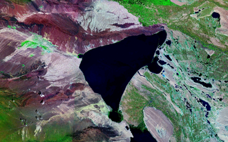
Geographische Lage Xinjiang
Daten
Koordinaten 47° 14′ 58″ N, 87° 19′ 10″ O47.24944444444487.319444444444468Koordinaten: 47° 14′ 58″ N, 87° 19′ 10″ O
Ulungur-See (Xinjiang)
Ulungur-See
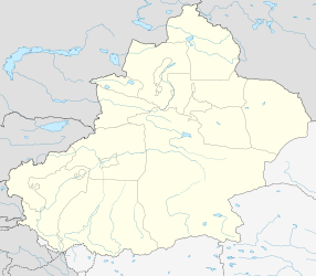
Höhe über Meeresspiegel 468 m
Fläche 827 km²f5

Der Ulungur-See liegt im nördlichen Xinjiang im Distrikt Burultokay und ist der größte See in Norden Chinas und dessen zehntgrößter Trinkwassersee. Er wird vom Fluss Ulungur gespeist, bedeckt insgesamt ein Fläche von 827 Quadratkilometern und liegt auf 468 Höhenmetern. Seit 1969 existiert ein Kanal, der vom Irtysch dem See Wasser zuführt.

Im Nordosten des Sees gibt es etwas Tourismus. An dem zehn Kilometer langen Sandstrand gibt es einige Wassersport-Attraktionen; im Winter gibt es Eisfischen.[1]

An der Südwestküste befindet sich eine Zementfabrik.

Weblinks

Einzelnachweise

  1. http://www.chinatoday.com.cn/lachine/2005/0504/f44.htm Chinatoday (franz.)

Wikimedia Foundation.

Игры ⚽ Нужен реферат?

Schlagen Sie auch in anderen Wörterbüchern nach:

  • Liste chinesischer Seen — Dies ist eine Liste chinesischer Seen. Sie ist untergliedert in Süßwasser und Salzwasserseen. Inhaltsverzeichnis 1 Süßwasserseen 2 Salzwasserseen 3 unsortiert 4 Weblinks …   Deutsch Wikipedia

  • List of rivers of China — This article is about rivers in the areas under the jurisdictions of the People s Republic of China (commonly known as China ). For rivers in the areas under the jurisdiction of the Republic of China (commonly known as Taiwan ), see List of… …   Wikipedia

  • Urungu — / Ulungur Vorlage:Infobox Fluss/KARTE fehlt DatenVorlage:Infobox Fluss/GKZ fehlt …   Deutsch Wikipedia

  • Liste des lacs du monde — Liste de lacs, non exhaustive, ordonnée par continent : Sommaire 1 Afrique 1.1 Lacs partagés entre plusieurs pays 1.2 Algérie 1.3 Congo Kinshasa …   Wikipédia en Français

  • Heaven Lake — Location North Korea / China Coordinates …   Wikipedia

  • Qinghai Lake — From space (November 1994). North is to the left. Location Tibetan Plateau Coordinates …   Wikipedia

  • Lop Nur — Chinese name Traditional Chinese 羅布泊 Simplified Chinese 罗布泊 …   Wikipedia

  • Khanka Lake — Landsat 7 image (2001) Location Heilongjiang province, China and Primorsky Krai, Russia Coordinates …   Wikipedia

  • Namtso — View on the lake and the holy rock near the Tashi Dor monastery (2005) …   Wikipedia

  • Daming Lake — and Jinan skyline Location Jinan Coordinates …   Wikipedia

Share the article and excerpts

Direct link
Do a right-click on the link above
and select “Copy Link”