- Vémars
-
Vémars 

Region Île-de-France Département Val-d’Oise Arrondissement Sarcelles Kanton Gonesse Gemeindeverband Communauté de communes Roissy Porte de France Koordinaten 49° 4′ N, 2° 34′ O49.0666666666672.5666666666667Koordinaten: 49° 4′ N, 2° 34′ O Höhe 96–146 m Fläche 8,18 km² Einwohner 2.075 (1. Jan. 2008) Bevölkerungsdichte 254 Einw./km² Postleitzahl 95470 INSEE-Code 95641 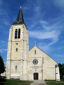
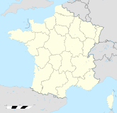
Kirche Saint-Pierre-et-Saint-PaulVémars ist eine französische Gemeinde mit 2075 Einwohnern (Stand 1. Januar 2008) im Département Val-d’Oise, Region Île-de-France etwa 36 Kilometer nordöstlich von Paris; sie gehört zum Arrondissement Sarcelles und zum Kanton Gonesse.
Nachbargemeinden von Vémars sind Saint-Witz, Plailly, Moussy-le-Neuf, Mauregard, Épiais-lès-Louvres, Chennevières-lès-Louvres und Villeron.
Inhaltsverzeichnis
Bevölkerungsentwicklung
Jahr 1962 1968 1975 1982 1990 1999 2007 Einwohner 551 553 844 842 2099 2058 2030 Sehenswürdigkeiten
- Kirche Saint-Pierre-et-Saint-Paul (16. Jahrhundert)
- Schloss La Motte, heute das Rathaus (frz. Mairie)
Persönlichkeiten
- François Mauriac (1885-1970), Schriftsteller, wohnte im Schloss La Motte
Weblinks
 Commons: Vémars – Sammlung von Bildern, Videos und AudiodateienKategorien:
- Gemeinde im Département Val-d’Oise
- Ort in der Île-de-France


Wikimedia Foundation.