Wynoochee Lake

Wynoochee Lake
Wynooche Lake
Schwimmbereich bei der Staumauer
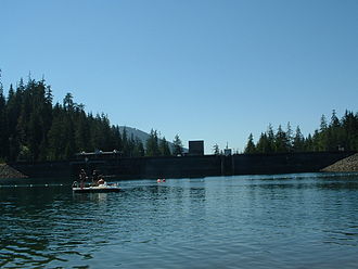
Geographische Lage Grays Harbor County, Washington, USA
Zuflüsse Wynoochee River
Abfluss Wynoochee River
Daten
Koordinaten 47° 23′ 9″ N, 123° 36′ 19″ W47.385833333333-123.60527777778Koordinaten: 47° 23′ 9″ N, 123° 36′ 19″ W
Wynooche Lake (Washington)
Wynooche Lake
Fläche 4,54 km²f5
Länge 6 kmf6
Breite 800 mf7
Volumen 86.000.000 m³f8

Der Wynoochee Lake ist ein kleiner Stausee am oberen Wynoochee River im Grays Harbor County, US-Bundesstaat Washington. Er hat eine Fläche von 4,54 km² und ein nutzbares Stauvolumen von etwa 86 Mio. m³.[1]

Der Wynoochee Dam wurde vom United States Army Corps of Engineers im September 1972 fertiggestellt. Er dient in erster Linie dem Hochwasserschutz und der Wasserversorgung von Industriebetrieben in Aberdeen. Daneben ist der im Olympic National Forest gelegene See ein Erholungsgebiet mit Campingplätzen und Wanderwegen an seinen Ufern. 1994 errichtete Tacoma Power, Teil des öffentlichen Versorgungsunternehmens Tacoma Public Utilities, ein Kraftwerk, dass pro Jahr 30 Mio. kWh Strom erzeugt. [2]

Einzelnachweise

  1. "Wynoochee River", Chehalis River Council (englisch)
  2. Tacoma Power (englisch)

Weblinks


Wikimedia Foundation.

Игры ⚽ Поможем решить контрольную работу

Schlagen Sie auch in anderen Wörterbüchern nach:

  • Wynoochee River — Gewässerkennzahl US: 1528332 Lage Olympic Halbinsel, Washington (USA) Flusssyste …   Deutsch Wikipedia

  • Wynoochee Dam — creating Wynoochee Lake.Tacoma Power added a powerhouse downstream from the dam in 1994. Although access to the dam has been restricted since September 11, 2001, tours are available by appointment.Coho campground, managed by the Olympic National… …   Wikipedia

  • Lake Aberdeen (Washington) — Lake Aberdeen Bild gesucht  BW Geographische Lage Grays Harbor County, Washington, USA …   Deutsch Wikipedia

  • Lake Cowichan First Nation — The Lake Cowichan First Nation government and reserve is located in Lake Cowichan, British Columbia. The Lake Cowichan First Nation, while its own distinct group, is closely linked to the peoples of the Cowichan Tribes band government, and is… …   Wikipedia

  • Olympic Peninsula — The peninsula and Olympic National Park Olympic Coast National Marine Sanctuary …   Wikipedia

  • Water Resources Development Act of 1988 — (WRDA 1988), USPL|100|676, is a public law passed by Congress on November 17, 1988 concerning water resources in the United States in the areas of flood control, navigation, dredging, environment, recreation, water supply, beach nourishment and… …   Wikipedia

  • Grays Harbor County, Washington — Location in the state of Washington …   Wikipedia

  • List of dams and reservoirs in the United States — This list is incomplete; you can help by expanding it. The following is a partial list of dams and reservoirs in the United States. There are an estimated 75,000 dams in the United States, impounding 600,000 mi (970,000 km) of river or about 17%… …   Wikipedia

  • Wedekind Creek — Gewässerkennzahl US: 1511686 Lage Grays Harbor County, Washington, USA Flusssystem …   Deutsch Wikipedia

  • Montesano — Lage von Mont …   Deutsch Wikipedia

Share the article and excerpts

Direct link
Do a right-click on the link above
and select “Copy Link”