- Cochrane District
-
Cochrane District 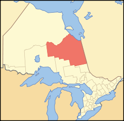
Lage des Cochrane District in OntarioProvinz Ontario Verwaltungssitz Cochrane Fläche 141.243,97 km² Einwohner (2006) 82.503 Bevölkerungsdichte 0,6 Ew./km² Der Cochrane District ist ein Verwaltungsbezirk im Nordosten der kanadischen Provinz Ontario. Hauptort ist Cochrane. Die Einwohnerzahl beträgt 82.503 (2006), die Fläche 141.243,97 km², was einer Bevölkerungsdichte von 0,6 Einwohnern je km² entspricht. Der Bezirk wurde 1921 aus Teilen des Timiskaming District und des Thunder Bay District gebildet.
Gliederung
Gemeinden:
- Black River-Matheson
- Cochrane
- Fauquier-Strickland
- Hearst
- Iroquois Falls
- Kapuskasing
- Mattice-Val Côté
- Moonbeam
- Moosonee
- Opasatika
- Smooth Rock Falls
- Timmins
- Val Rita-Harty
Reservate:
- Abitibi 70
- Constance Lake 92
- Factory Island 1
- Flying Post 73
- Fort Albany 67
- Moose Factory 68
- New Post 69
- New Post 69A
Gemeindefreie Gebiete:
- Cochrane, Unorganized, North Part
- Cochrane, Unorganized, South East Part
- Cochrane, Unorganized, South West Part
Weblinks

Einstufige Gemeinden: Brant | Brantford | Chatham-Kent | Greater Sudbury | Haldimand | Hamilton | Kawartha Lakes | Norfolk | Ottawa | Prince Edward | Toronto
Regionalgemeinden: Durham | Halton | Muskoka | Niagara | Oxford | Peel | Waterloo | York
Countys: Bruce | Dufferin | Elgin | Essex | Frontenac | Grey | Haliburton | Hastings | Huron | Lambton | Lanark | Leeds and Grenville | Lennox and Addington | Middlesex | Northumberland | Perth | Peterborough | Prescott and Russell | Renfrew | Simcoe | Stormont, Dundas and Glengarry | Wellington
Distrikte: Algoma | Cochrane | Kenora | Manitoulin | Nipissing | Parry Sound | Rainy River | Sudbury | Thunder Bay | Timiskaming
Wikimedia Foundation.
Schlagen Sie auch in anderen Wörterbüchern nach:
Cochrane District — District Location of Cochrane District in Ontario … Wikipedia
Cochrane District, Ontario — is a district and census division in Northeastern Ontario in the Canadian province of Ontario. It was created in 1921 from parts of Timiskaming and Thunder Bay districts. The land area of this district is 141,244 km² (54,522 mi²).… … Wikipedia
Cochrane District municipal elections, 2010 — Elections were held in the organized municipalities in the Cochrane District of Ontario on October 25, 2010 in conjunction with municipal elections across the province. Contents 1 Black River Matheson 2 Cochrane 3 Fauquier Strickland … Wikipedia
List of secondary highways in Cochrane District — This is a list of secondary highways in Cochrane District, most of which serve as logging roads, mine and dam access roads, or provide access to isolated and sparsely populated areas in the Cochrane District of northeastern Ontario. Contents 1… … Wikipedia
Unorganized South East Cochrane District — Unorganized Cochrane South East Part Unorganized territory ONT Railway crossing in Bourkes … Wikipedia
Unorganized North Cochrane District — Unorganized Cochrane North Part Unorganized territory Otter Rapids Generating Station on the Abitibi River … Wikipedia
Unorganized South West Cochrane District — Unorganized Cochrane South West Part Unorganized territory … Wikipedia
Crawford Lake (Cochrane District, Ontario) — Crawford Lake Location Cochrane District, Ontario Coordinates … Wikipedia
Cochrane — may refer to: Contents 1 People 2 Places 3 Fiction 4 O … Wikipedia
District De Cochrane (Ontario) — District de Cochrane 50° 28′ 12″ N 83° 00′ 57″ W / 50.470039, 83.015852 … Wikipédia en Français
Cochrane District

18+
© Academic, 2000-2024
- Kontaktieren Sie uns: Unterstützung, Werbung
Wörterbücher Export, schritte mit PHP, Joomla, Drupal, WordPress, MODx.