Corowa Shire

Corowa Shire
Shire of Corowa
Australia-Map-NSW-LGA-Corowa.png
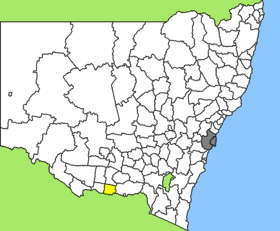
Lage des Corowa Shire in New South Wales
Gliederung
Staat: Australien Australien
Bundesstaat: Flag of New South Wales.svg New South Wales
Verwaltungssitz: Corowa
Daten und Zahlen
Fläche: 2.324 km²
Einwohner: 10.976 (2006) [1]
Bevölkerungsdichte: 4,7 Einwohner je km²
-35.983333333333146.38333333333

Corowa Shire ist ein lokales Verwaltungsgebiet (LGA) im australischen Bundesstaat New South Wales. Das Gebiet ist 2.324 km² groß und hat etwa 10.900 Einwohner.

Corowa liegt im Süden des Staates am Murray River an der Grenze zu Victoria etwa 400 km westlich der australischen Hauptstadt Canberra sowie 610 km südwestlich von Sydney und 300 km nordöstlich von Melbourne. Das Gebiet umfasst 19 Ortsteile und Ortschaften: Brawlin, Carinyah, Cootamundra, Cullinga, Dudauman, Frampton, Gundibindyal, Jindalee, Kilrush, Kyron, Landgrove, Meemar, Morrisons Hill, Stockinbingal, Wallendbeen, Willows, Yannawah, Yeo Yeo und ein Teil von Jugiong. Der Sitz des Shire Councils befindet sich in der Ortschaft Corowa am Murray, wo etwa 5.200 Einwohner leben.

Verwaltung

Der Corowa Shire Council hat zehn Mitglieder, die von den Bewohnern der LGA gewählt werden. Corowa ist nicht in Bezirke untergliedert. Aus dem Kreis der Councillor rekrutiert sich auch der Mayor (Bürgermeister) des Councils.

Weblinks

Einzelnachweise

  1. Australian Bureau of Statistics (25. Oktober 2007): Corowa Shire (A) (Local Government Area) (Englisch). 2006 Census QuickStats. Abgerufen am 6. April 2010.

Wikimedia Foundation.

Игры ⚽ Поможем написать реферат

Schlagen Sie auch in anderen Wörterbüchern nach:

  • Corowa Shire — New South Wales Location in New South Wales Population: 11,685(2009) …   Wikipedia

  • Corowa Shire — Admin ASC 2 Code Orig. name Corowa Shire Country and Admin Code AU.02.12300 AU …   World countries Adminstrative division ASC I-II

  • Corowa Shire Council — Infobox Australian Place | type = lga name = Corowa Shire caption = Location in New South Wales state=New South Wales region=Riverina area=2324 seat=Corowa (Corner Bow Street Honour Avenue)cite web title=Corowa Shire Council publisher =… …   Wikipedia

  • Corowa — New South Wales A view of the main street of Corowa …   Wikipedia

  • Corowa, New South Wales — Infobox Australian Place | type = town name = Corowa state = nsw caption = A view of the main street of Corowa lga = Corowa Shire Council postcode = 2646 pop = 5,628 pop footnotes = census 2006 AUS|id=SSC16843|name=Corowa (State… …   Wikipedia

  • Shire of Moira — Victoria Location in Victoria Population …   Wikipedia

  • Shire of Yarrawonga — Infobox Australian Place | type = lga name = Shire of Yarrawonga state = vic region = area = 626.78 est = 1891 seat = Yarrawonga pop = 5740 (1992) [cite book|title=Victorian Year Book|author=Australian Bureau of Statistics, Victoria… …   Wikipedia

  • Shire of Rutherglen — Infobox Australian Place | type = lga name = Shire of Rutherglen state = vic region = area = 530.9 est = 1862 seat = Rutherglen pop = 3560 (1992) [cite book|title=Victorian Year Book|author=Australian Bureau of Statistics, Victoria… …   Wikipedia

  • Corowa — ▪ New South Wales, Australia  town on the Murray River, New South Wales, Australia. Immediately on the opposite side of the Murray River, in Victoria, is the twin town of Wahgunyah. Corowa was established in 1858. The Corowa Conference in 1893… …   Universalium

  • Shire of Indigo — Infobox Australian Place | type = lga name = Shire of Indigo state = vic caption = Location in Victoria pop = 14,798 (2006 Census) area = 2044 est = seat = Beechworth mayor = Vic Issell region = url = http://www.indigoshire.vic.gov.au/ stategov …   Wikipedia

Share the article and excerpts

Direct link
Do a right-click on the link above
and select “Copy Link”