- Cowra Shire
-
Shire of Cowra 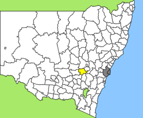
Lage des Cowra Shire in New South WalesGliederung Staat:  Australien
Bundesstaat:  New South Wales
Verwaltungssitz: Cowra Daten und Zahlen Fläche: 2.810 km² Einwohner: 12.475 (2006) [1] Bevölkerungsdichte: 4,4 Einwohner je km² -33.816666666667148.7Koordinaten: 33° 49′ S, 148° 42′ OCowra Shire ist ein lokales Verwaltungsgebiet (LGA) im australischen Bundesstaat New South Wales. Das Gebiet ist 2.810 km² groß und hat etwa 12.500 Einwohner.
Cowra liegt in der Region Central West etwa 200 km nördlich der australischen Hauptstadt Canberra und 330 km westlich der Metropole Sydney. Das Gebiet umfasst 40 Ortsteile und Ortschaften, darunter Billimari, Cowra, Darby Falls, Gooloogong, Morongla, Mount McDonald, Noonbinna, Wattamondara, Woodstock und Teile von Canowindra, Koorawatha und Wyangala. Der Sitz des Shire Councils befindet sich in Cowra, wo etwa 8.400 Einwohner leben.
In Canowindra findet jährlich ein Ballon-Festival, die "Marti¹s Balloon Fiesta" statt, zu der mehr als 20.000 Besucher kommen. Es ist eines der Größten seiner Art in der südlichen Hemisphäre. Der Ort liegt etwa 33 km nördlich von Cowra und nennt sich "Ballooning Capital of Australia".
Verwaltung
Der Cowra Shire Council hat zehn Mitglieder, die von den Bewohnern der LGA gewählt werden. Cowra ist nicht in Bezirke untergliedert. Aus dem Kreis der Councillor rekrutiert sich auch der Mayor (Bürgermeister) des Councils.
Weblinks
Einzelnachweise
- ↑ Australian Bureau of Statistics (25. Oktober 2007): Cowra (A) (Local Government Area) (Englisch). 2006 Census QuickStats. Abgerufen am 6. April 2010.
Kategorie:- Local Government Area in New South Wales

Wikimedia Foundation.