- Dodge County (Wisconsin)
-
 Dodge County Administration Building in Juneau
Verwaltung US-Bundesstaat: Wisconsin Verwaltungssitz: Juneau Adresse des
Verwaltungssitzes:Dodge County Administration Building
127 East Oak Street
Juneau, WI 53039-1329Gründung: 1836 Gebildet aus: Wisconsin-Territorium Vorwahl: 001 920 Demographie Einwohner: 88.759 (2010) Bevölkerungsdichte: 38,8 Einwohner/km² Geographie Fläche gesamt: 2.349 km² Wasserfläche: 64 km² Karte 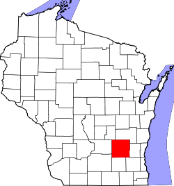
Website: www.co.dodge.wi.us Dodge County[1] ist ein County im Bundesstaat Wisconsin der Vereinigten Staaten von Amerika. Bei der Volkszählung im Jahr 2010 hatte das County 88.759 Einwohner und eine Bevölkerungsdichte von 38,8 Einwohnern pro Quadratkilometer. Der Verwaltungssitz (County Seat) ist Juneau, das nach Paul Juneau, dem Gründer der Stadt benannt wurde.
Inhaltsverzeichnis
Geografie
Das County liegt im mittleren Südosten von Wisconsin, ist im Osten etwa 65 km vom Michigansee entfernt und hat eine Fläche von 2349 Quadratkilometern, wovon 64 Quadratkilometer Wasserfläche sind. Im Dodge County entsteht der Rock River, ein Nebenfluss des Mississippi, durch den Zusammenfluss seiner Quellflüsse.
Das Dodge County grenzt an folgende Countys:
Green Lake County Fond du Lac County Columbia County 
Washington County Dane County Jefferson County Waukesha County Geschichte
 Henry Dodge
Dodge County wurde 1836 als Original-County aus Teilen des Wisconsin-Territoriums gebildet. Benannt wurde es nach Henry Dodge, einem General und frühen Gouverneur des Wisconsin-Territoriums.
Demografische Daten
Historische Einwohnerzahlen Census Einwohner ± in % 1900 46.631 — 1910 47.436 2 % 1920 49.742 5 % 1930 52.092 5 % 1940 54.280 4 % 1950 57.611 6 % 1960 63.170 10 % 1970 69.004 9 % 1980 75.064 9 % 1990 76.559 2 % 2000 85.897 10 % 2010 88.759 3 % 1900–1990[2] 2010[3]  Alterspyramide (2000) des Dodge County
Nach der Volkszählung im Jahr 2000 lebten im Dodge County 85.897 Menschen in 31.417 Haushalten. 22.306 Familien lebten im County. Die Bevölkerungsdichte betrug 38 Personen pro Quadratkilometer. Ethnisch betrachtet setzte sich die Bevölkerung zusammen aus 95,28 Prozent Weißen, 2,49 Prozent Afroamerikanern, 0,40 Prozent amerikanischen Ureinwohnern, 0,34 Prozent Asiaten, 0,03 Prozent Bewohnern aus dem pazifischen Inselraum und 0,87 Prozent aus anderen ethnischen Gruppen; 0,58 Prozent stammten von zwei oder mehr Ethnien ab. 2,55 Prozent der Bevölkerung waren spanischer oder lateinamerikanischer Abstammung, die verschiedenen der genannten Gruppen angehörten.
Von den 31.417 Haushalten hatten 33,9 Prozent Kinder unter 18 Jahren, die mit ihnen zusammen lebten. 59,6 Prozent davon waren verheiratete, zusammenlebende Paare, 7,5 Prozent waren allein erziehende Mütter. 29,0 Prozent waren keine Familien. 24,1 Prozent waren Singlehaushalte und in 10,8 Prozent lebten Menschen mit 65 Jahren oder älter. Die durchschnittliche Haushaltsgröße betrug 2,56 und die durchschnittliche Familiengröße lag bei 3,05 Personen.
24,8 Prozent der Bevölkerung waren unter 18 Jahre alt, 8,3 Prozent zwischen 18 und 24, 31,2 Prozent zwischen 25 und 44, 21,9 Prozent zwischen 45 und 64, und 14,0 Prozent waren 65 Jahre oder älter. Das Durchschnittsalter betrug 37 Jahre. Auf 100 weibliche kamen statistisch 109,7 männliche Personen.[4]
Städte und Gemeinden
- Beaver Dam
- Columbus1
- Fox Lake
- Mayville
- Watertown2
- Waupun3
- Brownsville
- Clyman
- Hustisford
- Iron Ridge
- Kekoskee
- Lomira
- Lowell
- Neosho
- Randolph1
- Reeseville
- Theresa
1 - teilweise im Columbia County
2 - teilweise im Jefferson County
3 - teilweise im Fond du Lac County
4 - teilweise im Washington CountyEinzelnachweise
- ↑ Dodge County im Geographic Names Information System des United States Geological Survey. Abgerufen am 22. Februar 2011
- ↑ Auszug aus Census.gov. Abgerufen am 28. Februar 2011
- ↑ United States Census 2010 Abgerufen am 16. März 2011
- ↑ Dodge County, Wisconsin, Datenblatt mit den Ergebnissen der Volkszählung im Jahre 2000 bei factfinder.census.gov.
Weblinks
-
 Commons: Dodge County, Wisconsin – Sammlung von Bildern, Videos und Audiodateien
 - Offizielle Webseite
- Dodge County Tourism Association
- www.city-data.com

Liste der Countys in Wisconsin
Adams | Ashland | Barron | Bayfield | Brown | Buffalo | Burnett | Calumet | Chippewa | Clark | Columbia | Crawford | Dane | Dodge | Door | Douglas | Dunn | Eau Claire | Florence | Fond du Lac | Forest | Grant | Green | Green Lake | Iowa | Iron | Jackson | Jefferson | Juneau | Kenosha | Kewaunee | La Crosse | Lafayette | Langlade | Lincoln | Manitowoc | Marathon | Marinette | Marquette | Menominee | Milwaukee | Monroe | Oconto | Oneida | Outagamie | Ozaukee | Pepin | Pierce | Polk | Portage | Price | Racine | Richland | Rock | Rusk | Sauk | Sawyer | Shawano | Sheboygan | St. Croix | Taylor | Trempealeau | Vernon | Vilas | Walworth | Washburn | Washington | Waukesha | Waupaca | Waushara | Winnebago | Wood
Wikimedia Foundation.
Schlagen Sie auch in anderen Wörterbüchern nach:
Dodge County, Wisconsin — Location in the state of Wisconsin … Wikipedia
National Register of Historic Places listings in Dodge County, Wisconsin — Buildings, sites, structures, districts, and objects in Dodge County listed on the National Register of Historic Places This National Park Service list is complete through NPS recent listings posted November 10, 2011.[1] … Wikipedia
Oak Grove, Dodge County, Wisconsin — Oak Grove, Wisconsin Town Location of Oak Grove, Wisconsin … Wikipedia
Hubbard, Dodge County, Wisconsin — Infobox Settlement official name = Hubbard, Wisconsin settlement type = Town nickname = motto = imagesize = image caption = image mapsize = 250px map caption = Location of Hubbard, Wisconsin mapsize1 = map caption1 = subdivision type = Country… … Wikipedia
Emmet, Dodge County, Wisconsin — Infobox Settlement official name = Emmet, Wisconsin settlement type = Town nickname = motto = imagesize = image caption = image mapsize = 250px map caption = Location of Emmet, Wisconsin mapsize1 = map caption1 = subdivision type = Country… … Wikipedia
Herman, Dodge County, Wisconsin — Infobox Settlement official name = Herman, Wisconsin settlement type = Town nickname = motto = imagesize = image caption = image mapsize = 250px map caption = Location of Herman, Wisconsin mapsize1 = map caption1 = subdivision type = Country… … Wikipedia
Lebanon, Dodge County, Wisconsin — Infobox Settlement official name = Lebanon, Wisconsin settlement type = Town nickname = motto = imagesize = image caption = image mapsize = 250px map caption = Location of Lebanon, Wisconsin mapsize1 = map caption1 = subdivision type = Country… … Wikipedia
Portland, Dodge County, Wisconsin — Infobox Settlement official name = Portland, Wisconsin settlement type = Town nickname = motto = imagesize = image caption = image mapsize = 250x200px map caption = Location of Portland, Wisconsin mapsize1 = map caption1 = subdivision type =… … Wikipedia
Shields, Dodge County, Wisconsin — Infobox Settlement official name = Shields, Wisconsin settlement type = Town nickname = motto = imagesize = image caption = image mapsize = 250px map caption = Location of Shields, Wisconsin mapsize1 = map caption1 = subdivision type = Country… … Wikipedia
Trenton, Dodge County, Wisconsin — Infobox Settlement official name = Trenton, Wisconsin settlement type = Town nickname = motto = imagesize = image caption = image mapsize = 250px map caption = Location of Trenton, Wisconsin mapsize1 = map caption1 = subdivision type = Country… … Wikipedia
Dodge County (Wisconsin)


18+
© Academic, 2000-2024
- Kontaktieren Sie uns: Unterstützung, Werbung
Wörterbücher Export, schritte mit PHP, Joomla, Drupal, WordPress, MODx.