Agrihan

Agrihan
Agrigan
Satellitenbild von Agrigan
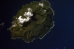
Gewässer Pazifischer Ozean
Inselgruppe Nördliche Marianen
Geographische Lage 18° 46′ 42″ N, 145° 40′ 17″ O18.778333333333145.67138888889965Koordinaten: 18° 46′ 42″ N, 145° 40′ 17″ O
Karte von Agrigan
Länge 9 km
Breite 6 km
Fläche 43,51 km²dep1
Höchste Erhebung 965 m
Einwohner (unbewohnt)

Der Agrigan, auch als Agrihan bezeichnet, ist ein Stratovulkan, welcher die gleichnamige Insel der Nördlichen Marianen im Pazifischen Ozean bildet. Er ist mit 965 m zugleich der höchste der Vulkane des Marianen-Inselbogens. Vom Meeresboden bis zum Gipfel hat der Vulkan eine Gesamt-Höhe von über 4'000 m. Die dicht bewaldete, elliptische Insel ist 9 km lang, bis zu 6 km breit und weist eine Fläche von etwa 44 km² auf. Die Gipfelregion bildet eine 500 m tiefe, 1 x 2 km messende Caldera. Der Caldera-Boden weist einige Lavaströme sowie zwei Vulkankegel auf, welche vermutlich bei der einzigen bekannten Eruption im Jahre 1917 entstanden, bei welcher zudem ein Dorf an der Südostküste evakuiert werden musste.

Weblinks

Wolken über dem Agrihan, Sicht von Süden.

Wikimedia Foundation.

Игры ⚽ Нужно решить контрольную?

Schlagen Sie auch in anderen Wörterbüchern nach:

  • Agrihan —   [æ griːhən], Vulkaninsel der Marianen, bis 965 m über dem Meeresspiegel, 47,4 km2, etwa 25 Einwohner …   Universal-Lexikon

  • Agrihan — Infobox Mountain Name=Agrigan Photo=AgrihanNASA.jpg Caption= NASA Space Shuttle image of Agrihan island. Elevation= 965 m (3,166 ft) Location=Mariana Islands Range = Prominence = Coordinates = coord|18|46|N|145|40|E|type:mountain|display=inline,ti… …   Wikipedia

  • Agrihan — Agrigan Agrigan Agrihan Vue d Agrigan depuis la mer. Géographie Pays …   Wikipédia en Français

  • Agrihan — ▪ island, Northern Mariana Islands formerly  Grigan  or  Agrigan        one of the Mariana Islands and part of the Northern Mariana Islands, a commonwealth of the United States. It lies in the western Pacific Ocean, 350 miles (560 km) north of… …   Universalium

  • Agrihan — Plantilla:Infobox Mountain Agrihan (también llamada Agrigán) es un estratovolcán que forma una isla en las islas Marianas del Norte en el océano Pacífico. Toda la isla es un gran volcán que se eleva unos 4,000 m (13,000 ft) desde… …   Wikipedia Español

  • Agrihan Island — Admin ASC 2 Code Orig. name Agrihan Island Country and Admin Code MP.085.7733404 MP …   World countries Adminstrative division ASC I-II

  • Northern Mariana Islands — This article is about the Commonwealth of the Northern Mariana Islands. For the Mariana Archipelago, see Mariana Islands. Commonwealth of the Northern Mariana Islands Sankattan Siha Na Islas Mariånas …   Wikipedia

  • 2004 Pacific typhoon season — Infobox hurricane season Basin=WPac Year=2004 Track=2004 Pacific typhoon season summary.jpg First storm formed=April 5, 2004 Last storm dissipated=December 21, 2004 Strongest storm name=Chaba Strongest storm pressure=910 Strongest storm winds=110 …   Wikipedia

  • Northern Mariana Islands — group of islands in the W Pacific Ocean, including all of the Mariana Islands except Guam: a commonwealth in association with the U.S. since 1986, it was formerly part of the Trust Territory of the Pacific Islands (as part of the Mariana Islands) …   Universalium

  • Typhoon Kong-rey (2007) — Infobox Hurricane Name=Typhoon Kong rey Type=typhoon Year=2007 Basin=WPac Image location=Kong Rey 04 apr 2007 0342Z.jpg Formed=March 31, 2007 Dissipated=April 6, 2007 1 min winds=100 10 min winds=80 Pressure=960 Da Fatalities=None reported… …   Wikipedia

Share the article and excerpts

Direct link
Do a right-click on the link above
and select “Copy Link”