- Endicott Mountains
-
Endicott Mountains 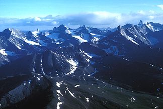
Die Arrigetch Peaks
Höchster Gipfel Thibodeaux Mountain (2.298 m) Lage Alaska (USA) Teil der Brookskette 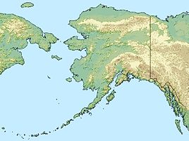

Koordinaten 68° 10′ N, 149° 30′ W68.166667-149.52298Koordinaten: 68° 10′ N, 149° 30′ W Fläche 50.000 km² Die Endicott Mountains sind ein Gebirgszug der Brookskette im Interior von Alaska. Sie erstrecken sich über eine Fläche von etwa 50.000 km² von Noatak River, Kaluluktok Creek und Walker Lake im Westen bis Atigun River, Dietrich River und der Middle Fork des Koyukuk River im Osten.
Im Südwesten der Endicott Mountains liegen die Arrigetch Peaks, eine Gruppe von Granitgipfeln im Quellgebiet des Kobuk River mit einer Höhe von bis zu 2192 m, die 1968 als National Natural Landmark ausgewiesen wurden. [1]
 Aufnahme der Endicott Mountains aus dem Jahr 1901
Die höchste Erhebung ist der Thibodeaux Mountain mit 2298 m. Die Endicott Mountains beinhalten einige untergeordnete Gebirgszüge wie die Akoliakruich Hills, Alatna Hills, Angayucham Mountains, Becks Hills, Helpmejack Hills, Jack White Range, Ninemile Hills und die Schwatka Mountains.
Neben dem Kobuk haben mit dem Alatna und dem Koyukuk River zwei weitere Wild and Scenic Rivers ihre Quellgebiete in den Endicott Mountains.
Der Gebirgszugs liegt im Gates-of-the-Arctic-Nationalpark, im Osten grenzt das Arctic National Wildlife Refuge an. Der Dalton Highway von Fairbanks nach Prudhoe Bay, die einzige Straße, die die Brookskette überquert, verläuft zwischen Endicott Mountains und Philip Smith Mountains.
Benannt wurde der Gebirgszug 1885 von Henry Tureman Allen nach William Crowninshield Endicott, Kriegsminister unter Präsident Grover Cleveland.
Einzelnachweise
- ↑ National Natural Landmark: Arrigetch Peaks auf nps.gov
Weblinks
Kategorien:- Brookskette
- Gebirge in Nordamerika
- Gebirge in Alaska


Wikimedia Foundation.