Ailinglaplap

Ailinglaplap
Ailinglaplap
NASA-Bild von Ailinglaplap
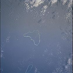
Gewässer Pazifischer Ozean
Archipel
Anzahl der Inseln 56
Hauptinsel Bikar
Landfläche 14,69 km²dep1
Lagunenfläche 750,29 km²dep1
Einwohner 1959 (1999)
Geographische Lage 7° 31′ N, 168° 44′ O7.5094444444444168.736111111117Koordinaten: 7° 31′ N, 168° 44′ O
Ailinglaplap (Marshallinseln)
DEC
Ailinglaplap
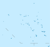
Karte der Marshallinseln, mittig Ailinglaplap

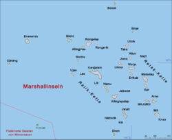
Ailinglaplap ist ein Atoll der Ralik-Kette der Marshallinseln. Das Atoll hat eine dreieckige Form von 43 km Länge und maximal 30 km Breite. Australien liegt etwa 3400 km von Ailinglaplap entfernt. Die bedeutendsten Inseln des Atolls sind Airuk, Beran, Bikar, Buoj, Enewe, Ennak, Jabwan, Jeh, Kattiej, Mejajok, Mejil, Tobomaro und Woja.

Geschichte

In der Sprache der polynesischen Einwohner der Marshallinseln bedeutet der Name Ailinglaplap soviel wie Große Insel.

Historische Karte des Atolls

Für die Europäer wurde das Eiland am 15. Dezember 1792 von dem englischen Kaufmann Henry Bond entdeckt.

Ende des 19. Jahrhunderts wurde die Insel, ähnlich anderen Atollen, für die Produktion von Kopra genutzt. Vor allem deutsche Kaufleute pflanzten dazu Kokospalmen an. Die Vegetation der Insel besteht heute hauptsächlich aus Kokospalmen.

Im Unterhaus des Parlaments der Marshallinseln haben zwei Vertreter des Atolls ein ständiges Mandat.

Das Atoll hat ein Flugfeld, IATA-Code: AIP.

Weblinks


Wikimedia Foundation.

Игры ⚽ Нужно сделать НИР?

Schlagen Sie auch in anderen Wörterbüchern nach:

  • Ailinglaplap — Carte allemande de l atoll (1981). Géographie Pays …   Wikipédia en Français

  • Ailinglaplap — es un atolón compuesto por 56 islas en el océano Pacífico. Es un distrito legislativo de las Islas Marshall, con un área total de 15 km² y una laguna interior de 750 km². Ailinglaplap significa isla muy grande . Los tres centros poblacionales más …   Wikipedia Español

  • Ailinglaplap Atoll — Ailinglaplap is an atoll and municipality of 56 islands in the Pacific Ocean. It is a legislative district of the Marshall Islands, located in the Ralik Chain. It is located 152 km northwest of Jaluit Atoll. Its total land area is only 5.67 sq mi …   Wikipedia

  • Ailinglaplap Atoll — Admin ASC 1 Code Orig. name Ailinglaplap Atoll Country and Admin Code MH.010 MH …   World countries Adminstrative division ASC I-II

  • Atoll d'Ailinglaplap — Ailinglaplap Ailinglaplap Carte allemande de l atoll (1981). Géographie Pays …   Wikipédia en Français

  • Ailinglapalap — Vorlage:Infobox Insel/Wartung/Höhe fehlt Ailinglaplap NASA Bild von Ailinglaplap Gewässer Pazifischer Ozean Archipel …   Deutsch Wikipedia

  • Marshall Islands — Republic of the Marshall Islands Aolepān Aorōkin M̧ajeļ[1][2] …   Wikipedia

  • Kessai Note — Infobox President name = Kessai Hesa Note order = President of the Marshall Islands vicepresident = term start = 10 January 2000 term end = 14 January 2008 predecessor = Imata Kabua successor = Litokwa Tomeing birth date = birth date and… …   Wikipedia

  • Typhoon Paka — Infobox Hurricane Name = Typhoon Paka Type = typhoon Year = 1997 Basin = EPac Image location = Paka 15 dec 1997 0429Z.jpg Formed = November 28, 1997 Dissipated = December 23, 1997 1 min winds = 160 10 min winds = 100 Pressure = 901 Damages = 580… …   Wikipedia

  • Archipel Ralik — Îles Ralik Pour les articles homonymes, voir Ralik. Îles Ralik Géographie Pays …   Wikipédia en Français

Share the article and excerpts

Direct link
Do a right-click on the link above
and select “Copy Link”