- Akabira
-
Akabira-shi
赤平市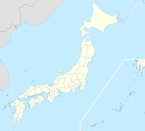

Geographische Lage in Japan Region: Hokkaidō Präfektur: Hokkaidō Koordinaten: 43° 12′ N, 141° 47′ O43.196027777778141.77575Koordinaten: 43° 11′ 46″ N, 141° 46′ 33″ O Basisdaten Fläche: 129,88 km² Einwohner: 12.408
(30. Juni 2011)Bevölkerungsdichte: 96 Einwohner je km² Gemeindeschlüssel: 01218-1 Symbole Baum: Ahorne Blume: Chrysanthemen Rathaus Adresse: Akabira City Hall
4-1 Izumi-chō
Akabira-shi
Hokkaidō 079-1192Webadresse: http://www.city.akabira.hokkaido.jp Lage Akabiras in der Präfektur Hokkaidō 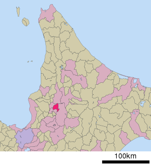
Akabira (jap. 赤平市, -shi) ist eine Stadt in der Unterpräfektur Sorachi auf der Insel Hokkaido (Japan).
Inhaltsverzeichnis
Geographie
Akabira liegt südwestlich von Asahikawa und nordöstlich von Sapporo.
Geschichte
Die Stadt besteht seit dem 1. Juli 1954.
Verkehr
- Zug:
- Straße:
- Nationalstraße 38
Städtepartnerschaften
Angrenzende Städte und Gemeinden
Weblinks
-
 Commons: Akabira – Sammlung von Bildern, Videos und Audiodateien
 Gemeinden und Landkreise in der Präfektur Hokkaidō
Abashiri | Akabira | Asahikawa | Ashibetsu | Bibai | Chitose | Date | Ebetsu | Eniwa | Fukagawa | Furano | Hakodate | Hokuto | Ishikari | Iwamizawa | Kitahiroshima | Kitami | Kushiro | Mikasa | Mombetsu | Muroran | Nayoro | Nemuro | Noboribetsu | Obihiro | Otaru | Rumoi | Sapporo (Verwaltungssitz) | Shibetsu | Sunagawa | Takikawa | Tomakomai | Utashinai | Wakkanai | Yūbari
Abashiri-gun: Ōzora | Bihoro | Tsubetsu | Abuta-gun: Toyoura | Tōyako | Niseko | Makkari | Rusutsu | Kimobetsu | Kyōgoku | Kutchan | Akan-gun: Tsurui | Akkeshi-gun: Akkeshi | Hamanaka | Ashoro-gun: Ashoro | Rikubetsu | Esashi-gun: Hamatombetsu | Nakatombetsu | Esashi | Furubira-gun: Furubira | Furuu-gun: Tomari | Kamoenai | Futami-gun: Yakumo | Hidaka-gun: Shinhidaka | Hiroo-gun: Taiki | Hiroo | Hiyama-gun: Esashi | Kaminokuni | Assabu | Horoizumi-gun: Erimo | Ishikari-gun: Tōbetsu | Shinshinotsu | Isoya-gun: Rankoshi | Iwanai-gun: Kyōwa | Iwanai | Kabato-gun: Tsukigata | Urausu | Shintotsukawa | Kameda-gun: Nanae | Kamiiso-gun: Shiriuchi | Kikonai | Kamikawa-gun (Ishikari): Takasu | Higashikagura | Tōma | Pippu | Aibetsu | Kamikawa | Higashikawa | Biei | Kamikawa-gun (Teshio): Wassamu | Kembuchi | Shimokawa | Kamikawa-gun (Tokachi): Shintoku | Shimizu | Kasai-gun: Memuro | Nakasatsunai | Sarabetsu | Katō-gun: Otofuke | Shihoro | Kamishihoro | Shikaoi | Kawakami-gun: Shibecha | Teshikaga | Kayabe-gun: Shikabe | Mori | Kudō-gun: Setana | Kushiro-gun: Kushiro | Mashike-gun: Mashike | Matsumae-gun: Matsumae | Fukushima | Menashi-gun: Rausu | Mombetsu-gun: Engaru | Yūbetsu | Takinoue | Okoppe | Nishiokoppe | Ōmu | Nakagawa-gun (Teshio): Bifuka | Otoineppu | Nakagawa | Nakagawa-gun (Tokachi): Makubetsu | Ikeda | Toyokoro | Honbetsu | Niikappu-gun: Niikappu | Nishi-gun: Otobe | Notsuke-gun: Betsukai | Okushiri-gun: Okushiri | Rebun-gun: Rebun | Rishiri-gun: Rishiri | Rishirifuji | Rumoi-gun: Obira | Samani-gun: Samani | Saru-gun: Biratori | Hidaka | Setana-gun: Imakane | Shakotan-gun: Shakotan | Shari-gun: Shari | Kiyosato | Koshimizu | Shibetsu-gun: Nakashibetsu | Shibetsu | Shimamaki-gun: Shimamaki | Shiranuka-gun: Shiranuka | Shiraoi-gun: Shiraoi | Sorachi-gun: Kamifurano | Kamisunagawa | Minamifurano | Naie | Nakafurano | Namporo | Sōya-gun: Sarufutsu | Suttsu-gun: Suttsu | Kuromatsunai | Teshio-gun: Embetsu | Teshio | Horonobe | Toyotomi | Tokachi-gun: Urahoro | Tokoro-gun: Kunneppu | Oketo | Saroma | Tomamae-gun: Tomamae | Haboro | Shosambetsu | Urakawa-gun: Urakawa | Uryū-gun: Moseushi | Chippubetsu | Uryū | Hokuryū | Numata | Horokanai | Usu-gun: Sōbetsu | Yamakoshi-gun: Oshamambe | Yoichi-gun: Niki | Yoichi | Akaigawa | Yūbari-gun: Yuni | Naganuma | Kuriyama | Yūfutsu-gun: Abira | Atsuma | Mukawa | Shimukappu
Wikimedia Foundation.
Schlagen Sie auch in anderen Wörterbüchern nach:
Akabira — 43°33′10″N 142°3′50″E / 43.55278, 142.06389 … Wikipédia en Français
Akabira — Original name in latin Akabira Name in other language Akabira, Kami akabira State code JP Continent/City Asia/Tokyo longitude 43.55139 latitude 142.05306 altitude 57 Population 14214 Date 2012 01 19 … Cities with a population over 1000 database
Akabira, Hokkaidō — nihongo|Akabira|赤平市|Akabira shi is a city located in central Sorachi Subprefecture, Hokkaidō, Japan. The name is Ainu for Mountain Ridge.As of 2008, the city has an estimated population of 13,716 and the density of 115.59 persons per km². The… … Wikipedia
Akabira Station — PAGENAME is a railway station of JR Hokkaido Nemuro Main Line located in Akabira, Hokkaidō, Japan which opened at Nov. 10, 1913.External links … Wikipedia
Akabira-shi — Admin ASC 2 Code Orig. name Akabira shi Country and Admin Code JP.12.2130704 JP … World countries Adminstrative division ASC I-II
Hiragishi Station (Akabira, Hokkaidō) — nihongo|Hiragishi Station|平岸駅|Hiragishi eki is a railway station on the Nemuro Main Line of JR Hokkaido located in Akabira, Hokkaidō, Japan. Structure Service Nearby stations … Wikipedia
Hokkaidō Prefectural Board of Education — Hokkaido Prefectural Board of Education (北海道教育委員会) is a governmental agency that oversees public schools in Hokkaidō in Japan.The board directly oversees high schools in Hokkaidō.High schools [http://www.ipec.hokkaido c.ed.jp/links/gakkou.html]… … Wikipedia
Utashinai, Hokkaidō — Infobox City Japan Name= Utashinai JapaneseName= 歌志内市 Map Region= Hokkaidō Prefecture= Hokkaidō (Sorachi) District= Area km2= 55.99 PopDate= June 2008 Population= 4,845 Density km2= 86.5 Coords= LatitudeDegrees= 43 LatitudeMinutes= 31… … Wikipedia
List of official city birds — The following is a list of official city birds, organized by country.Canada*Victoria, British Columbia Great Blue Heron, Ardea herodias (suggested, as yet unofficial) [http://www.heroncam.com/newsarchive/2004 03 26.html] China*Guangzhou,… … Wikipedia
Nemuro Main Line — Nemuro line map KiHa 283 series … Wikipedia
Akabira


18+
© Academic, 2000-2024
- Kontaktieren Sie uns: Unterstützung, Werbung
Wörterbücher Export, schritte mit PHP, Joomla, Drupal, WordPress, MODx.