Flinders Ranges National Park
- Flinders Ranges National Park
-
| Flinders Ranges National Park |
|
Wilpena Pound |
|
|
| Lage: |
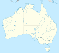
South Australia |
| Besonderheit: |
Berglandschaft, Felszeichnungen |
| Nächste Stadt: |
Hawker |
| Fläche: |
950 km² |
| Gründung: |
1945 |

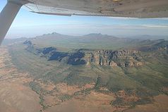
Wilpena Pound
Der Flinderskette-Nationalpark (engl. Flinders Ranges National Park) ist ein 950 km² großes, im Gebirgszug der Flinderskette im australischen Bundesstaat South Australia (Südaustralien) gelegenes Naturschutzgebiet.
Die Landschaft des Nationalparks ist durch schroffe Mittelgebirgskämme, tiefe Schluchten und sonnenverbrannte Talflächen gekennzeichnet. Für die Flora des Parks ist der Eukalyptus-ähnliche Baum River Red Gum (Eucalyptus camaldulensis) typisch.
Weblinks
-31.422222222222138.7057Koordinaten: 31° 25′ 20″ S, 138° 42′ 18″ O
Wikimedia Foundation.
Schlagen Sie auch in anderen Wörterbüchern nach:
Flinders Ranges National Park — Infobox protected area of Australia | name = Flinders Ranges National Park iucn category = II caption = locator x = 176 locator y = 152 nearest town or city = Hawker coordinates = coord|31|25|20|S|138|42|18|E| area = 912 km² established = 1945… … Wikipedia
Flinders Ranges National Park — noun a national park located in the Flinders Ranges, SA. 95 000 ha …
Vulkathunha-Gammon Ranges National Park — The Gammon Ranges are part of the northern Flinders Ranges, immediately southwest of and adjacent to Arkaroola Sanctuary. They encompass some of the most rugged and spectacular country in South Australia.GeographyThe central ranges are of a… … Wikipedia
Flinders-Ranges-Nationalpark — Flinders Ranges National Park Wilpena Pound … Deutsch Wikipedia
Flinders Ranges — [ flɪndəz reɪndʒəz], nach M. Flinders benannte Bergkette im Bundesstaat South Australia, Australien, nordöstlich von Port Augusta, rd. 800 km lang, bis 1 165 m über dem Meeresspiegel (Saint Mary Peak); die Flinders Ranges sind reich an Kohle… … Universal-Lexikon
Vulkathunha-Gammon Ranges National Park — /vʊlkəˌtanə ˈgæmən/ (say voolkuh.tahnuh gamuhn) noun a national park in central eastern SA, west of Lake Frome, incorporating the northern part of the Flinders Ranges. 128 230 ha. Formerly (until 2003), Gammon Ranges National Park …
Flinders Ranges — The Flinders Ranges is South Australia s largest mountain range which starts approximately 200 km north west of Adelaide. The discontinuous ranges stretch for over 430 km from Port Pirie to Lake Callabonna. Its most characteristic landmark is… … Wikipedia
Flinders Ranges — p1f1 Flinderskette Höchster Gipfel St. Mary’s Peak (1.170 m) Lage South Australia Teil von Australien … Deutsch Wikipedia
Flinders Ranges — Mountain region north of Adelaide, South Australia. Continuing the Mount Lofty Ranges from Gulf St. Vincent, it extends some 250 mi (400 km) to the northeast. The Flinders exceed 3,000 ft (900 m) at several points, reaching 3,825 ft (1,166 m) at… … Universalium
Flinders Ranges — /flɪndəz ˈreɪndʒəz/ (say flinduhz raynjuhz) plural noun mountain ranges in south eastern SA extending over 400 km from Port Pirie and Peterborough to the areas between Lake Torrens and Lake Frome. Highest peak, St Mary Peak, 1171 m. The Flinders… …