- Alamance County
-
Verwaltung US-Bundesstaat: North Carolina Verwaltungssitz: Graham Adresse des
Verwaltungssitzes:County Office Building
124 West Elm St
Graham, NC 27253-2802Gründung: 29. Januar 1849 Gebildet aus: Orange County Vorwahl: 001 336 Demographie Einwohner: 130.800 (2000) Bevölkerungsdichte: 117,4 Einwohner/km² Geographie Fläche gesamt: 1.126 km² Wasserfläche: 12 km² Karte 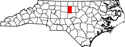
Website: www.alamance-nc.com Das Alamance County[2] ist ein County im Bundesstaat North Carolina der Vereinigten Staaten von Amerika. Der Verwaltungssitz (County Seat) ist Graham, das nach dem Gouverneur William Alexander Graham benannt wurde.
Inhaltsverzeichnis
Geografie
Das County liegt nördlich des geographischen Zentrums von North Carolina, ist im Norden etwa 40 km von Virginia entfernt und hat eine Fläche von 1126 Quadratkilometern, wovon 12 Quadratkilometer Wasserfläche sind. Es grenzt im Uhrzeigersinn an folgende Countys: Caswell County, Orange County, Chatham County, Randolph County und Guilford County.
Alamance County ist in 13 Townships aufgeteilt: 1 (Patterson), 2 (Coble), 3 (Boone Station), 4 (Morton), 5 (Faucette), 6 (Graham), 7 (Albright), 8 (Newlin), 9 (Thompson), 10 (Melville), 11 (Pleasant Grove), 12 (Burlington) und 13 (Haw River).
Geschichte
Alamance County wurde am 29. Januar 1849 aus Teilen des Orange County gebildet. Benannt wurde es nach dem Great Alamance Creek, einem 19 km langen Flüsschen, das in den Haw River mündet.
Demografische Daten
Historische Einwohnerzahlen Census Einwohner ± in % 1850 11.444 — 1860 11.852 4 % 1870 11.874 0,2 % 1880 14.613 20 % 1890 18.271 30 % 1900 25.665 40 % 1910 28.712 10 % 1920 32.718 10 % 1930 42.140 30 % 1940 57.427 40 % 1950 71.220 20 % 1960 85.674 20 % 1970 96.362 10 % 1980 99.319 3 % 1990 108.213 9 % 2000 130.800 20 % Vor 1900[3] Nach der Volkszählung im Jahr 2000 lebten im Alamance County 130.800 Menschen in 51.584 Haushalten und 35.541 Familien. Die Bevölkerungsdichte beträgt 117 Einwohner pro Quadratkilometer. Ethnisch betrachtet setzt sich die Bevölkerung zusammen aus 75,61 Prozent Weißen, 18,76 Prozent Afroamerikanern, 0,35 Prozent amerikanischen Ureinwohnern, 0,90 Prozent Asiaten, 0,02 Prozent Bewohnern aus dem pazifischen Inselraum und 3,19 Prozent aus anderen ethnischen Gruppen; 1,16 Prozent stammten von zwei oder mehr Ethnien ab. 6,75 Prozent der Bevölkerung waren spanischer oder lateinamerikanischer Abstammung.
Von den 51.584 Haushalten hatten 31,1 Prozent Kinder unter 18 Jahren, die bei ihnen lebten. 52,1 Prozent davon waren verheiratete, zusammenlebende Paare, 12,7 Prozent waren allein erziehende Mütter und 31,1 Prozent waren keine Familien. 26,0 Prozent waren Singlehaushalte und in 10,1 Prozent lebten Menschen mit 65 Jahren oder älter. Die Durchschnittshaushaltsgröße betrug 2,46 und die durchschnittliche Familiengröße war 2,95 Personen.
23,8 Prozent der Bevölkerung waren unter 18 Jahre alt. 9,9 Prozent zwischen 18 und 24 Jahre, 29,9 Prozent zwischen 25 und 44 Jahre, 22,3 Prozent zwischen 45 und 64, und 14,1 Prozent waren 65 Jahre alt oder Älter. Das Durchschnittsalter betrug 36 Jahre. Auf alle weibliche Personen kamen 92,5 männliche Personen. Auf alle Frauen im Alter von 18 Jahren oder darüber kamen 89,0 Männer.
Das jährliche Durchschnittseinkommen eines Haushalts betrug 39.168 $ und das jährliche Durchschnittseinkommen einer Familie betrug 46.479 $. Männer hatten ein durchschnittliches Einkommen von 31.906 $ gegenüber den Frauen mit 23.367 $. Das Prokopfeinkommen betrug 19.391 $. 11,1 Prozent der Bevölkerung und 7,6 Prozent der Familien lebten unterhalb der Armutsgrenze. 13,3 Prozent von ihnen sind Kinder und Jugendliche unter 18 Jahre und 12,9 Prozent sind 65 Jahre oder älter. [6]
Städte und Gemeinden
- Alamance
- Altamahaw
- Burlington
- Elon
- Glen Raven
- Graham
- Green Level
- Haw River
- Kimesville
- Mebane
- Ossipee
- Saxapahaw
- Snow Camp
- Swepsonville
Siehe auch
Einzelnachweise
- ↑ Auszug aus dem National Register of Historic Places. Abgerufen am 13. März 2011
- ↑ GNIS-ID: 1008531. Abgerufen am 22. Februar 2011 (englisch).
- ↑ U.S. Census Bureau - Census of Population and Housing. Abgerufen am 15. März 2011
- ↑ Auszug aus Census.gov. Abgerufen am 20. Februar 2011
- ↑ Auszug aus factfinder.census.gov Abgerufen am 20. Februar 2011
- ↑ Alamance County, North Carolina, Datenblatt mit den Ergebnissen der Volkszählung im Jahre 2000 bei factfinder.census.gov.
Weblinks
 Commons: Alamance County – Sammlung von Bildern, Videos und Audiodateien
Liste der Countys in North Carolina
Alamance | Alexander | Alleghany | Anson | Ashe | Avery | Beaufort | Bertie | Bladen | Brunswick | Buncombe | Burke | Cabarrus | Caldwell | Camden | Carteret | Caswell | Catawba | Chatham | Cherokee | Chowan | Clay | Cleveland | Columbus | Craven | Cumberland | Currituck | Dare | Davidson | Davie | Duplin | Durham | Edgecombe | Forsyth | Franklin | Gaston | Gates | Graham | Granville | Greene | Guilford | Halifax | Harnett | Haywood | Henderson | Hertford | Hoke | Hyde | Iredell | Jackson | Johnston | Jones | Lee | Lenoir | Lincoln | Macon | Madison | Martin | McDowell | Mecklenburg | Mitchell | Montgomery | Moore | Nash | New Hanover | Northampton | Onslow | Orange | Pamlico | Pasquotank | Pender | Perquimans | Person | Pitt | Polk | Randolph | Richmond | Robeson | Rockingham | Rowan | Rutherford | Sampson | Scotland | Stanly | Stokes | Surry | Swain | Transylvania | Tyrrell | Union | Vance | Wake | Warren | Washington | Watauga | Wayne | Wilkes | Wilson | Yadkin | Yancey
Wikimedia Foundation.
Schlagen Sie auch in anderen Wörterbüchern nach:
Alamance County — Admin ASC 2 Code Orig. name Alamance County Country and Admin Code US.NC.001 US … World countries Adminstrative division ASC I-II
Alamance County, North Carolina — Infobox U.S. County county = Alamance County state = North Carolina map size = 250 founded = 1849 seat = Graham | area total sq mi =435 area land sq mi =430 area water sq mi =5 area percentage = 1.10% census yr = 2007 pop = 145360 density km2… … Wikipedia
National Register of Historic Places listings in Alamance County, North Carolina — Map of all coordinates from Google Map of all coordinates from Bing … Wikipedia
Mount Hermon, Alamance County, North Carolina — Mount Hermon Unincorporated community … Wikipedia
Dogwood Acres, Alamance County, North Carolina — Dogwood Acres Unincorporated community … Wikipedia
Carolina, Alamance County, North Carolina — Carolina is located on the Haw River in Alamance County, North Carolina. It is located 4/5 mile east southeast of Glencoe. It lies at an elevation of 591 feet (180 m).References*gnis|1019534 … Wikipedia
Alamance Community College — is a community college located in Graham, NC, serving the area of Alamance County, NC. It was established in 1958 as part of a statewide system known as industrial education centers.HistoryThe initiation of a statewide system of industrial… … Wikipedia
Alamance-Burlington School System — The Alamance Burlington School System is a school district covering Alamance County and the city of Burlington. It was created in 1996 by merging the respective systems of the county and city. In 2006 it had some 21,927 students (NC s 15th… … Wikipedia
Alamance, North Carolina — See Alamance (band), for the American Rock Pop band, Alamance.Infobox Settlement official name = Alamance, North Carolina settlement type = Village nickname = motto = imagesize = image caption = image mapsize = 250x200px map caption = Location of … Wikipedia
Alamance Battleground — Infobox nrhp | name =Alamance Battleground State Historic Site nrhp type = caption = nearest city= Alamance, North Carolina area = built =1771 architect= architecture= added = February 26, 1970 governing body = State refnum=70000435 cite… … Wikipedia
Alamance County


18+
© Academic, 2000-2024
- Kontaktieren Sie uns: Unterstützung, Werbung
Wörterbücher Export, schritte mit PHP, Joomla, Drupal, WordPress, MODx.