- Ghaghara
-
Ghaghara / Karnali 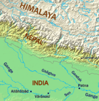
Lage des Ghaghara
Daten Lage Asien, Tibet, Nepal, Indien Flusssystem Ganges Abfluss über Ganges → Indischer Ozean Quelle südlich des Manasarovar, Tibet Quellhöhe 3.962 m Mündung bei Doriganj westlich Chhapra in den Ganges 25.74052909277384.67437744140635Koordinaten: 25° 44′ 26″ N, 84° 40′ 28″ O
25° 44′ 26″ N, 84° 40′ 28″ O25.74052909277384.67437744140635Mündungshöhe 35 m Höhenunterschied 3.927 m Länge 1.080 km Einzugsgebiet 127.950 km² Abflussmenge[1] MQ: 2.980 m³/s Rechte Nebenflüsse Seti, Sarda Linke Nebenflüsse Bheri, Rapti Großstädte Faizabad Die Ghaghara (Sanskrit: „Murmeln des Wassers“[1], Hindi: घाघरा Ghāghrā [ˈɡʱɑːɡrɑː]; auch Ghaghra, früher anglisiert Gogra) oder Karnali (Nepali: कर्णाली Karṇālī [kʌrˈnɑːliː]) ist ein linker Nebenfluss des Ganges. Sie entspringt im tibetischen Hochland am Gletscher des Gurla Mandhata, der im Süden des Sees Manasarovar liegt, durchquert den Himalaya und Nepal und mündet schließlich in den Ganges.
Die Ghaghara ist der längste Fluss in Nepal und, knapp vor der Yamuna, der größte Nebenfluss des Ganges. Am Oberlauf in Nepal trägt der Fluss den Namen Karnali, in Indien wird er Ghaghara genannt.
Einzelnachweise
Kategorien:- Flusssystem Ganges
- Fluss in Asien
- Fluss in Nepal
- Fluss in Indien
- Geographie (Uttar Pradesh)

Wikimedia Foundation.