- Greenwood County (South Carolina)
-
Verwaltung US-Bundesstaat: South Carolina Verwaltungssitz: Greenwood Adresse des
Verwaltungssitzes:County Courthouse
528 Monument Street
Greenwood, SC 29646-2643Gründung: 1897 Vorwahl: 001 864 Demographie Einwohner: 67.979 (2005) Bevölkerungsdichte: 57,6 Einwohner/km² Geographie Fläche gesamt: 1.199 km² Wasserfläche: 19 km² Karte 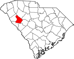
Website: www.co.greenwood.sc.us Greenwood County[1] ist ein County im Bundesstaat South Carolina der Vereinigten Staaten von Amerika. Der Verwaltungssitz (County Seat) ist Greenwood.
Inhaltsverzeichnis
Geografie
Das County liegt im Nordwesten von South Carolina, ist im Südwesten etwa 30 km von Georgia entfernt und hat eine Fläche von 1199 Quadratkilometern, wovon 19 Quadratkilometer Wasserfläche sind. Es grenzt im Uhrzeigersinn an folgende Countys: Laurens County, Newberry County, Edgefield County, Saluda County, McCormick County und Abbeville County.
Geschichte
Greenwood County wurde 1897 gebildet. Benannt wurde es nach der Greenwood-Plantage von Richter John McGehee.
Demografische Daten
Historische Einwohnerzahlen Census Einwohner ± in % 1900 28.343 — 1910 34.225 20 % 1920 35.791 5 % 1930 36.078 0,8 % 1940 40.083 10 % 1950 41.628 4 % 1960 44.346 7 % 1970 49.686 10 % 1980 57.847 20 % 1990 59.567 3 % 2000 66.271 10 % 1900–1990[2] 2000[3]
Nach der Volkszählung im Jahr 2000 lebten im Greenwood County 66.271 Menschen in 25.729 Haushalten und 17.753 Familien. Die Bevölkerungsdichte betrug 56 Einwohner pro Quadratkilometer. Ethnisch betrachtet setzte sich die Bevölkerung zusammen aus 65,57 Prozent Weißen, 31,74 Prozent Afroamerikanern, 0,18 Prozent amerikanischen Ureinwohnern, 0,71 Prozent Asiaten, 0,04 Prozent Bewohnern aus dem pazifischen Inselraum und 1,03 Prozent aus anderen ethnischen Gruppen; 0,74 Prozent stammten von zwei oder mehr Ethnien ab. 2,87 Prozent der Bevölkerung waren spanischer oder lateinamerikanischer Abstammung.
Von den 25.729 Haushalten hatten 31,7 Prozent Kinder unter 18 Jahre, die bei ihnen lebten. 48,7 Prozent waren verheiratete, zusammenlebende Paare, 16,1 Prozent waren allein erziehende Mütter, 31,0 Prozent waren keine Familien, 26,3 Prozent waren Singlehaushalte und in 10,6 Prozent lebten Menschen mit 65 Jahren oder darüber. Die Durchschnittshaushaltsgröße betrug 2,49 und die durchschnittliche Familiengröße betrug 3,00 Personen.
25,5 Prozent der Bevölkerung war unter 18 Jahre alt. 10,4 Prozent zwischen 18 und 24, 28,2 Prozent zwischen 25 und 44, 22,2 Prozent zwischen 45 und 64 und 13,7 Prozent waren 65 Jahre alt oder älter. Das Durchschnittsalter betrug 35 Jahre. Auf 100 weibliche Personen kamen 88,4 männliche Personen und auf 100 Frauen im Alter von 18 Jahren und darüber kamen 84,6 Männer.
Das jährliche Durchschnittseinkommen eines Haushalts betrug 34.702 USD, das Durchschnittseinkommen einer Familie betrug 42.022 USD. Männer hatten ein Durchschnittseinkommen von 30.759 USD, Frauen 23.820 USD. Das Prokopfeinkommen betrug 17.446 USD. 9,9 Prozent der Familien und 14,2 Prozent der Bevölkerung lebten unterhalb der Armutsgrenze. [4]
Siehe auch
Einzelnachweise
- ↑ Greenwood County im Geographic Names Information System des United States Geological Survey. Abgerufen am 22. Februar 2011
- ↑ Auszug aus Census.gov. Abgerufen am 28. Februar 2011
- ↑ Auszug aus factfinder.census.gov Abgerufen am 28. Februar 2011
- ↑ Greenwood County, South Carolina, Datenblatt mit den Ergebnissen der Volkszählung im Jahre 2000 bei factfinder.census.gov.

Liste der Countys in South Carolina
Abbeville | Aiken | Allendale | Anderson | Bamberg | Barnwell | Beaufort | Berkeley | Calhoun | Charleston | Cherokee | Chester | Chesterfield | Clarendon | Colleton | Darlington | Dillon | Dorchester | Edgefield | Fairfield | Florence | Georgetown | Greenville | Greenwood | Hampton | Horry | Jasper | Kershaw | Lancaster | Laurens | Lee | Lexington | Marion | Marlboro | McCormick | Newberry | Oconee | Orangeburg | Pickens | Richland | Saluda | Spartanburg | Sumter | Union | Williamsburg | York
Wikimedia Foundation.
Schlagen Sie auch in anderen Wörterbüchern nach:
Greenwood County, South Carolina — Infobox U.S. County county = Greenwood County state = South Carolina map size = 200 founded = 1897 seat = Greenwood | area total sq mi =463 area land sq mi =456 area water sq mi =7 area percentage = 1.60% census yr = 2000 pop = 66271 density km2 … Wikipedia
National Register of Historic Places listings in Greenwood County, South Carolina — Location of Greenwood County in South Carolina This is a list of the National Register of Historic Places listings in Greenwood County, South Carolina. This is intended to be a complete list of the properties and districts on the National… … Wikipedia
McCormick County, South Carolina — Location in the state of South Carolina … Wikipedia
Newberry County, South Carolina — Location in the state of South Carolina … Wikipedia
Abbeville County, South Carolina — Infobox U.S. County county = Abbeville County state = South Carolina map size = 200 founded = 1785 seat = Abbeville | area total sq mi =511 area land sq mi =508 area water sq mi =3 area percentage = 0.59% census yr = 2000 pop = 26167 density km2 … Wikipedia
Laurens County, South Carolina — Infobox U.S. County county = Laurens County state = South Carolina map size = 200 founded = 1785 seat = Laurens | area total sq mi =724 area land sq mi =715 area water sq mi =9 area percentage = 1.23% census yr = 2000 pop = 69567 density km2 =38… … Wikipedia
Edgefield County, South Carolina — Infobox U.S. County county = Edgefield County state = South Carolina map size = 200 founded = 1785 seat = Edgefield | area total sq mi =507 area land sq mi =502 area water sq mi =5 area percentage = 0.92% census yr = 2000 pop = 24595 density km2 … Wikipedia
Saluda County, South Carolina — Infobox U.S. County county = Saluda County state = South Carolina map size = 200 founded = 1896 seat = Saluda | area total sq mi =462 area land sq mi =452 area water sq mi =9 area percentage = 2.01% census yr = 2000 pop = 19181 density km2 =16… … Wikipedia
Charleston County, South Carolina — Seal … Wikipedia
Horry County, South Carolina — Old Horry County Courthouse, Conway, South Carolina … Wikipedia
Greenwood County (South Carolina)

18+
© Academic, 2000-2024
- Kontaktieren Sie uns: Unterstützung, Werbung
Wörterbücher Export, schritte mit PHP, Joomla, Drupal, WordPress, MODx.