- Guyra Shire
-
Shire of Guyra 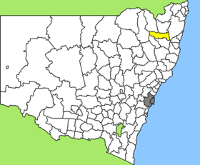
Lage des Guyra Shire in New South WalesGliederung Staat:  Australien
Bundesstaat:  New South Wales
Verwaltungssitz: Guyra Daten und Zahlen Fläche: 4.395 km² Einwohner: 4.229 (2006) [1] Bevölkerungsdichte: 1 Einwohner je km² Wards: 3 -30.2151.66666666667Koordinaten: 30° 12′ S, 151° 40′ OGuyra Shire ist ein lokales Verwaltungsgebiet (LGA) im australischen Bundesstaat New South Wales. Das Gebiet ist 4.395 km² groß und hat etwa 4.200 Einwohner.
Guyra liegt im Nordosten des Staates etwa 570 km nördlich der Metropole Sydney und 430 km südlich von Brisbane. Das Gebiet umfasst 57 Ortsteile und Ortschaften, darunter Backwater, Brockley, Guyra, Llangothlin, Oban, Tenderden, Tubbamurra, Wandsworth, Wards Mistake und Teile von Aberfoyle, Ben Lomond, Black Mountain, Bundarra, Ebor und Tingha. Der Sitz des Shire Councils befindet sich in Guyra im Zentrum der LGA, wo etwa 1.800 Einwohner leben.
Verwaltung
Der Guyra Shire Council hat sechs Mitglieder, die von den Bewohnern der drei Wards gewählt werden (je zwei aus A, B und C Ward). Diese drei Bezirke sind unabhängig von den Ortschaften festgelegt. Aus dem Kreis der Councillor rekrutiert sich auch der Mayor (Bürgermeister) des Councils.
Weblinks
- Offizielle Seite des Guyra Shire Council (englisch)
Einzelnachweise
- ↑ Australian Bureau of Statistics (25. Oktober 2007): Guyra (A) (Local Government Area) (Englisch). 2006 Census QuickStats. Abgerufen am 6. April 2010.
Kategorie:- Local Government Area in New South Wales

Wikimedia Foundation.