- Allegheny County
-
Verwaltung US-Bundesstaat: Pennsylvania Verwaltungssitz: Pittsburgh Adresse des
Verwaltungssitzes:Allegheny County Courthouse
436 Grant St
Pittsburgh, PA 15219-2400Gründung: 1788 Gebildet aus: Washington County
Westmoreland CountyVorwahl: +1 412 Demographie Einwohner: 1.223.348 (2010) Bevölkerungsdichte: 646,9 Einwohner/km² Geographie Fläche gesamt: 1.929 km² Wasserfläche: 38 km² Karte 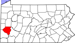
Website: www.county.allegheny.pa.us Das Allegheny County[2] ist ein County im US-amerikanischen Bundesstaat Pennsylvania. Bei der Volkszählung im Jahr 2010 hatte das County 1.223.348 Einwohner und eine Bevölkerungsdichte von 646,9 Einwohnern pro Quadratkilometer. Der Verwaltungssitz (County Seat) ist Pittsburgh.[3]
Das Allegheny County ist den Kern der Metropolregion um die Stadt Pittsburgh.
Inhaltsverzeichnis
Geografie
Das County liegt im Südwesten von Pennsylvania inmitten des Ballungsgebietes um die Stadt Pittsburgh am Zusammenfluss von Monongahela River und Allegheny River zum Ohio River. Es hat eine Fläche von 1.929 Quadratkilometern, wovon 38 Quadratkilometer Wasserfläche sind.An das Allegheny County grenzen folgende Countys:
Beaver County Butler County Armstrong County 
Westmoreland County Washington County Geschichte
Das County wurde am 24. September 1788 aus ehemaligen Teilen des Washington und des Westmoreland County gebildet. Benannt wurde es nach dem Alleghany River.
Demografische Daten
Historische Einwohnerzahlen Census Einwohner ± in % 1790 10.203 — 1800 15.087 50 % 1810 25.317 70 % 1820 34.921 40 % 1830 50.552 40 % 1840 81.235 60 % 1850 138.290 70 % 1860 178.831 30 % 1870 262.204 50 % 1880 355.869 40 % 1890 551.959 60 % 1900 775.058 40 % 1910 1.018.463 30 % 1920 1.185.808 20 % 1930 1.374.410 20 % 1940 1.411.539 3 % 1950 1.515.237 7 % 1960 1.628.587 7 % 1970 1.605.016 -1 % 1980 1.450.085 -10 % 1990 1.336.449 -8 % 2000 1.281.666 -4 % 2010 1.223.348 -5 % vor 1900[4]1900–1990[5] 2000[6] 2010[7]  Das Allegheny County Office Building in Pittsburgh
Nach der Volkszählung im Jahr 2010 lebten im Allegheny County 1.223.348 Menschen in 524.584 Haushalten. Die Bevölkerungsdichte betrug 646,9 Einwohner pro Quadratkilometer.
Ethnisch betrachtet setzte sich die Bevölkerung zusammen aus 81,5 Prozent Weißen, 13,2 Prozent Afroamerikanern, 0,1 Prozent amerikanischen Ureinwohnern, 2,8 Prozent Asiaten sowie aus anderen ethnischen Gruppen; 1,8 Prozent stammten von zwei oder mehr Ethnien ab. Unabhängig von der ethnischen Zugehörigkeit waren 1,6 Prozent der Bevölkerung spanischer oder lateinamerikanischer Abstammung.
In den 524.584 Haushalten lebten statistisch je 2,26 Personen.
19,8 Prozent der Bevölkerung waren unter 18 Jahre alt, 63,4 Prozent waren zwischen 18 und 64 und 16,8 Prozent waren 65 Jahre oder älter. 52,1 Prozent der Bevölkerung war weiblich.
Das jährliche Durchschnittseinkommen eines Haushalts lag bei 46.212 USD. Das Pro - Kopf - Einkommen betrug 28.825 USD. 13,0 Prozent der Einwohner lebten unterhalb der Armutsgrenze.[8]
Städte und Gemeinden
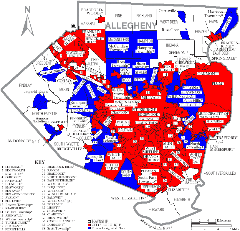
 Karte des Allegheny Countys
- Clairton
- Duquesne
- McKeesport
- Pittsburgh
- Aspinwall
- Avalon
- Baldwin
- Bell Acres
- Bellevue
- Ben Avon
- Ben Avon Heights
- Bethel Park
- Blawnox
- Brackenridge
- Braddock
- Braddock Hills
- Bradford Woods
- Brentwood
- Bridgeville
- Carnegie
- Castle Shannon
- Chalfant
- Cheswick
- Churchill
- Coraopolis
- Crafton
- Dormont
- Dravosburg
- East McKeesport
- East Pittsburgh
- Edgewood
- Edgeworth
- Elizabeth
- Emsworth
- Etna
- Forest Hills
- Fox Chapel
- Franklin Park
- Glassport
- Glen Osborne
- Glenfield
- Green Tree
- Haysville
- Heidelberg
- Homestead
- Ingram
- Jefferson Hills
- Leetsdale
- Liberty
- Lincoln
- McDonald1
- McKees Rocks
- Millvale
- Monroeville
- Mount Oliver
- Munhall
- North Braddock
- Oakdale
- Oakmont
- Pennsbury Village
- Pitcairn
- Pleasant Hills
- Plum
- Port Vue
- Rankin
- Rosslyn Farms
- Sewickley
- Sewickley Heights
- Sewickley Hills
- Sharpsburg
- Springdale
- Swissvale
- Tarentum
- Thornburg
- Trafford2
- Turtle Creek
- Verona
- Versailles
- Wall
- West Elizabeth
- West Homestead
- West Mifflin
- West View
- Whitaker
- White Oak
- Whitehall
- Wilkinsburg
- Wilmerding
Census-designated places (CDP)
- Allison Park
- Bairdford
- Bakerstown
- Clinton
- Curtisville
- Enlow
- Gibsonia
- Glenshaw
- Harwick
- Imperial
- Noblestown
- Rennerdale
- Russellton
- Sturgeon
- Acmetonia
- Blackridge
- Blanchard
- Broughton
- Bruceton
- Buena Vista
- Creighton
- Dorseyville
- Elfinwild
- Harmarville
- Hickory Heights
- Karns
- Keown Station
- Natrona
- Natrona Heights
- Warrendale
- Wexford
- Wildwood
1 - teilweise im Washington County
2 - teilweise im Westmoreland CountyTownships
- Aleppo Township
- Baldwin Township
- Collier Township
- Crescent Township
- East Deer Township
- Elizabeth Township
- Fawn Township
- Findlay Township
- Forward Township
- Frazer Township
- Hampton Township
- Harmar Township
- Indiana Township
- Kennedy Township
- Kilbuck Township
- Leet Township
- Marshall Township
- Moon Township
- Mount Lebanon Township
- Neville Township
- North Fayette Township
- North Versailles Township
- O'Hara Township
- Ohio Township
- Penn Hills Township
- Pine Township
- Reserve Township
- Richland Township
- Robinson Township
- Ross Township
- South Fayette Township
- South Park Township
- South Versailles Township
- Scott Township
- Shaler Township
- Springdale Township
- Stowe Township
- Upper St. Clair Township
- West Deer Township
- Wilkins Township
Einzelnachweise
- ↑ Auszug aus dem National Register of Historic Places - Nr. 73001586 Abgerufen am 28. Oktober 2011
- ↑ Allegheny County im Geographic Names Information System des United States Geological Survey Abgerufen am 22. Februar 2011
- ↑ National Association of Counties Abgerufen am 28. Oktober 2011
- ↑ University of Virginia Library - Historical Census Browser Abgerufen am 28. Oktober 2011
- ↑ Auszug aus Census.gov Abgerufen am 28. Februar 2011
- ↑ Auszug aus factfinder.census.gov Abgerufen am 28. Februar 2011
- ↑ United States Census 2010 Abgerufen am 28. Oktober 2011
- ↑ U.S. Census Buero, State & County QuickFacts - Allegheny County Abgerufen am 28. Oktober 2011
Weblinks
-
 Commons: Allegheny County, Pennsylvania – Sammlung von Bildern, Videos und Audiodateien
 - Offizielle Webseite
- U.S. Census Buero, State & County QuickFacts - Allegheny County
- Yahoo Bildersuche - Allegheny County
- www.city-data.com - Allegheny County

Liste der Countys in Pennsylvania
Adams | Allegheny | Armstrong | Beaver | Bedford | Berks | Blair | Bradford | Bucks | Butler | Cambria | Cameron | Carbon | Centre | Chester | Clarion | Clearfield | Clinton | Columbia | Crawford | Cumberland | Dauphin | Delaware | Elk | Erie | Fayette | Forest | Franklin | Fulton | Greene | Huntingdon | Indiana | Jefferson | Juniata | Lackawanna | Lancaster | Lawrence | Lebanon | Lehigh | Luzerne | Lycoming | McKean | Mercer | Mifflin | Monroe | Montgomery | Montour | Northampton | Northumberland | Perry | Philadelphia | Pike | Potter | Schuylkill | Snyder | Somerset | Sullivan | Susquehanna | Tioga | Union | Venango | Warren | Washington | Wayne | Westmoreland | Wyoming | York
Wikimedia Foundation.
Schlagen Sie auch in anderen Wörterbüchern nach:
Allegheny County — Comté d Allegheny Ne doit pas être confondu avec comté d Alleghany ou comté d Allegany. Comté d’Allegheny (Allegheny County) … Wikipédia en Français
Allegheny County — Admin ASC 2 Code Orig. name Allegheny County Country and Admin Code US.PA.003 US … World countries Adminstrative division ASC I-II
Allegheny County, Pennsylvania — Flag … Wikipedia
Allegheny County Airport Authority — is a Municipal Authority in Allegheny County that oversees and maintains the Allegheny County airport systems. These include management of Pittsburgh International Airport as well as Allegheny County Airport. The Authority is also a key lobbying… … Wikipedia
Allegheny County belt system — The Allegheny County belt system. (Click to expand.) Red Belt … Wikipedia
Allegheny County Library Association — Infobox Library library name = Allegheny County Library Association library caption = location = Pittsburgh, Pennsylvania coordinates = established = 1991 num branches = collection size = annual circulation = pop served = members = budget =… … Wikipedia
Allegheny County Courthouse — Infobox nrhp | name =Allegheny County Courthouse and Jail nrhp type =nhl caption =Allegheny County Courthouse, in 2004 location= Pittsburgh, Pennsylvania lat degrees = 40 | lat minutes = 26 | lat seconds = 18.56 | lat direction = N long degrees … Wikipedia
Allegheny County Police Department — The Allegheny County Police Department is a full service police department which patrols the Pittsburgh International Airport, the Allegheny County Airport, and county owned properties and parks, including North Park and South Park. The County… … Wikipedia
Allegheny County Airport — Infobox Airport name = Allegheny County Airport IATA = AGC ICAO = KAGC type = Public owner = Allegheny County Airport Authority location = Pittsburgh, Pennsylvania elevation f = 1,252 elevation m = 381.6 coordinates = coord|40|21|15.84|N|79|55|48 … Wikipedia
Port Authority of Allegheny County — Not to be confused with Port of Pittsburgh Commission. For other uses, see PAT (disambiguation). Port Authority of Allegheny County … Wikipedia
Allegheny County


18+
© Academic, 2000-2024
- Kontaktieren Sie uns: Unterstützung, Werbung
Wörterbücher Export, schritte mit PHP, Joomla, Drupal, WordPress, MODx.