- Harlem River Bridge
-
Harlem River Bridge "Harlem River Bridge at Third Avenue" (stereoskopisches Bild)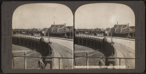
Nutzung Hochbahn und Fußgänger Querung von Harlem River Ort New York City Konstruktion Drehbrücke Schließung 1955 Die Harlem River Bridge war eine zweistöckige Eisenbahn- und Fußgängerdrehbrücke über den Harlem River in New York City. Sie befand sich etwa auf halber Höhe zwischen der Third Avenue Bridge und der Willis Avenue Bridge und war bis 1955 in Betrieb.
Auf der Brücke überquerte die New Yorker Hochbahnstrecke IRT Third Avenue Line den Harlem River. Diese lief am Bahnhof 129th Street am Südufer des Flusses mit der IRT Second Avenue Line zusammen, führte über die Brücke und weiter bis zur Station 149th Street, wo wiederum die IRT White Plains Road Line von ihr abzweigte. Aufgrund des erhöhten Verkehrsaufkommens auf diesem Abschnitt besaß die Brücke zwei Ebenen. Bummler-Züge (locals), die an jeder Station hielten, benutzten die untere Ebene, während Express-Züge, die nicht an jeder Station hielten, auf der oberen Ebene verkehrten.
Auf der Nordseite gab es auf der unteren Ebene von Süden her gesehen einen Abzweig zum Betriebshof 133rd Street Yard sowie eine Gleisverbindung zur New York, Westchester and Boston Railway. Auf beiden Seiten der unteren Ebene waren ferner Laufstege für Fußgänger angebracht, die direkt von den Ufern aus über Treppen erreichbar waren.
Die Brücke verlor ihre Hauptfunktion 1955, als die IRT Third Avenue Line von Süden her bis zur Station 149th Street zurückgezogen wurde. Am 22. Mai 1956 wurde die Brücke schließlich gesprengt.[1] Heute (2008) sind keine Überreste mehr vorhanden.
Quellen
Weblinks
- Harlem River Bridge auf nycsubway.org
- 1920, Manhattan and Bronx Els - 2nd, 3rd, 6th, 9th Aves., 1920 (Gleisplan) auf nycsubway.org
- Third Avenue El (ca. 1950s) auf archive.org
Einzelnachweise
- ↑ OLD HARLEM SPAN REMOVED IN BLAST; Last of 3d Ave. Rail Bridge Demolished With Half-Ton of New Explosive In: The New York Times. 23. Mai 1956, S. 33.
Kategorien:- Ehemalige Brücke in den Vereinigten Staaten
- Brücke in Bronx
- Brücke in Manhattan
- Eisenbahnbrücke in den Vereinigten Staaten
- New York City Subway
- Erbaut in den 1890er Jahren

Wikimedia Foundation.