- Hay Shire
-
Shire of Hay 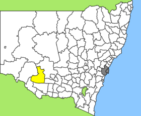
Lage des Hay Shire in New South WalesGliederung Staat:  Australien
Bundesstaat:  New South Wales
Verwaltungssitz: Hay Daten und Zahlen Fläche: 11.328 km² Einwohner: 3.383 (2006) [1] Bevölkerungsdichte: 0,3 Einwohner je km² -34.5144.85Koordinaten: 34° 30′ S, 144° 51′ OHay Shire ist ein lokales Verwaltungsgebiet (LGA) im australischen Bundesstaat New South Wales. Das Gebiet ist 1.896 km² groß und hat etwa 3.500 Einwohner.
Hay liegt im Südwesten des Staates an Murrumbidgee und Lachlan River etwa 720 km westlich der Metropole Sydney. Das Gebiet umfasst 24 Ortsteile und Ortschaften: Benarca, Benduck, Booligal, Burrabogie, Cobran, Eurolie, Eurugabah, Geramy, Hay, Hay Irrigation Area, Hay South, Hay West, Illilliwa, Maude, Nap Nap, Newmarket, Nulabor, One Tree, Pevensey, Ravensworth, Thelangerin, Toogimbie, Wyoming und ein Teil von Oxley. Der Sitz des Shire Councils befindet sich in Hay in der Südhälfte der LGA, wo etwa 2.600 Einwohner leben.
Verwaltung
Der Hay Shire Council hat acht Mitglieder, die von den Bewohnern der LGA gewählt werden. Hay ist nicht in Bezirke untergliedert. Aus dem Kreis der Councillor rekrutiert sich auch der Mayor (Bürgermeister) des Councils.
Weblinks
Einzelnachweise
- ↑ Australian Bureau of Statistics (25. Oktober 2007): Hay (A) (Local Government Area) (Englisch). 2006 Census QuickStats. Abgerufen am 6. April 2010.
Kategorie:- Local Government Area in New South Wales

Wikimedia Foundation.