- Amatole
-
Amatole
Amatole District MunicipalityAmatole (blau) in Ostkap (dunkelgrau)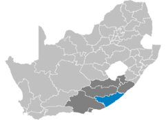
Staat: Südafrika Provinz: Ostkap Verwaltungssitz: East London Einwohner: 1.664.413
(2001)Fläche: 23.577 km² Webpräsenz: www.amathole.gov.za
(englisch)Der Distrikt (District Municipality) Amatole liegt in der Provinz Ostkap in Südafrika. Auf einer Fläche von 23.577 Quadratkilometer leben 1.664.413 Einwohner (Stand 2001). Die Hauptstadt ist East London. Benannt ist der Distrikt nach den Amatole-Bergen nordwestlich von King William’s Town.
Inhaltsverzeichnis
Gemeinden (Local Municipalities) mit ihren größten Städten
Als Beispiel für die Infrastruktur hier die Wasserversorgung der Haushalte (HWA = eigener Hauswasseranschluss; ÖWA = öffentlicher Wasseranschluss in der Nähe; KWA = kein Anschluss an ein Wasserleitungsnetz):[1]
Gemeinde Verwaltungssitz Fläche Einwohner H W A Ö W A K W A Amahlati Stutterheim 4269 km² 138.642 4 % 57 % 39 % Buffalo City East London 2528 km² 70.2271 16 % 76 % 8 % Great Kei Komga 1736 km² 44.450 4 % 68 % 28 % Mbhashe Idutywa 3050 km² 255.063 1 % 9 % 90 % Mnquma Butterworth 3299 km² 286.298 4 % 27 % 68 % Ngqushwa Peddie 2241 km² 84.224 1 % 60 % 40 % Nkonkobe Fort Beaufort 3724 km² 128.651 5 % 62 % 33 % Nxuba Adelaide 2732 km² 24.814 11 % 75 % 14 % Parks/Naturschutzgebiete
- Fort Fordyce Nature Reserve
- Gonubie Nature Reserve
- Nahoon Nature Reserve
- Umtiza Nature Reserve
Persönlichkeiten
- Steve Biko, geboren in King Williams Town, 1977 in der Haft ermordeter Gegner des Apartheid-Regimes
Weblinks
- Offizielle Website des Distriktes (englisch)
Einzelnachweise
Distrikte des OstkapsAlfred Nzo | Amatole | Cacadu | Chris Hani | O. R. Tambo | Nelson Mandela Bay | Ukhahlamba
-3327.9Koordinaten: 33° S, 28° O

Wikimedia Foundation.