- Jemo
-
Jemo Karte der Marshallinseln, Jemo Bildmitte rechts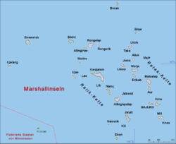
Gewässer Pazifischer Ozean Inselgruppe Ratak-Kette Geographische Lage 10° 4′ 45″ N, 169° 31′ 29″ O10.079166666667169.524722222221Koordinaten: 10° 4′ 45″ N, 169° 31′ 29″ O Länge 600 m Breite 400 m Fläche 0,22 km² Höchste Erhebung 1 m Einwohner (unbewohnt) Jemo ist eine unbewohnte Insel im Westen der Ratak-Kette der Marshallinseln.
Die kleine, ovale Insel mit einer Fläche von 0,22 km² liegt zwischen den Atollen Ailuk und Likiep.
Weblinks
 Atolle und Einzel-Inseln der Marshallinseln
Ratak-Kette: Ailuk | Arno-Atoll | Aur | Bikar | Bokak | Erikub | Knox-Atoll | Likiep | Majuro-Atoll | Maloelap | Mili | Toke | Utirik | Wotje
Keinem Atoll zugehörige Inseln: Jemo | Mejit
Ralik-Kette: Ailinginae | Ailinglapalap | Bikini-Atoll | Ebon-Atoll | Eniwetok | Jaluit | Kwajalein | Lae-Atoll | Namorik | Namu | Rongdrik | Rongelap-Atoll | Ujae | Ujelang | Wotho
Keinem Atoll zugehörige Inseln: Jabwot | Kili | Lib
Wikimedia Foundation.
Schlagen Sie auch in anderen Wörterbüchern nach:
Jemo — es una isla inhabitada de las Islas Marshall al noreste del atolón Likiep, en el Océano Pacífico. Tradicionalmente ha sido usada como despensa para los habitantes de likiep. Coordenadas: 10°04′39″N 169°31′30″E / … Wikipedia Español
Jemo — Jemo, eine der deutschen Marshallinseln (s. d.) … Meyers Großes Konversations-Lexikon
Jemo — For the Pacific island, see Jemo Island. : Jemo is also a soil type on tropical islands and atolls, characterized by raw humus overlying phosphatic hardpan. It originates from leaching of guano. Jemo is a Canadian acoustic rock band, consisting… … Wikipedia
Jemo — 10°07′N 169°33′E / 10.117, 169.55 Jemo est une île inhabitée des Marshall … Wikipédia en Français
Jemo Island — Jemo is an uninhabited island of the Marshall Islands north east of Likiep Atoll. It is traditionally held as a food reserve for the family of Joachim and Lijoan deBrum,pass down from Iroijlaplap Jortoka Lobareo and is owned by the current Likiep … Wikipedia
Jemo Island — Admin ASC 1 Code Orig. name Jemo Island Country and Admin Code MH.130 MH … World countries Adminstrative division ASC I-II
MH-L — Ratak Kette Karte der Marshallinseln, im Osten die Ratak Kette Gewässer Pazifischer Ozean Anzahl der Inseln 16 … Deutsch Wikipedia
Marshall Islands — Republic of the Marshall Islands Aolepān Aorōkin M̧ajeļ[1][2] … Wikipedia
Kandi, Murshidabad — Infobox Indian Jurisdiction native name = Kandi | type = city | latd = 23.95 | longd = 88.03 locator position = right | state name = West Bengal district = Murshidabad leader title = leader name = altitude = 20 population as of = 2001 population… … Wikipedia
Ailinglaplap — NASA Bild von Ailinglaplap Gewässer Pazifischer Ozean Archipel … Deutsch Wikipedia
Jemo

18+
© Academic, 2000-2024
- Kontaktieren Sie uns: Unterstützung, Werbung
Wörterbücher Export, schritte mit PHP, Joomla, Drupal, WordPress, MODx.