- Amphoe Ko Lanta
-
Ko Lanta
เกาะลันตาProvinz: Krabi Fläche: 339,843 km² Einwohner: 27.654 (2005) Bev.dichte: 81,4 E./km² PLZ: 81150 Geocode: 8103 Karte 
Ko Lanta (Thai: เกาะลันตา) ist ein Landkreis (Amphoe - Verwaltungs-Distrikt) im Süden der Provinz (Changwat) Krabi, Süd-Thailand. Die Provinz Krabi liegt etwa 810 km südlich von Bangkok. Ko Lanta ist auch der Name einer kleinen Insel in der Andamanensee.
Inhaltsverzeichnis
Geographie
Ko Lanta besteht aus zwei Inseln, die beide Teil des „Mu Ko Lanta Nationalparks“ (อุทยานแห่งชาติหมู่เกาะลันตา) sind. Sie heißen „Lanta Yai“ (เกาะลันตาใหญ่, Groß-Lanta, mit einer Ausdehnung von etwa 27 km Länge und 12-15 km Breite) und „Lanta Noi“ (เกาะลันตาน้อย, Klein-Lanta). Ko Lanta Yai im Norden wird von Ko Lanta Noi im Süden durch einen etwa einen Kilometer breiten, natürlichen Meerwasserfahrweg getrennt. Während Lanta Noi nahezu unbewohnt ist, ist Lanta Yai touristisch gut erschlossen.
Demographie
Ko Lanta Yai hat ungefähr 20.000 Einwohner, überwiegend moslemische Fischer. Etwa 4% der Bevölkerung sind chinesisch-stämmige Kaufleute, etwa 1% gehören der Volksgruppe der Moken an, die oft auch als „Seezigeuner“ bezeichnet werden. Neben dem Haupterwerbszweig, der Fischerei, betreiben die Einwohner noch Viehzucht, Reisanbau und bewirtschaften Kokos- und Kautschukplantagen.
 Ban Saladan auf Ko Lanta Yai
Geschichte
Der Landkreis Ko Lanta wurde im Dezember 1901 eingerichtet.
Der Ursprung des Namens ist unklar, möglicherweise kommt er von dem javanischen Wort Lantas, welches eine Art Fischgrill bezeichnet. Der Landkreis erhielt im Jahr 1917 offiziell den Namen „Ko Lanta“.
Verwaltung
Ko Lanta ist in fünf Gemeinden (Tambon) eingeteilt, welche wiederum in 37 Dorfgemeinschaften (Muban) unterteilt sind.
Ko Lanta Yai (เทศบาลตำบลเกาะลันตาใหญ่) ist auch der Name einer Kleinstadt (Thesaban Tambon) im Landkreis, sie besteht aus Teilen des Tambon Ko Lanta Yai.
Außerdem gibt es fünf „Tambon Administrative Organizations“ (TAO, องค์การบริหารส่วนตำบล – Verwaltungs-Organisationen) im Landkreis.
No. Name Thai Muban Einw. 1. Ko Lanta Yai เกาะลันตาใหญ่ 8 6.090 2. Ko Lanta Noi เกาะลันตาน้อย 8 4.858 3. Ko Klang เกาะกลาง 10 7.104 4. Khlong Yang คลองยาง 6 5.317 5. Sala Dan ศาลาด่าน 5 4.285 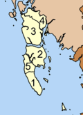
Weblinks
7.655599.04175Koordinaten: 7° 39′ N, 99° 3′ O
Mueang Krabi | Khao Phanom | Ko Lanta | Khlong Thom | Ao Luek | Plai Phraya | Lam Thap | Nuea Khlong
Wikimedia Foundation.
Schlagen Sie auch in anderen Wörterbüchern nach:
Amphoe Ko Lanta — Admin ASC 2 Code Orig. name Amphoe Ko Lanta Country and Admin Code TH.63.1152669 TH … World countries Adminstrative division ASC I-II
Amphoe Khlong Thom — Khlong Thom คลองท่อม Provinz: Krabi Fläche: 1042,53 km² Einwohner: 66.800 (2005) Bev.dichte: 61,1 E./km² PLZ: 81120 … Deutsch Wikipedia
Amphoe Nuea Khlong — Nuea Khlong เหนือคลอง Provinz: Krabi Fläche: 414,8 km² Einwohner: 54.789 (2005) Bev.dichte: 132,1 E./km² PLZ: 81130 … Deutsch Wikipedia
Amphoe Khao Phanom — Khao Phanom เขาพนม Provinz: Krabi Fläche: 788,5 km² Einwohner: 45.982 (2548) Bev.dichte: 58,3 E./km² PLZ: 81140 … Deutsch Wikipedia
Amphoe Lam Thap — Lam Thap ลำทับ Provinz: Krabi Fläche: 320,708 km² Einwohner: 20.069 (2005) Bev.dichte: 62,6 E./km² PLZ: 81120 … Deutsch Wikipedia
Amphoe Plai Phraya — Plai Phraya ปลายพระยา Provinz: Krabi Fläche: 433,4 km² Einwohner: 35.434 (2005) Bev.dichte: 81,8 E./km² PLZ: 81160 … Deutsch Wikipedia
Amphoe Ao Luek — Ao Luek อ่าวลึก Provinz: Krabi Fläche: 772,9 km² Einwohner: 48.474 (2005) Bev.dichte: 62,7 E./km² PLZ: 81110 … Deutsch Wikipedia
Amphoe Nuea Khlong — Infobox Amphoe thai=เหนือคลอง name=Nuea Khlong province=Krabi coordinates=coord|8|4|29|N|99|0|13|E|type:landmark region:TH capital=Nuea Khlong area=414.8 population=54,789 population as of=2548 density=132.1 postal code=81130 geocode=8108Nuea… … Wikipedia
Amphoe Khlong Thom — Infobox Amphoe name=Khlong Thom thai=คลองท่อม province=Krabi coordinates=coord|7|57|12|N|99|8|42|E|type:adm2nd region:TH area=1,042.531 population=66,800 population as of=2005 density=61.1 postal code=81120 geocode=8104Khlong Thom ( th. คลองท่อม) … Wikipedia
Koh Lanta — Datei:Karte Golf von Thailand.png Golf von Thailand Ko Lanta (Thai: เกาะลันตา) ist eine kleine Insel im Südwesten Thailands in der Andamanensee zugehörig zur Provinz Krabi. Ko Lanta ist auch Hauptsitz der Verwaltung des Landkreises (Amphoe) Ko… … Deutsch Wikipedia
Amphoe Ko Lanta


18+
© Academic, 2000-2024
- Kontaktieren Sie uns: Unterstützung, Werbung
Wörterbücher Export, schritte mit PHP, Joomla, Drupal, WordPress, MODx.