- Amphoe Mae Poen
-
Mae Poen
แม่เปินProvinz: Nakhon Sawan Fläche: 260,2 km² Einwohner: 19.730 (2005) Bev.dichte: 75,8 E./km² PLZ: 60150 Geocode: 6014 Karte 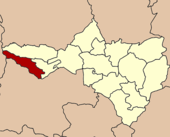
Amphoe Mae Poen (Thai: อำเภอ แม่เปิน) ist ein Landkreis (Amphoe - Verwaltungs-Distrikt) im westlichen Teil der Provinz Nakhon Sawan. Die Provinz Nakhon Sawan liegt im südlichen Teil der Nordregion von Thailand.
Inhaltsverzeichnis
Geographie
Benachbarte Distrikte (von Norden im Uhrzeigersinn): die Amphoe Mae Wong und Chum Ta Bong der Provinz Nakhon Sawan, die Amphoe Lan Sak und Ban Rai der Provinz Uthai Thani sowie Amphoe Umphang der Provinz Tak.
Geschichte
Der Landkreis Mae Poen wurde am 15. Juli 1996 zunächst als Unterbezirk (King Amphoe) eingerichtet, indem Tambon Mae Poen vom Amphoe Lat Yao abgetrennt wurde.[1]
Mit der Veröffentlichung in der Royal Gazette „Issue 124 chapter 46“ vom 24. August 2007 erhielt Mae Poen offiziell den vollen Amphoe-Status.[2]
Verwaltung
Amphoe Mae Poen hat nur eine einzige Gemeinde (Tambon), die wiederum in 24 Dorfgemeinschaften (Mubaan) eingeteilt ist.
Es gibt außerdem eine Verwaltungs-Organisation („Tambon Administrative Organization“ - TAO, Thai: องค์การบริหารส่วนตำบล).
Nr. Name Thai Dörfer Einw. 1. Mae Poen แม่เปิน 24 19.730 Einzelnachweise
- ↑ ประกาศกระทรวงมหาดไทย เรื่อง แบ่งเขตท้องที่อำเภอลาดยาว จังหวัดนครสวรรค์ ตั้งเป็นกิ่งอำเภอแม่เปิน Royal Gazette, Bd. 113, Ausg. 18 ง Spezial (พิเศษ) vom 15. Juni 1996, S. 15 (in Thai)
- ↑ พระราชกฤษฎีกาตั้งอำเภอฆ้องชัย...และอำเภอเหล่าเสือโก้ก พ.ศ. ๒๕๕๐ Royal Gazette, Vol.124, Issue 46 ก, S. 14-21 vom 24. August 2007 (in Thai)
Weblinks
 Amphoe von Nakhon Sawan
Mueang Nakhon Sawan | Krok Phra | Chum Saeng | Nong Bua | Banphot Phisai | Kao Liao | Takhli | Tha Tako | Phaisali | Phayuha Khiri | Lat Yao | Tak Fa | Mae Wong | Mae Poen | Chum Ta Bong
Wikimedia Foundation.
Schlagen Sie auch in anderen Wörterbüchern nach:
Amphoe Mae Poen — Admin ASC 2 Code Orig. name Amphoe Mae Poen Country and Admin Code TH.16.7510629 TH … World countries Adminstrative division ASC I-II
Amphoe Mae Poen — Infobox Amphoe thai=แม่เปิน name=Mae Poen province=Nakhon Sawan coordinates=coord|15|39|28|N|99|28|9|E|type:adm2nd region:TH capital=Mae Poen area=260.2 population=19,730 population as of=2005 density=75.8 postal code=60150 geocode=6014Mae Poen ( … Wikipedia
Mae Poen District — Mae Poen แม่เปิน Amphoe Amphoe location in Nakhon Sawan Province … Wikipedia
Amphoe Mae Wong — Mae Wong แม่วงก์ Provinz: Nakhon Sawan Fläche: 766,8 km² Einwohner: 52.705 (2005) Bev.dichte: 68,7 E./km² PLZ: 60150 … Deutsch Wikipedia
Amphoe Mae Wong — Infobox Amphoe thai=แม่วงก์ name=Mae Wong province=Nakhon Sawan coordinates=coord|15|46|52|N|99|31|9|E|type:adm2nd region:TH capital=Mae Wong area=766.8 population=52,705 population as of=2005 density=68.7 postal code=60150 geocode=6013Mae Wong ( … Wikipedia
Amphoe Chum Ta Bong — Chum Ta Bong ชุมตาบง Provinz: Nakhon Sawan Fläche: 379,04 km² Einwohner: 18.369 (2005) Bev.dichte: 48,5 E./km² PLZ: 60150 … Deutsch Wikipedia
Amphoe Umphang — Infobox Amphoe name=Umphang thai=อุ้มผาง province=Tak coordinates=coord|16|1|0|N|98|51|46|E|type:adm2nd region:TH area=4,325.4 population=25,757 population as of=2005 density=6.0 postal code=63170 geocode=6308Umphang ( th. อุ้มผาง) is the… … Wikipedia
Amphoe Ban Rai — Ban Rai บ้านไร่ Provinz: Uthai Thani Fläche: 3621,5 km² Einwohner: 66.167 (2005) Bev.dichte: 18,3 E./km² PLZ: 61140 … Deutsch Wikipedia
Amphoe Lan Sak — Lan Sak ลานสัก Provinz: Uthai Thani Fläche: 1080,4 km² Einwohner: 57.548 (2005) Bev.dichte: 53,3 E./km² PLZ: 61160 … Deutsch Wikipedia
Mae Wong District — Mae Wong แม่วงก์ Amphoe Amphoe location in Nakhon Sawan Province … Wikipedia
Amphoe Mae Poen


18+
© Academic, 2000-2024
- Kontaktieren Sie uns: Unterstützung, Werbung
Wörterbücher Export, schritte mit PHP, Joomla, Drupal, WordPress, MODx.