- Amphoe Si Sakhon
-
Si Sakhon
ศรีสาครProvinz: Narathiwat Fläche: 500,1 km² Einwohner: 31.576 (2005) Bev.dichte: 63,1 E./km² PLZ: 96210 Geocode: 9607 Karte 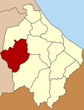
Amphoe Si Sakhon (Thai: อำเภอ ศรีสาคร) ist ein Landkreis (Amphoe - Verwaltungs-Distrikt) der Provinz Narathiwat. Die Provinz Narathiwat liegt im Südosten von Süd-Thailand an der Landesgrenze nach Malaysia.
Inhaltsverzeichnis
Geographie
Benachbarte Landkreise und Gebiete sind (von Norden im Uhrzeigersinn): die Amphoe Rueso, Ra-ngae und Chanae der Provinz Narathiwat sowie die Amphoe Than To und Bannang Sata der Provinz Yala.
Geschichte
Ursprünglich war das Gebiet des heutigen Landkreises Si Sakhon ein Tambon im Kreis Rueso mit dem Namen Sako. Da von 1963-1974 eine Division des thailändischen Militärs in Sako stationiert war, entwickelte sich die Infrastruktur des Tambon schnell. So richtete das Innenministerium am 23. September 1974 einen Kleinbezirk (King Amphoe) mit Namen Si Sakhon ein, der aus den beiden Tambon Sako und Tamayung bestand. [1] Am 25. März 1979 bekam Si Sakhon den vollen Amphoe-Status. [2][3]
Verwaltung
Amphoe Si Sakhon ist in sechs Unterbezirke (Tambon) eingeteilt, welche weiter in 39 Dorfgemeinschaften (Muban) unterteilt sind.
Si Sakhon (Thai: เทศบาลตำบลศรีสาคร) ist auch der Name einer Kleinstadt (Thesaban Tambon) im Landkreis, sie besteht aus Teilen der Tambon Si Sakhon und Sa Ko.
Außerdem gibt es sechs „Tambon Administrative Organizations“ (TAO, องค์การบริหารส่วนตำบล – Verwaltungs-Organisationen) im Landkreis.
Nr. Name Thai Muban Einwohner 1. Sako ซากอ 6 6.992 2. Tamayung ตะมะยูง 6 4.734 3. Si Sakhon ศรีสาคร 10 8.473 4. Choeng Khiri เชิงคีรี 4 4.750 5. Kalong กาหลง 4 2.730 6. Si Banphot ศรีบรรพต 9 3.897 Einzelnachweise
- ↑ ประกาศกระทรวงมหาดไทย เรื่อง แบ่งท้องที่อำเภอรือเสาะ จังหวัดนราธิวาส ตั้งเป็นกิ่งอำเภอศรีสาคร Royal Gazette, Band 91, Ausg. 158 ง vom 24. September 1974, S. 3589 (in Thai)
- ↑ พระราชกฤษฎีกาตั้งอำเภอหนองกุงศรี อำเภอไทรงาม อำเภอบ้านฝาง อำเภออุบลรัตน์ อำเภอเวียงชัย อำเภอดอยเต่า อำเภอนิคมคำสร้อย อำเภอนาหว้า อำเภอเสิงสาง อำเภอศรีสาคร อำเภอบึงสามพัน อำเภอนาดูน อำเภอค้อวัง อำเภอโพธิ์ชัย อำเภอเมืองสรวง อำเภอปลวกแดง อำเภอยางชุมน้อย อำเภอกาบเชิง อำเภอสุวรรณคูหา และอำเภอกุดข้าวปุ้น พ.ศ. ๒๕๒๒ Royal Gazette, Band 96, Ausg. 42 ก ฉบับพิเศษ (spezial) vom 25. März 1979, S. 19-24 (in Thai)
- ↑ narathiwat.go.th
Weblinks
6.2313888888889101.5Koordinaten: 6° 14′ N, 101° 30′ O Amphoe der Provinz Narathiwat
Amphoe: Mueang Narathiwat | Tak Bai | Bacho | Yi-ngo | Ra-ngae | Rueso | Si Sakhon | Waeng | Sukhirin | Su-ngai Kolok | Su-ngai Padi | Chanae | Cho-airong
Wikimedia Foundation.
Schlagen Sie auch in anderen Wörterbüchern nach:
Amphoe Si Sakhon — Admin ASC 2 Code Orig. name Amphoe Si Sakhon Country and Admin Code TH.31.7001159 TH … World countries Adminstrative division ASC I-II
Amphoe Si Sakhon — Infobox Amphoe thai=ศรีสาคร name=Si Sakhon province=Narathiwat coordinates=coord|6|13|53|N|101|30|0|E|type:adm2nd region:TH capital=Sako area=500.1 population=31,576 population as of=2005 density=63.1 postal code=96210 geocode=9607Si Sakhon ( th … Wikipedia
Amphoe Than To — Than To ธารโต Provinz: Yala Fläche: 648,0 km² Einwohner: 21.323 (2005) Bev.dichte: 32,9 E./km² PLZ: 95150 … Deutsch Wikipedia
Amphoe Ban Phaeo — Ban Phaeo บ้านแพ้ว Provinz: Samut Sakhon Fläche: 245,031 km² Einwohner: 90.961 (2005) Bev.dichte: 371 E./km² PLZ: 74120 … Deutsch Wikipedia
Amphoe Krathum Baen — Krathum Baen กระทุ่มแบน Provinz: Samut Sakhon Fläche: 135,276 km² Einwohner: 138.309 (2005) Bev.dichte: 1022 E./km² PLZ … Deutsch Wikipedia
Amphoe Mueang Samut Sakhon — Infobox Amphoe name=Mueang Samut Sakhon thai=เมืองสมุทรสาคร province=Samut Sakhon coordinates=coord|13|32|54|N|100|16|24|E|type:adm2nd region:TH area=492.04 population=222,747 population as of=2005 density=453 postal code=74000 geocode=7401Mueang … Wikipedia
Sakhon Nakhon (Provinz) — Sakon Nakhon สกลนคร Statistik Hauptstadt: Sakon Nakhon Tel.vorwahl: 042 … Deutsch Wikipedia
Amphoe Manorom — Manorom มโนรมย์ Provinz: Chainat Fläche: 225,644 km² Einwohner: 33.378 (2005) Bev.dichte: 147,9 E./km² PLZ: 17110 … Deutsch Wikipedia
Amphoe Krathum Baen — Infobox Amphoe name=Krathum Baen thai=กระทุ่มแบน province=Samut Sakhon coordinates=coord|13|39|21|N|100|16|4|E|type:adm2nd region:TH area=135.276 population=138,309 population as of=2005 density=1,022 postal code=74110 geocode=7402Krathum Baen (… … Wikipedia
Amphoe Ban Phaeo — Infobox Amphoe name=Ban Phaeo thai=บ้านแพ้ว coordinates=coord|13|35|26|N|100|6|28|E|type:adm2nd region:TH area=245.031 population=90,961 population as of=2005 density=371 postal code=74120 province=Samut Sakhon geocode=7403Ban Phaeo ( th.… … Wikipedia
Amphoe Si Sakhon


18+
© Academic, 2000-2024
- Kontaktieren Sie uns: Unterstützung, Werbung
Wörterbücher Export, schritte mit PHP, Joomla, Drupal, WordPress, MODx.