- Jolo (Sulu)
-
Municipality of Jolo Lage von Jolo in der Provinz Sulu 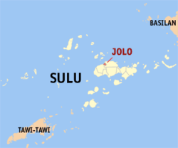
Basisdaten Bezirk: Autonomous Region in Muslim Mindanao Provinz: Sulu Barangays: 8 Distrikt: 1. Distrikt von Sulu PSGC: 156602000 Einkommensklasse: 3. Einkommensklasse Haushalte: 12.814 Zensus 1. Mai 2000Einwohnerzahl: 140.307 Zensus 1. August 2007Koordinaten: 5° 59′ N, 121° 8′ O5.9880555555556121.13583333333Koordinaten: 5° 59′ N, 121° 8′ O Postleitzahl: 7400 Offizielle Webpräsenz: Jolo Geographische Lage auf den Philippinen 

Jolo Jolo ist eine philippinische Stadtgemeinde in der Provinz Sulu auf der gleichnamigen Insel Jolo. Jolo hat 110.858 Einwohner (1. Januar 2005). Jolo ist Sitz der Provinzregierung der Provinz Sulu.
Jolo war Zentrum des Sultanats von Sulu.
Baranggays
Jolo ist politisch in acht Baranggays unterteilt.
- Alat
- Asturias
- Bus-Bus
- Chinese Pier
- San Raymundo
- Takut-Takut
- Tulay
- Walled City
Stadtgemeinden in der Provinz SuluStadtgemeinden: Hadji Panglima Tahil | Indanan | Jolo | Kalingalan Caluang | Lugus | Luuk | Maimbung | Old Panamao | Omar | Pandami | Panglima Estino | Pangutaran | Parang | Pata | Patikul | Siasi | Talipao | Tapul | Tongkil
Wikimedia Foundation.
Schlagen Sie auch in anderen Wörterbüchern nach:
Jolo, Sulu — Jolo is a 2nd class municipality in the province of Sulu, Philippines. It is the capital municipality of Sulu. According to the 2000 census, it has a population of 87,998 people in 12,814 households.Jolo was the center of the government of the… … Wikipedia
Jolo (disambiguation) — Jolo may refer to: * Jolo Island * Jolo, Sulu * Jolo, West Virginia * Jolo is also the nickname of Swedish author Jan Olof Olsson … Wikipedia
Joló — Dieser Artikel beschreibt die philippinische Insel Jolo, für die gleichnamige Stadtgemeinde siehe Jolo (Sulu). Jolo ist eine 893 km² große philippinische Insel mit etwa 300.000 Einwohnern. Inhaltsverzeichnis 1 Geographie … Deutsch Wikipedia
Jolo Airport — Infobox Airport name = Jolo Airport nativename = Paliparan ng Jolo IATA = JOL ICAO = RPMJ type = Public operator = Air Transportation Office city served = Jolo, Sulu elevation f = 118 elevation m = 36 coordinates =… … Wikipedia
Jolo — Infobox Islands name = Jolo image caption = Map of Sulu showing the location of Jolo locator Location map|Philippines|lat=5.983333|long=121.133333|width=175|float=center map custom = yes native name = Sulu native name link = location = South East … Wikipedia
Jolo — Carte de Jolo. Géographie Pays … Wikipédia en Français
Sulu-Archipel — Karte des Sulu Archipels Gewässer Pazifischer Ozean Geographisch … Deutsch Wikipedia
SULU (ARCHIPEL DES) — SULU ARCHIPEL DES Petit archipel philippin d’une centaine d’îles qui s’étend entre la péninsule de Zamboanga (Mindanao) et le nord est de Bornéo. Il est formé par les multiples sommets émergés de deux longues chaînes sous marines parallèles et de … Encyclopédie Universelle
Sulu — Sulu, mar de ► Archipiélago y prov. de Filipinas, entre los mares de Sulu (N) y Célebes (S); 1 600 km2 y 360 588 h. Cap., Joló. Las islas más importantes son las de Joló y Tawitawi … Enciclopedia Universal
Jolo — [ xolo], 1) kulturell und politisch wichtigste Insel der Suluinseln der Philippinen, 893 km2, 240 200 Einwohner; von den muslimischen Tausug bewohnt. Die Bewohner leben v. a. von der Landwirtschaft und der Fischerei. 2) Hafenstadt auf der … Universal-Lexikon
Jolo (Sulu)


18+
© Academic, 2000-2024
- Kontaktieren Sie uns: Unterstützung, Werbung
Wörterbücher Export, schritte mit PHP, Joomla, Drupal, WordPress, MODx.