- Kaukura
-
Kaukura NASA-Bild von Kaukura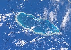
Gewässer Pazifischer Ozean Archipel Tuamotu-Archipel Geographische Lage 15° 45′ S, 146° 41′ W-15.75-146.68333333333Koordinaten: 15° 45′ S, 146° 41′ W 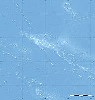

Anzahl der Inseln 65 Hauptinsel Tuteva Landfläche 11 km² Lagunenfläche 434 km² Einwohner 542 (2007) Karte von Kaukura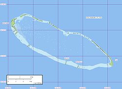
Kaukura ist ein Atoll des Tuamotu-Archipels in Französisch-Polynesien.
Geographie
Das nächstgelege Atoll Arutua ist 16 km östlich entfernt. Das Atoll ist 48 km lang und 16 km breit. Es existiert nur ein schiffbarer Zugang zum Meer. Geographisch gesehen gehört das Atoll zu den Palliser-Inseln, administrativ zur Gemeinde Arutua.
Das einzige Dorf des Atolls, Raitahiti, liegt auf der Hauptinsel Tuteva im Nordwesten. Dort befindet sich auch das 1994 eröffnete Flugfeld.
Der Tourismus hat den traditionellen Fischfang als wichtigsten Wirtschaftszweig verdrängt.
Geschichte
Das Atoll wurde 1722 durch den niederländischen Kapitän Jakob Roggeveen entdeckt.
Weblinks
 Commons: Kaukura – Sammlung von Bildern, Videos und Audiodateien
Ahe | Ahunui | Akiaki | Amanu | Anaa | Anuanuraro | Anuanurunga | Apataki | Aratika | Arutua | Faaite | Fakahina | Fakarava | Fangatau | Fangataufa | Gambier | Hao | Haraiki | Héréhérétué | Hikueru | Hiti | Katiu | Kauehi | Kaukura | Makatea | Makemo | Mangareva | Manihi | Manuhangi | Maria Est | Marokau | Marutea Nord | Marutea Sud | Mataiva | Matureivavao | Morane | Motutunga | Mururoa | Napuka | Nengonengo | Niau | Nihiru | Nukutavake | Nukutepipi | Paraoa | Pinaki | Puka-Puka | Puka Rua | Rangiroa | Raraka | Raroia | Ravahere | Reao | Reitoru | Rekareka | Taenga | Tahanea | Taiaro | Takapoto | Takaroa | Takume | Tatakoto | Tauere | Tekokota | Tematangi | Temoe | Tenararo | Tenarunga | Tepoto Nord | Tepoto Sud | Tikehau | Tikei | Toau | Tuanake | Tureia | Vahanga | Vahitahi | Vairaatea | Vanavana
Wikimedia Foundation.
Schlagen Sie auch in anderen Wörterbüchern nach:
Kaukura — is an atoll in the Tuamotu group in French Polynesia. Length 48 Km, width 15 Km. It is located in the western area of the archipelago, 58 Km SW of Rangiroa. The closest land is Arutua Atoll, only 16 Km to the East.Kaukura Atoll is elongated, with … Wikipedia
Kaukura — Vue satellite de la NASA Géographie Pays … Wikipédia en Français
kaukura — sf. R, MŽ2128, N, kaukūra J žr. kaukara … Dictionary of the Lithuanian Language
Kaukura Airport — is an airport on Kaukura Atoll in French Polynesia (IATA: KKR, ICAO: NTGK). The airport is 1 km north of Raitahiti. Airlines and destinations Air Tahiti (Papeete) External links NTGK – KAUKURA (PDF). AIP from French Service d… … Wikipedia
kaukura — कौकुर … Indonesian dictionary
KKR — Kaukura Atoll, Tuamotu Islands (Regional » Airport Codes) Korringa Kohn Rostoker approximation (Academic & Science » Physics) *** Kolberg, Kravis, and Roberts (Business » Firms) … Abbreviations dictionary
Îles Palliser — 15° 07′ 30″ S 147° 38′ 46″ W / 15.125, 147.646 … Wikipédia en Français
Arutua — Localización de la comuna de Arutua en las Tuamotu. Arutua es un atolón de las Tuamotu en la Polinesia Francesa. Está situado al noroeste del archipiélago, a 406 km al noreste de Tahití y a 40 km al sureste de Rangiroa. Es un atolón de forma casi … Wikipedia Español
Tuamotus — Native name: Tuamotu Flag of the Tuamotu Islands … Wikipedia
Palliser Islands — The Palliser Islands are a subgroup of the Tuamotu group in French Polynesia. They are located in the northwest of the main group of atolls.The group includes: *Apataki *Aratika *Arutua *Fakarava *Kaukura *Mataiva *Rangiroa *Makatea *Tikehau… … Wikipedia
Kaukura


18+
© Academic, 2000-2024
- Kontaktieren Sie uns: Unterstützung, Werbung
Wörterbücher Export, schritte mit PHP, Joomla, Drupal, WordPress, MODx.