Khiri Mat

Khiri Mat
Khiri Mat
คีรีมาศ
Provinz: Chiang Mai
Fläche: 521,9 km²
Einwohner: 56.585 (2005)
Bev.dichte: 108,4 E./km²
PLZ: 64160
Geocode: 6403
Karte
Karte von Chiang Mai, Thailand mit Khiri Mat

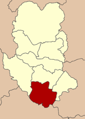
Amphoe Khiri Mat (in Thai: อำเภอ คีรีมาศ) ist der südlichste Landkreis (Amphoe) der Provinz (Changwat) Sukhothai in Nordthailand.

Inhaltsverzeichnis

Geographie

Benachbarte Landkreise (von Nordwesten im Uhrzeigersinn): die Amphoe Ban Dan Lan Hoi, Mueang Sukhothai und Kong Krailat der Provinz Sukhothai, sowie Bang Rakam der Provinz Phitsanulok und Phran Kratai der Provinz Kamphaeng Phet.

Geschichte

Der Kreis hieß ursprünglich Tannot und wurde im Jahr 1939 in Khiri Mat umbenannt.[1]

Verwaltung

Der Kreis ist in zehn Kommunen (Tambon) eingeteilt, die sich weiter in 101 Dörfer (Mubaan) unterteilen.

Es gibt zwei Kleinstädte (Thesaban Tambon) im Bezirk:

  • Thung Luang (Thai: เทศบาลตำบลทุ่งหลวง) besteht aus dem gesamten gleichnamigen Tambon.
  • Ban Tanot (Thai: เทศบาลตำบลบ้านโตนด) besteht aus Teilen des Tambon Tanot.

Es gibt außerdem neun „Tambon Administrative Organizations“ (TAO, องค์การบริหารส่วนตำบล - Verwaltungs-Organisationen).

Nr. Name Thai Dörfer Einw.
1. Tanot โตนด 17 9.344
2. Thung Luang ทุ่งหลวง 13 7.807
3. Ban Pom บ้านป้อม 9 4.917
4. Sam Phuang สามพวง 10 5.105
5. Si Khiri Mat ศรีคีรีมาศ 11 5.203
6. Nong Chik หนองจิก 12 7.946
7. Na Choeng Khiri นาเชิงคีรี 10 5.776
8. Nong Krading หนองกระดิ่ง 6 3.418
9. Ban Nam Phu บ้านน้ำพุ 8 5.017
10. Thung Yang Mueang ทุ่งยางเมือง 5 2.052

Einzelnachweise

  1. พระราชกฤษฎีกาเปลี่ยนนามอำเภอ กิ่งอำเภอ และตำบลบางแห่ง พุทธศักราช ๒๔๘๒. In: Royal Gazette. 56, Nr. 0 ก, 17. April 1939, S. 354-364

Weblinks


16.83333333333399.8016666666677Koordinaten: 16° 50′ N, 99° 48′ O


Wikimedia Foundation.

Игры ⚽ Поможем решить контрольную работу

Schlagen Sie auch in anderen Wörterbüchern nach:

  • Khiri Mat — Original name in latin Khiri Mat Name in other language Amphoe Khiri Mat, Khiri Mat, khirimas State code TH Continent/City Asia/Bangkok longitude 16.83333 latitude 99.8 altitude 53 Population 11272 Date 2012 01 16 …   Cities with a population over 1000 database

  • Amphoe Khiri Mat — Khiri Mat คีรีมาศ Provinz: Sukhothai Fläche: 521,9 km² Einwohner: 56.585 (2005) Bev.dichte: 108,4 E./km² PLZ: 64160 …   Deutsch Wikipedia

  • Amphoe Khiri Mat — Infobox Amphoe name=Khiri Mat thai=คีรีมาศ province=Sukhothai capital=Si Khiri Mat coordinates=coord|16|50|0|N|99|48|6|E|type:adm2nd region:TH capital=Tanot area=521.9 population=56,585 population as of=2005 density=108.4 postal code=64160… …   Wikipedia

  • Amphoe Khiri Mat — Admin ASC 2 Code Orig. name Amphoe Khiri Mat Country and Admin Code TH.09.1152875 TH …   World countries Adminstrative division ASC I-II

  • Liste des amphoe — Ceci est la liste des districts (amphoe) de Thaïlande, triés par province. Sommaire 1 Amnat Charoen 2 Ang Thong 3 Bangkok 4 Buriram …   Wikipédia en Français

  • Sukhothai Province — Infobox Thai Province name = Sukhothai thai = สุโขทัย capital = New Sukhothai area = 6,596.1 arearank = 31st population = 593,264 population as of = 2000 populationrank = 41st density = 90 densityrank = 49th isocode = TH 64 governor = Wanchai… …   Wikipedia

  • List of districts of Thailand — The is a list of districts ( amphoe ) of Thailand, sorted by province =Amnat Charoen= Mueang Amnat Charoen Chanuman Pathum Ratchawongsa Phana Senangkhanikhom Hua Taphan Lue Amnat =Ang Thong= Mueang Ang Thong Chaiyo Pa Mok Pho Thong Sawaeng Ha… …   Wikipedia

  • Ban Dan Lan Hoi — บ้านด่านลานหอย Provinz: Sukhothai Fläche: 1.018,11 km² Einwohner: 42.074 (2005) Bev.dichte: 41 E./km² PLZ: 64140 …   Deutsch Wikipedia

  • Kong Krailat — กงไกรลาศ Provinz: Chiang Mai Fläche: 502,382 km² Einwohner: 64.521 (2005) Bev.dichte: 128,4 E./km² PLZ: 64170 …   Deutsch Wikipedia

  • TH-64 — Sukhothai สุโขท้ย Statistik Hauptstadt: Sukhothai Tel.vorwahl: 055 …   Deutsch Wikipedia

Share the article and excerpts

Direct link
Do a right-click on the link above
and select “Copy Link”