- Kidsty Pike
-
Kidsty Pike 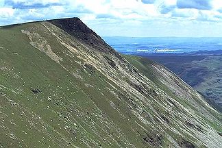
Kidsty Pike von Westen. Am rechten Bildrand ist ein Stück des Haweswater zu erkennen
Höhe 780 m Lage Cumbria, England Gebirge Cumbrian Mountains Geographische Lage 54° 30′ 20″ N, 2° 51′ 18″ W54.505555555556-2.855780Koordinaten: 54° 30′ 20″ N, 2° 51′ 18″ W 

Kidsty Pike ist einer der 214 Wainwright genannten Berge (Fell) im nordenglischen Nationalpark Lake District und wird den Far Eastern Fells zugeordnet.[1]
Der Autor Alfred Wainwright führte seinen Coast to Coast Walk über den Kidsty Pike als höchsten Punkt dieser Wanderung quer über die britische Insel.[2]Name
Den Namen leitet man her von den altnordischen Bezeichnungen kith = junge Ziege, stigr = Pfad und pik = Gipfel als Gipfel beim Ziegenpfad. [3]
Topographie
Kidsty Pike liegt auf dem Grat, der westlich des Haweswater Reservoir vom ehemaligen Dorf Mardale zum Rampsgill Head verläuft und die Täler Riggindale und Randale trennt.
Ein kurzes Plateau führt nach Westen zu den Straits of Riggindale. Hier führen steile unbegehbare Hänge zum 400 m tiefer gelegenen Hayeswater in einem Tal, das sich nach Nordwesten ins Patterdale öffnet; nach Süden besteht eine Verbindung zum Berg High Street, nach Norden gelangt man über das Bannerdale und das Boredale nach Howtown am Ullswater.
Während die Nordseite eine relativ geringe Steigung aufweist, fällt die Südseite über schroffe Felsen und Geröllhalden steil ins 500 m niedrigere Riggindale ab.
Anmerkungen
- ↑ Wainwright, Alfred: Pictorial Guide to the Lakeland Fells, Band 2, The Far Eastern Fells
- ↑ Wainwright, Alfred: Coast to Coast Walk
- ↑ Robert Gambles, Lake District Place Names, Dalesman Books, Clapham 1985
Kategorien:- Berg unter 1000 Meter
- Berg in Europa
- Berg in England
- Lake District


Wikimedia Foundation.